Photo Credits (5)
Difficulty
Moderate
Trail Length
2.4 miles
Trail Type
Out And Back
Elevation Gain
350 ft
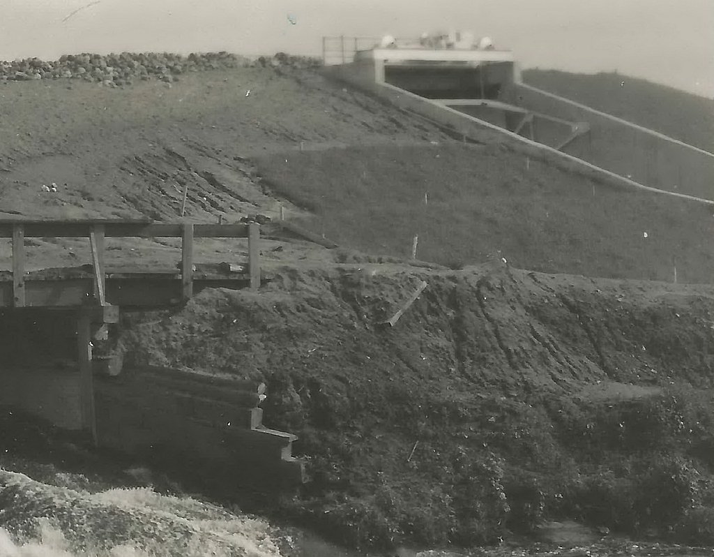
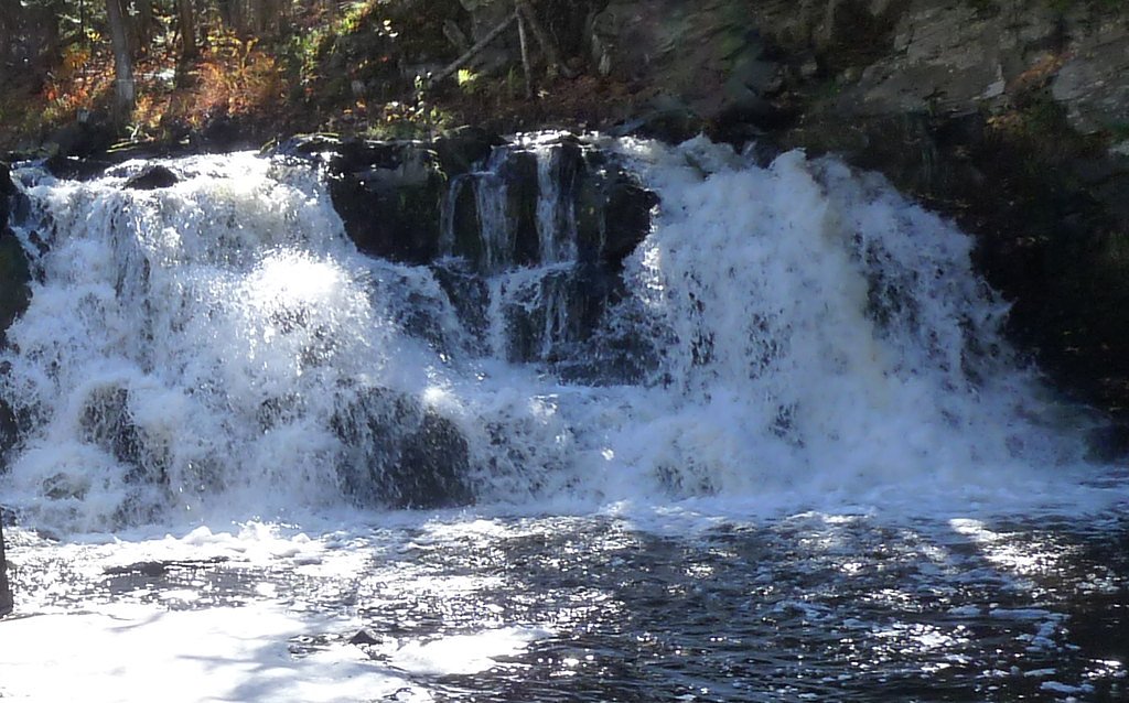
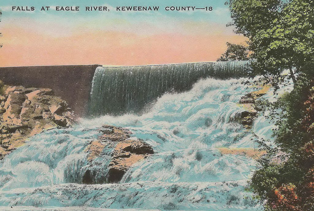
About Power Dam Falls
Power Dam Falls is a small, scenic cascade on the Ocqueoc River that sits at the remnants of a historic dam site. The falls offer a peaceful spot to watch water thread through sculpted rock and trees — a compact, photogenic stop for hikers and photographers. The site lies on city-owned Local Forest land, designated as an LRMA and managed by the city, which helps keep the setting quietly maintained and accessible to the public. Reaching the falls typically involves a short, rewarding hike: the common approach is an out-and-back route of about 2.4 miles round-trip with roughly 350 feet of elevation gain and is usually rated moderate. Trails in this area are locally maintained rather than part of a federal system, so visitors should come prepared for natural tread, roots, and occasional uneven footing while enjoying the tranquil riverside scenery.
The Setting
Power Dam Falls sits at 883 feet within Local Forest, fed by the Falls River, in the foothills of Michigan.
Trail & Hike Details
The Approach
The moderate 2.4-mile out-and-back trail gains 350 feet of elevation on the way to the falls.
Trail Description
Trail type: Out-and-back. Distance: 2.4 miles round-trip. Elevation gain: approximately 350 feet. Difficulty: Moderate. The route is a locally maintained access trail on city-owned Local Forest land (designation LRMA) and is managed by the city. No USFS trail name or number is listed in the provided data; specific surface, grade, and USFS trail class information were not provided, so expect natural tread and variable footing along the route.
What to Expect
Visitors can expect a small waterfall with a historic dam structure nearby. The area is quiet and surrounded by natural beauty, making it a good spot for photography or a peaceful visit.
Accessibility
The trail is not wheelchair accessible. Uneven terrain and elevation changes require steady footing.
Frequently Asked Questions
🐶 Are Dogs Allowed at Power Dam Falls?
❌ Dogs are not allowed
Are There Any Fees or Permits Required?
🆖 No fees required
🏊 Is There Swimming at Power Dam Falls?
❌ Swimming is not allowed
When to Visit
Spring and early summer are ideal times to visit, as water flow is typically higher during these seasons.
Seasonal Access
The best time to visit is Spring, Summer, and Fall. Winter access may be limited.
Safety Information
Be cautious near the dam structure and water's edge, as the terrain may be slippery or uneven. Always supervise children closely.
Current Water Conditions
42 ft³/s
Current discharge — how much water is flowing
About average for this time of year
Based on 11 years of record
4.40 ft
Water depth at gauge
56°F
ColdBracing — limit time in water
7-Day Discharge Trend
What does this mean for your visit?
Flow is about average for this time of year. Water temperature is a bracing 56 degrees F, limit your time in the water. Mineral content is typical.
Water Quality
Conductance
Dissolved minerals in the water
About This Gauge
7-Day Flow Outlook
Based on the USGS gauge FALLS RIVER NEAR L'ANSE, MI (0 km away).
Today
Moderate
42 cfs
9/10Tomorrow
Moderate
41 cfs
9/10Mon
Strong
47 cfs
7/10Tue
Strong
60 cfs
7/10Wed
Strong
68 cfs
7/10Thu
Strong
50 cfs
7/10Fri
Strong
43 cfs
7/10Best window: Today — moderate flow, sunny (trip score 9/10).
Best time of year: this gauge typically runs highest from mid March to late May, peaking in April.
How we calculate this
This is a transparent outlook, not a precise forecast. We take the waterfall's current flow strength (how it ranks against its historical normal for today, from the nearest USGS stream gauge), carry that ranking forward along the gauge's seasonal curve, and nudge it for forecast rain. Confidence is highest for the next day or two and falls further out. Always check official conditions and your own judgment before visiting — high flows can be dangerous.
Know when to go.
Get a free email alert when waterfalls near L'Anse hit peak flow. We only send when conditions are worth the trip — no weekly newsletters, no spam.
Weather Forecast
Location & Access
Getting There
Power Dam Falls is located near Ocqueoc Falls in Presque Isle County, Michigan. It can be accessed via local roads, and visitors should follow signs for the Ocqueoc River or Power Dam Road.
Get Directions on Google MapsParking
There is limited parking available near the site. Visitors may need to park along the road or in designated areas nearby.
Elevation
883 feet above sea level
Coordinates
46.735350° N, -88.442533° W
Land Management
Managed by CITY
Visitor Tips & Gear
Wear sturdy shoes as the terrain near the falls may be uneven. Bring insect repellent during warmer months, and check local conditions before visiting.
As an Amazon Associate, we earn from qualifying purchases.
With 2.4 miles and 350 ft of elevation gain, sturdy boots and trekking poles will help on this moderate trail. Sun exposure on the trail makes good sun protection a must in summer.

Polarized Sunglasses (Knockaround)
Cuts glare off the water so you actually see the falls — and your photos turn out better too.

Columbia Watertight II Rain Jacket
Packs into its own pocket, seam-sealed, and keeps you dry from spray and surprise rain.

Earth Pak Waterproof Dry Bag
Keeps your phone and gear dry when waterfall mist soaks everything else.

Waterproof Phone Pouch (AiRunTech)
Cheap insurance — take photos right next to the falls without killing your phone.

Timberland Euro Sprint Mid Waterproof
Trusted waterproof boot with premium leather and grippy rubber sole — reliable on rocky, wet trails.

TrailBuddy Trekking Poles
Lightweight aluminum, cork grips, and flip-locks that actually hold — a best-seller for good reason.
Where to Stay

UP Escape in the Pines

Champion Vacation Rental with Fire Pit!

Whole home, private lake, sauna, WFH office

Tiny Woodland Cottage Retreat with Yard in Pelkie
Browse vacation cabins and private rentals nearby
Unique outdoor stays — tents, yurts, and treehouses
Rent a campervan or RV for your waterfall road trip
Some links are affiliate links. We may earn a commission at no extra cost to you.
Nearby Campground
Sturgeon River Gorge Wilderness
14.6 miles away · 0 sites
The Wild and Scenic Sturgeon River rushes out of the northern portion of this wilderness, over the 20 foot volcanic outcroppings of Sturgeon Falls, and through a gorge that reaches 350 feet in depth and a mile in width. Throughout this rugged, steep Wilderness, the Sturgeon and Little Silver Rivers and their tributaries have carved falls, rapids, ponds, oxbows, and terraces. Stunning views are possible from the eastern rim of the gorge. Except for a few naturally bare slopes, most of the land is
Book on Recreation.govAdditional Information
Nearby Attractions
Ocqueoc Falls, the only universally accessible waterfall in Michigan, is located nearby and is worth a visit.
Wildlife
The area around the falls may feature local wildlife such as birds, deer, and small mammals.
Cities near Power Dam Falls
Nearby Waterfalls

Other waterfalls named Power Dam Falls
1 other waterfall shares this name across the U.S.
Writing about Power Dam Falls? Embed this waterfall on your site for free.