Gomanche Falls
By Armen Suny · Last verified May 2026
Difficulty
Easy
Trail Length
0.6 miles
Trail Type
Out And Back
Elevation Gain
100 ft
About Gomanche Falls
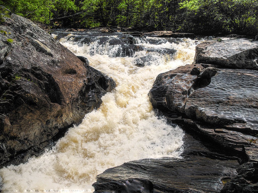
Gomanche Falls is a tucked-away waterfall on Michigan’s L'Anse Reservation, offering a peaceful, low-key stop for hikers who prefer quieter natural settings. The falls sit within a wooded pocket of tribal land and are best appreciated as a brief nature break rather than a major destination — ideal for visitors looking for a short scenic outing. The site is on land owned by DESG and managed by the tribal authority for the L'Anse Reservation (designation: TRIBL; manager: TRIB). The approach is short and accessible: the trail to the falls is a 0.6-mile out-and-back with about 100 feet of elevation gain and is rated easy, making it suitable for families and casual walkers. Because Gomanche Falls lies on tribal land, check with the tribal manager (TRIB) for any access guidance or seasonal updates before you go.
The Setting
Gomanche Falls sits at 906 feet within L'Anse Reservation, fed by the Silver River, in the foothills of Michigan.
Trail & Hike Details
The Approach
The easy 0.6-mile out-and-back trail gains 100 feet of elevation on the way to the falls.
Trail Description
This is a short, easy 0.6-mile out-and-back trail with approximately 100 feet of elevation gain. Difficulty is listed as easy and the route is typically completed quickly; trail length and gain make it suitable for most hikers. Detailed surface, grade, and USFS trail-class data are not provided for this site, and the path may be minimally improved or informal in places. Visitors should check current conditions and access information with the L'Anse Reservation manager (TRIB) before heading out.
What to Expect
Expect a peaceful and natural setting with a waterfall surrounded by forest. The area may be remote and less developed, so plan accordingly.
Accessibility
The trail is short and relatively flat, but the surface may be uneven. Contact the managing agency for accessibility details.
Frequently Asked Questions
🐶 Are Dogs Allowed at Gomanche Falls?
❌ Dogs are not allowed
Are There Any Fees or Permits Required?
🆖 No fees required
🏊 Is There Swimming at Gomanche Falls?
❌ Swimming is not allowed
When to Visit
Spring and early summer are ideal for visiting, as water flow is typically higher during these seasons.
Seasonal Access
The best time to visit is Spring, Summer, and Fall. Winter access may be limited.
Safety Information
The trail and area around the falls may be slippery, uneven, or unmarked. Visitors should exercise caution and avoid visiting during inclement weather.
Current Water Conditions
184 ft³/s
Current discharge — how much water is flowing
Much higher than usual for this time of year
Based on 24 years of record
7.44 ft
Water depth at gauge
7-Day Discharge Trend
What does this mean for your visit?
The water is flowing much higher than usual, expect an impressive display.
About This Gauge
7-Day Flow Outlook
Based on the USGS gauge SILVER RIVER NEAR L'ANSE, MI (6 km away).
Today
Strong
196 cfs
10/10Tomorrow
Strong
170 cfs
10/10Sun
Strong
178 cfs
8/10Mon
Roaring
225 cfs
6/10Tue
Roaring
243 cfs
6/10Wed
Roaring
194 cfs
6/10Thu
Roaring
175 cfs
6/10Best window: Today — strong flow, mostly sunny (trip score 10/10).
Best time of year: this gauge typically runs highest from mid March to late May, peaking in April.
How we calculate this
This is a transparent outlook, not a precise forecast. We take the waterfall's current flow strength (how it ranks against its historical normal for today, from the nearest USGS stream gauge), carry that ranking forward along the gauge's seasonal curve, and nudge it for forecast rain. Confidence is highest for the next day or two and falls further out. Always check official conditions and your own judgment before visiting — high flows can be dangerous.
Know when to go.
Get a free email alert when waterfalls near Zeba hit peak flow. We only send when conditions are worth the trip — no weekly newsletters, no spam.
Weather Forecast
Location & Access
Getting There
The exact location of Gomanche Falls is not well-documented, but it is believed to be accessible via a forested area in Michigan. Visitors should consult local maps or guides for precise directions.
Get Directions on Google MapsParking
Parking availability is unclear, but visitors may need to park along nearby roads or at a trailhead if one exists.
Elevation
906 feet above sea level
Coordinates
46.757850° N, -88.359100° W
Land Management
Managed by TRIB
Visitor Tips & Gear
Bring a map or GPS device as the location may not be well-marked. Wear sturdy footwear and be prepared for varying trail conditions.
As an Amazon Associate, we earn from qualifying purchases.
For this easy 0.6 miles trail, lightweight trail shoes and a water bottle are usually sufficient. Sun exposure on the trail makes good sun protection a must in summer.

Columbia Watertight II Rain Jacket
Packs into its own pocket, seam-sealed, and keeps you dry from spray and surprise rain.

Earth Pak Waterproof Dry Bag
Keeps your phone and gear dry when waterfall mist soaks everything else.

Waterproof Phone Pouch (AiRunTech)
Cheap insurance — take photos right next to the falls without killing your phone.

Polarized Sunglasses (Knockaround)
Cuts glare off the water so you actually see the falls — and your photos turn out better too.

Osprey Daylite Daypack
Light, organized, and just the right size for a day hike — fits water, snacks, and layers.

OR Sombriolet Sun Hat
UPF 50+ sun protection with vents so your head doesn't cook on exposed trail sections.
Where to Stay

AC4 Northwoods Getaway w Jetted Tub

Independence Stay Hotel and Long term suites

Trailside Furnished Apartment

UP Escape in the Pines
Browse vacation cabins and private rentals nearby
Unique outdoor stays — tents, yurts, and treehouses
Rent a campervan or RV for your waterfall road trip
Some links are affiliate links. We may earn a commission at no extra cost to you.
Nearby Campground
Sturgeon River Gorge Wilderness
18.8 miles away · 0 sites
The Wild and Scenic Sturgeon River rushes out of the northern portion of this wilderness, over the 20 foot volcanic outcroppings of Sturgeon Falls, and through a gorge that reaches 350 feet in depth and a mile in width. Throughout this rugged, steep Wilderness, the Sturgeon and Little Silver Rivers and their tributaries have carved falls, rapids, ponds, oxbows, and terraces. Stunning views are possible from the eastern rim of the gorge. Except for a few naturally bare slopes, most of the land is
Book on Recreation.govAdditional Information
Nearby Attractions
Other waterfalls and natural attractions in Michigan may be nearby, but specific recommendations are not documented.
Wildlife
The area may host typical Michigan wildlife such as deer, birds, and small mammals.
Cities near Gomanche Falls
Nearby Waterfalls
Writing about Gomanche Falls? Embed this waterfall on your site for free.