Difficulty
Moderate
Trail Length
2.4 miles
Trail Type
Out And Back
Elevation Gain
350 ft
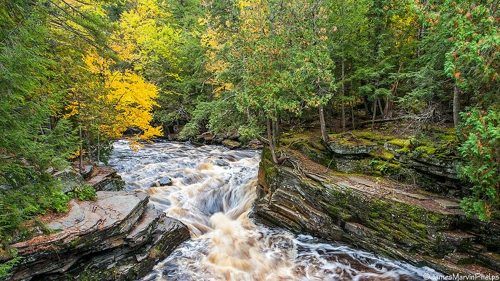
About Plumbago Falls
Plumbago Falls is a remote, scenic cascade tucked into Michigan’s Upper Peninsula along Plumbago Creek, which ultimately drains to the Ontonagon River. The falls drop through a rugged, forested gorge that feels deliberately wild — a rewarding destination for hikers who relish solitude, mossy rock walls, and the sound of running water rather than crowded overlooks. The route to the falls is short but requires a bit of effort: the out-and-back route is about 2.4 miles round trip with roughly 350 feet of elevation gain and is typically rated moderate. There isn’t immediate developed camping at the falls; the nearest formal camping is at Sturgeon River Gorge Wilderness, roughly 20 km away, so plan your trip and supplies accordingly. Boots, a map or GPS, and a willingness to navigate uneven tread will make the visit most enjoyable.
The Setting
Plumbago Falls sits at 1,552 feet along the Falls River, in the hills of Michigan.
Trail & Hike Details
The Approach
The moderate 2.4-mile out-and-back trail gains 350 feet of elevation on the way to the falls.
Trail Description
Out-and-back, 2.4 miles round trip with approximately 350 feet of elevation gain; rated moderate. The tread is natural and can be uneven with occasional overgrowth, winding through dense forest toward the gorge. Trail routing may be lightly marked in places, so expect some route-finding and bring navigation tools; the short distance and steady climb reward hikers with a secluded waterfall setting.
What to Expect
Dogs are welcome.
Accessibility
The trail is not wheelchair accessible. Uneven terrain and elevation changes require steady footing.
Frequently Asked Questions
🐶 Are Dogs Allowed at Plumbago Falls?
✅ Dogs are allowed
Are There Any Fees or Permits Required?
🆖 No fees required
🏊 Is There Swimming at Plumbago Falls?
❌ Swimming is not allowed
When to Visit
Spring and early summer are ideal times to visit, as the water flow is typically strongest due to snowmelt and rainfall.
Seasonal Access
The best time to visit is Spring, Summer, and Fall. Winter access may be limited.
Safety Information
The trail can be slippery and uneven, especially after rain. Be cautious of loose rocks and roots. Carry a first aid kit and let someone know your plans before heading out.
Current Water Conditions
31 ft³/s
Current discharge — how much water is flowing
About average for this time of year
Based on 11 years of record
4.26 ft
Water depth at gauge
61°F
CoolRefreshing for swimming
7-Day Discharge Trend
What does this mean for your visit?
Flow is about average for this time of year. Water temperature is a refreshing 61 degrees F, good for a quick swim. Mineral content is typical.
Water Quality
Conductance
Dissolved minerals in the water
About This Gauge
This gauge is on a nearby waterway and may not reflect exact conditions at the falls.
7-Day Flow Outlook
Based on the USGS gauge FALLS RIVER NEAR L'ANSE, MI (9 km away).
Today
Moderate
37 cfs
6/10Tomorrow
Moderate
47 cfs
6/10Wed
Moderate
54 cfs
6/10Thu
Moderate
39 cfs
6/10Fri
Moderate
34 cfs
6/10Sat
Moderate
31 cfs
6/10Sun
Moderate
33 cfs
6/10Best window: Today — moderate flow, showers and thunderstorms likely then mostly cloudy (trip score 6/10).
Best time of year: this gauge typically runs highest from mid March to late May, peaking in April.
How we calculate this
This is a transparent outlook, not a precise forecast. We take the waterfall's current flow strength (how it ranks against its historical normal for today, from the nearest USGS stream gauge), carry that ranking forward along the gauge's seasonal curve, and nudge it for forecast rain. Confidence is highest for the next day or two and falls further out. Always check official conditions and your own judgment before visiting — high flows can be dangerous.
Know when to go.
Get a free email alert when waterfalls near L'Anse hit peak flow. We only send when conditions are worth the trip — no weekly newsletters, no spam.
Weather Forecast
Location & Access
Getting There
Plumbago Falls is located near Rockland, Michigan, in the western Upper Peninsula. Access typically involves driving on forest roads, which may be unpaved and rough. Visitors should use a reliable map or GPS as signage may be limited.
Get Directions on Google MapsParking
Parking is available near the trailhead, but spaces may be limited and the area is not well-developed.
Elevation
1,552 feet above sea level
Coordinates
46.650216° N, -88.439183° W
Visitor Tips & Gear
Wear sturdy hiking boots as the trail can be uneven and muddy, especially after rain. Bring bug spray during the warmer months to protect against mosquitoes. Cell service may be limited, so plan accordingly.
As an Amazon Associate, we earn from qualifying purchases.
With 2.4 miles and 350 ft of elevation gain, sturdy boots and trekking poles will help on this moderate trail. Sun exposure on the trail makes good sun protection a must in summer.

Columbia Watertight II Rain Jacket
Packs into its own pocket, seam-sealed, and keeps you dry from spray and surprise rain.

Earth Pak Waterproof Dry Bag
Keeps your phone and gear dry when waterfall mist soaks everything else.

Waterproof Phone Pouch (AiRunTech)
Cheap insurance — take photos right next to the falls without killing your phone.

Timberland Euro Sprint Mid Waterproof
Trusted waterproof boot with premium leather and grippy rubber sole — reliable on rocky, wet trails.

TrailBuddy Trekking Poles
Lightweight aluminum, cork grips, and flip-locks that actually hold — a best-seller for good reason.

Polarized Sunglasses (Knockaround)
Cuts glare off the water so you actually see the falls — and your photos turn out better too.
Where to Stay

UP Escape in the Pines

Champion Vacation Rental with Fire Pit!

Whole home, private lake, sauna, WFH office

Tiny Woodland Cottage Retreat with Yard in Pelkie
Browse vacation cabins and private rentals nearby
Unique outdoor stays — tents, yurts, and treehouses
Rent a campervan or RV for your waterfall road trip
Some links are affiliate links. We may earn a commission at no extra cost to you.
Nearby Campground
Sturgeon River Gorge Wilderness
12.5 miles away · 0 sites
The Wild and Scenic Sturgeon River rushes out of the northern portion of this wilderness, over the 20 foot volcanic outcroppings of Sturgeon Falls, and through a gorge that reaches 350 feet in depth and a mile in width. Throughout this rugged, steep Wilderness, the Sturgeon and Little Silver Rivers and their tributaries have carved falls, rapids, ponds, oxbows, and terraces. Stunning views are possible from the eastern rim of the gorge. Except for a few naturally bare slopes, most of the land is
Book on Recreation.govAdditional Information
Nearby Attractions
The Ontonagon River and Porcupine Mountains Wilderness State Park are nearby and offer additional outdoor activities.
Wildlife
The area is home to a variety of wildlife, including deer, birds, and occasionally black bears. Be cautious and respectful of the natural habitat.
Cities near Plumbago Falls
Nearby Waterfalls

Writing about Plumbago Falls? Embed this waterfall on your site for free.