Ozone Falls
Tennessee • 110 ft
By Armen Suny · Last verified Mar 2026
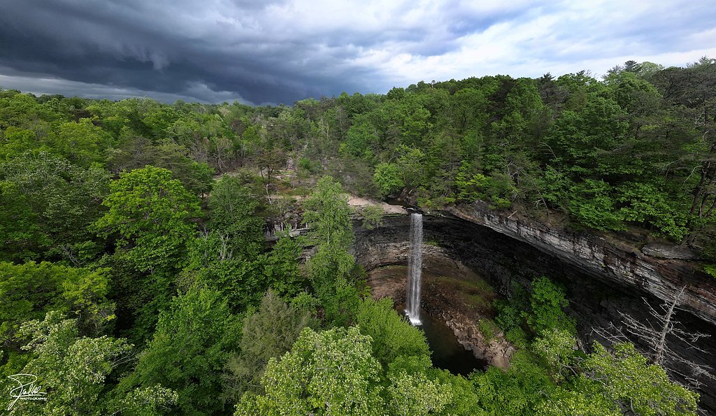
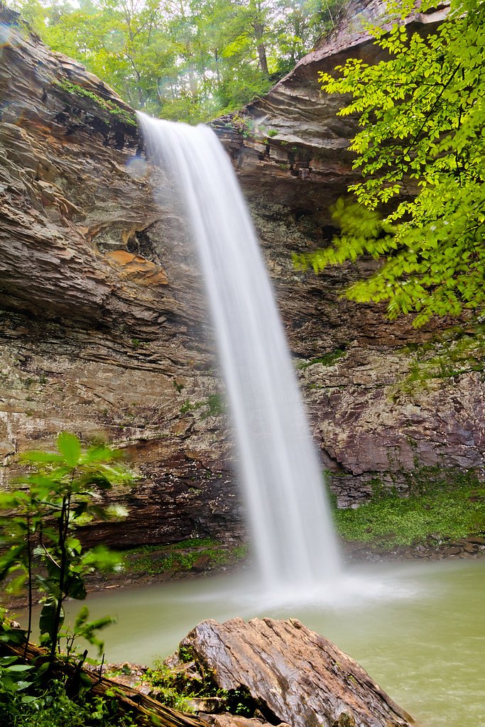
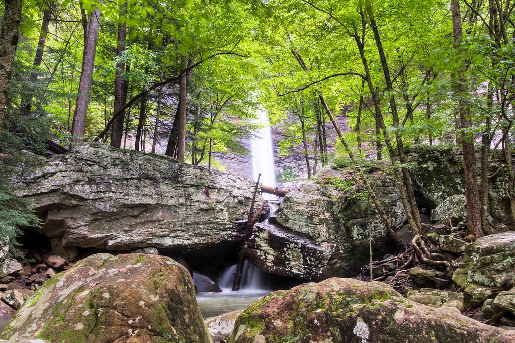
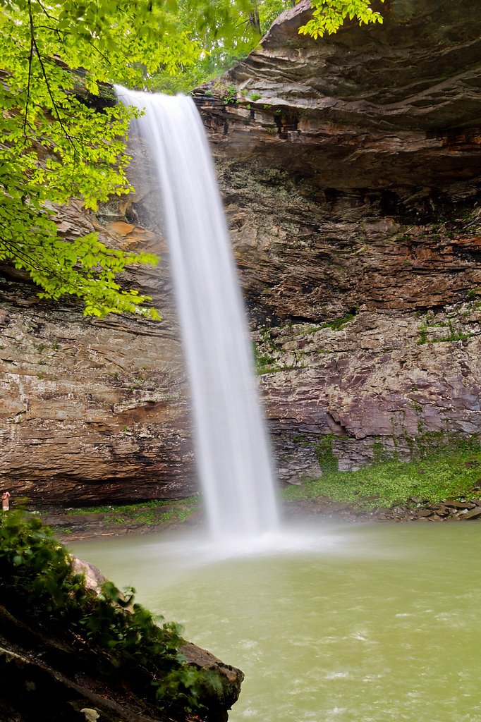

Photo Credits (5)
Difficulty
Easy
Trail Length
0.6 miles
Trail Type
Out And Back
Elevation Gain
100 ft
About Ozone Falls
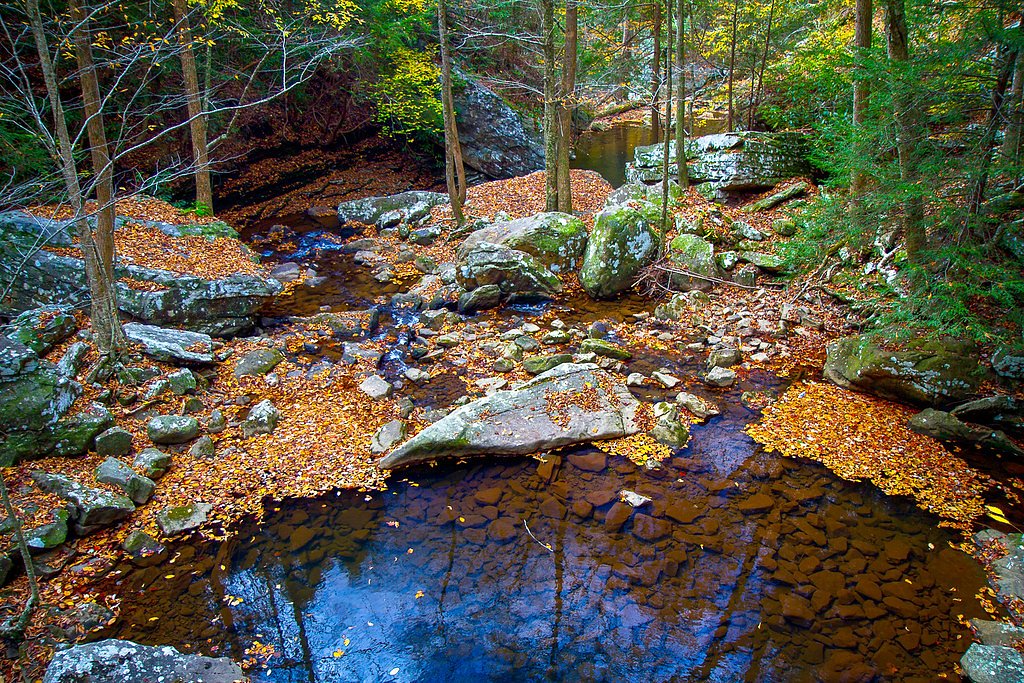
Ozone Falls is a striking 110-foot plunge on Fall Creek in Cumberland County, Tennessee. Nestled within the Ozone Falls State Natural Area and part of the Cumberland Trail State Park, the cascade drops into a rocky gorge framed by mixed hardwood forest on the Cumberland Plateau. The site is managed by OTHS and offers a dramatic, photogenic amphitheater that draws day hikers and photographers looking for a short, rewarding outing. Fall Creek drains a short section of the plateau between the Crab Orchard Mountains to the west and Walden Ridge to the east. The creek flows down from its source high in the Crab Orchard Mountains for about a mile before easing as it enters the community of Ozone, which contributes to the falls’ relatively accessible setting. Visitors should respect posted rules from park managers while enjoying the viewpoints and fragile gorge environment.
The Setting
Ozone Falls sits at 1,463 feet within Cumberland Trail, fed by the Daddys Creek, in the foothills of Tennessee. At 110 feet, it is among the taller waterfalls in Tennessee.
Height: 110 feet
Trail & Hike Details
The Approach
The easy 0.6-mile out-and-back trail gains 100 feet of elevation on the way to the falls.
Trail Description
The trail to Ozone Falls is a short, easy 0.6-mile out-and-back with roughly 100 feet of elevation gain, making it suitable for most hikers and families. The route leads to a viewing area at the top of the 110-foot falls and is a popular, often busy, short hike within Cumberland Trail State Park. For those wanting a closer look, a steep, rocky path descends into the gorge to view the waterfall from below; that descent requires care, as rock surfaces can be slippery—especially after rain. Trail type: out-and-back; length: 0.6 miles; elevation gain: ~100 ft; difficulty: easy.
What to Expect
The falls cascade 110 feet. Dogs are welcome.
Accessibility
The trail is short and relatively flat, but the surface may be uneven. Contact the managing agency for accessibility details.
Frequently Asked Questions
🐶 Are Dogs Allowed at Ozone Falls?
✅ Dogs are allowed
Are There Any Fees or Permits Required?
🆖 No fees required
🏊 Is There Swimming at Ozone Falls?
❌ Swimming is not allowed
When to Visit
Spring and early summer are ideal for visiting Ozone Falls, as the water flow is typically strongest during these seasons. Fall offers beautiful foliage, while winter provides a quieter experience.
Seasonal Access
The best time to visit is Spring, Summer, Fall, and Winter.
Safety Information
Exercise caution near the edge of the falls, as there are no barriers. The rocks can be slippery, especially after rain. The descent into the gorge is steep and requires careful footing.
Current Water Conditions
31 ft³/s
Current discharge — how much water is flowing
About average for this time of year
Based on 39 years of record
1.55 ft
Water depth at gauge
78°F
ComfortablePleasant for swimming
7-Day Discharge Trend
What does this mean for your visit?
Flow is about average for this time of year. The water is a comfortable 78 degrees F, pleasant for swimming. Expect crystal clear visibility and excellent dissolved oxygen levels. PH is normal at 8.2 and mineral content is typical.
Water Quality
Dissolved Oxygen
ExcellentSupports aquatic life
pH
NormalWithin healthy range (6.5-8.5)
Water Clarity
Crystal clearExcellent visibility
Conductance
Dissolved minerals in the water
About This Gauge
This gauge is on a nearby waterway and may not reflect exact conditions at the falls.
7-Day Flow Outlook
Based on the USGS gauge DADDYS CREEK NEAR HEBBERTSBURG, TN (13 km away).
Today
Moderate
31 cfs
6/10Tomorrow
Moderate
29 cfs
6/10Wed
Moderate
37 cfs
8/10Thu
Moderate
49 cfs
6/10Fri
Moderate
70 cfs
6/10Sat
Moderate
75 cfs
6/10Sun
Moderate
75 cfs
6/10Best window: Wed — moderate flow, sunny (trip score 8/10).
Best time of year: this gauge typically runs highest from early February to early March, peaking in February.
How we calculate this
This is a transparent outlook, not a precise forecast. We take the waterfall's current flow strength (how it ranks against its historical normal for today, from the nearest USGS stream gauge), carry that ranking forward along the gauge's seasonal curve, and nudge it for forecast rain. Confidence is highest for the next day or two and falls further out. Always check official conditions and your own judgment before visiting — high flows can be dangerous.
Know when to go.
Get a free email alert when waterfalls near Crab Orchard hit peak flow. We only send when conditions are worth the trip — no weekly newsletters, no spam.
Weather Forecast
Location & Access
Getting There
Ozone Falls is located off U.S. Highway 70 near the town of Ozone, Tennessee. It is approximately 4 miles from Crab Orchard and about 40 miles west of Knoxville.
Get Directions on Google MapsParking
There is a small parking area located near the trailhead along Highway 70. Parking is free but can fill up quickly, especially on weekends.
Elevation
1,463 feet above sea level
Coordinates
35.880071° N, -84.811057° W
Land Management
Managed by OTHS
Visitor Tips & Gear
Arrive early to secure parking, especially on weekends. Wear sturdy shoes if you plan to descend into the gorge. Be cautious near the edge of the falls as there are no railings. Bring water and snacks, as there are no facilities nearby.
As an Amazon Associate, we earn from qualifying purchases.
For this easy 0.6 miles trail, lightweight trail shoes and a water bottle are usually sufficient. Icy conditions are common in winter — traction cleats are a smart addition.

Columbia Watertight II Rain Jacket
Packs into its own pocket, seam-sealed, and keeps you dry from spray and surprise rain.

Polarized Sunglasses (Knockaround)
Cuts glare off the water so you actually see the falls — and your photos turn out better too.

Earth Pak Waterproof Dry Bag
Keeps your phone and gear dry when waterfall mist soaks everything else.

Waterproof Phone Pouch (AiRunTech)
Cheap insurance — take photos right next to the falls without killing your phone.

Kahtoola MICROspikes
Cult-favorite traction cleats that grip ice and wet rock — essential for winter waterfall hikes.

JOBY GorillaPod Starter Kit
Wraps around railings and rocks for long-exposure waterfall shots — no flat surface needed.
Where to Stay

Holiday Inn Express & Suites Crossville by IHG

Comfort Inn Harriman

Comfort Suites Crossville

Hampton Inn Crossville
Browse vacation cabins and private rentals nearby
Unique outdoor stays — tents, yurts, and treehouses
Rent a campervan or RV for your waterfall road trip
Some links are affiliate links. We may earn a commission at no extra cost to you.
Nearby Campground
Rock Creek Campground (TN)
15.5 miles away · 11 sites
Overview Rock Creek Campground is located near the Emory River in the Obed Wild and Scenic River.Recreation Whitewater paddling is available seasonally in the Obed WSR. Rock climbing is another challenging activity, as is boulder climbing. The Obed WSR sports several unique trails for hikers, most notably the Point Trail and a portion of the Cumberland Trail. Those who like to fish will enjoy the Obed WSR, as a variety of bass, bluegill, catfish and other fish populate the river. Birdwatching is
Book on Recreation.govAdditional Information
Nearby Attractions
Nearby attractions include Cumberland Mountain State Park and the Obed Wild and Scenic River.
Wildlife
The area is home to various bird species, small mammals, and reptiles. Visitors may also see wildflowers and ferns in the surrounding forest.
Cities near Ozone Falls
Nearby Waterfalls
Other waterfalls named Ozone Falls
1 other waterfall shares this name across the U.S.
Writing about Ozone Falls? Embed this waterfall on your site for free.