Photo Credits (5)
Difficulty
Moderate
Trail Length
2.4 miles
Trail Type
Out And Back
Elevation Gain
350 ft
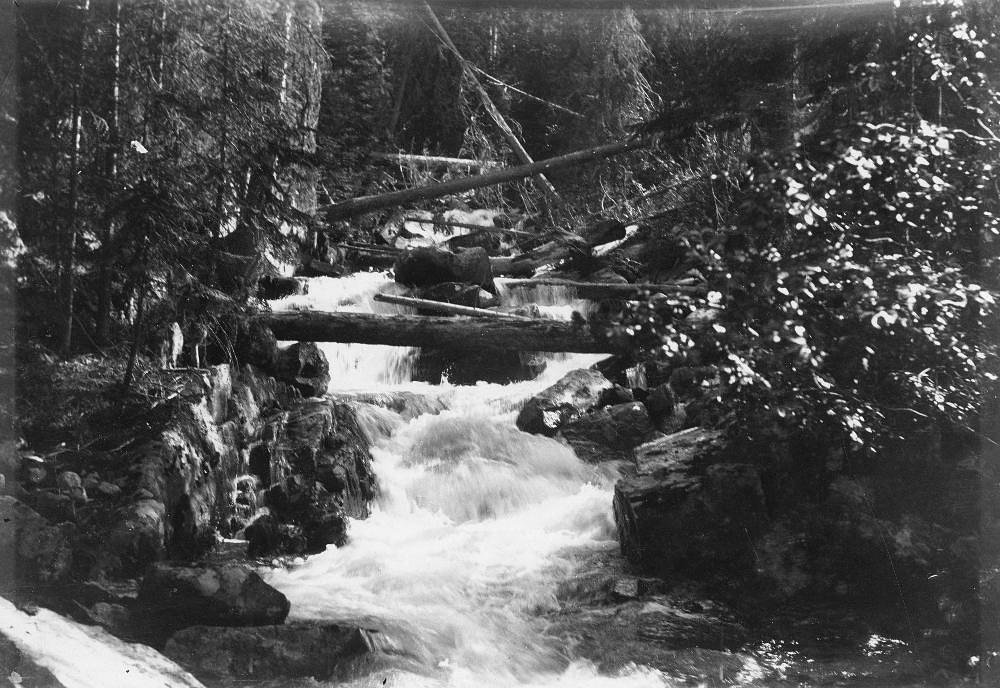
About North Fork Falls
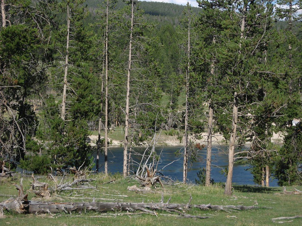
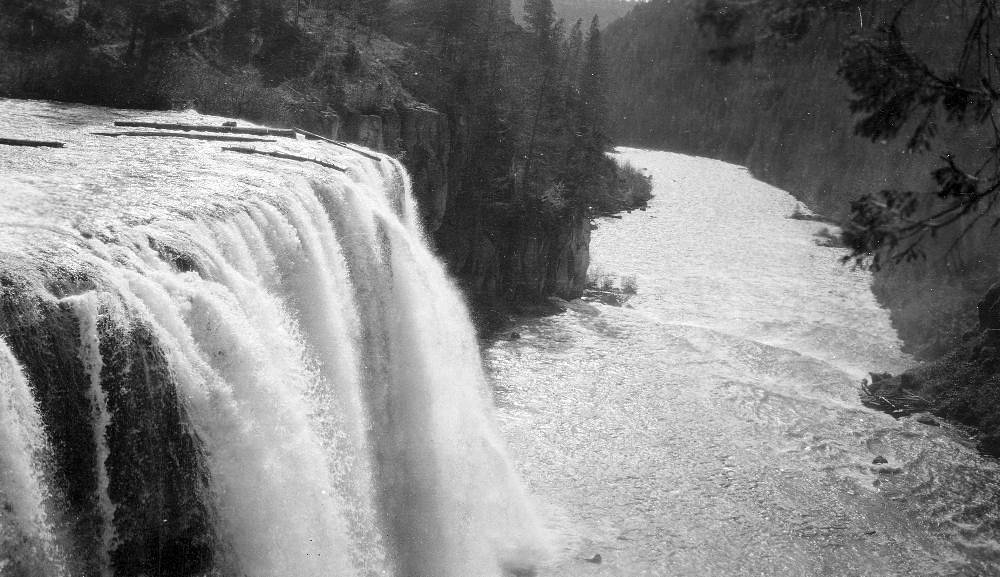
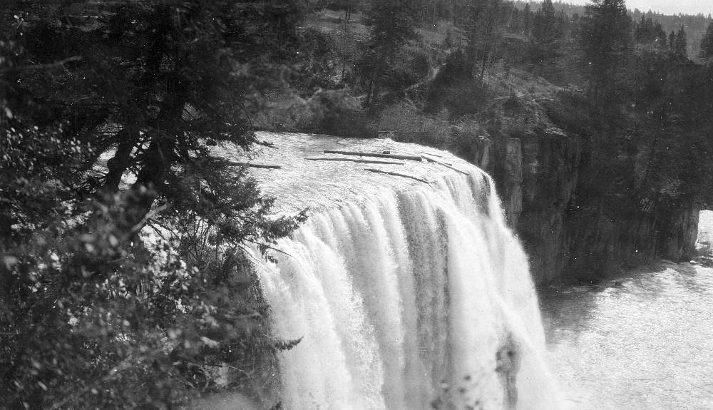
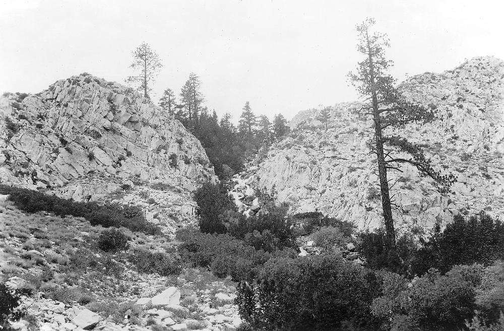
North Fork Falls sits tucked into the high country of Wyoming’s Teton National Forest, managed by the U.S. Forest Service. Nestled in a remote stretch of the North Fork of the Snake River and within reach of the small communities of Kelly, Dubois, and Alta, the falls are at their most dramatic during spring and early summer snowmelt. Expect a peaceful, forested setting with the steady roar of cascading water and plenty of opportunities for photography and wildlife viewing in a quieter corner of the forest. Access to the falls is most commonly made via the USFS North Buffalo Fork Trail (Trail #6047). The approach rewards hikers with a short, moderately strenuous outing and an uncrowded feel — a perfect half-day escape for those comfortable with rougher mountain trails. Note that the nearest developed camping is at the Blackrock Ranger District, about 25.5 km away, so come prepared for a remote experience and carry water and emergency supplies.
The Setting
North Fork Falls sits at 8,219 feet within Teton National Forest, in the high alpine of Wyoming.
Trail & Hike Details
The Approach
The moderate hike follows North Buffalo Fork Trail (#6047), a 2.4-mile out-and-back trail over natural surface. Expect 350 feet of elevation gain. The trail is developed (Class 3).
USFS Trail
NORTH BUFFALO FORK TRAIL #6047
Trail Class
Developed
Surface
USFS Segment
9.62 miTrail Description
The most direct route to North Fork Falls uses the USFS North Buffalo Fork Trail, Trail #6047. USFS records show the trail system at roughly 9.62 GIS miles, while typical hiking access to the falls is described as a 2.4-mile out-and-back with about 350 feet of elevation gain (moderate difficulty). The trail surface is native material and the route is rated Class 3, so expect uneven, rocky tread and some scrambling or steeper sections; route-finding can be required in places and conditions vary by season.
What to Expect
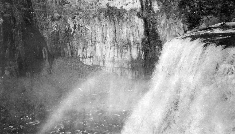
Visitors can expect a peaceful and remote setting with a beautiful waterfall surrounded by Wyoming's rugged wilderness. The area may feature dense forests, rocky terrain, and wildlife sightings.
Accessibility
The trail is not wheelchair accessible. Uneven terrain and elevation changes require steady footing.
Frequently Asked Questions
🐶 Are Dogs Allowed at North Fork Falls?
❌ Dogs are not allowed
Are There Any Fees or Permits Required?
🆖 No fees required
🏊 Is There Swimming at North Fork Falls?
❌ Swimming is not allowed
When to Visit
The best time to visit North Fork Falls is during late spring through early summer when snowmelt enhances the waterfall's flow. Fall offers beautiful foliage, while summer provides warmer weather for exploration.
Seasonal Access
The best time to visit is Spring, Summer, and Fall. Access roads and trails may close during winter due to snow. Check with Teton National Forest for seasonal road closures.
Safety Information
Be cautious of slippery rocks near the waterfall. Wildlife encounters, including bears, are possible, so carry bear spray and make noise while hiking. Weather can change rapidly in this region, so be prepared for sudden storms or temperature drops.
Know when to go.
Get a free email alert when waterfalls near Kelly hit peak flow. We only send when conditions are worth the trip — no weekly newsletters, no spam.
Weather Forecast
Location & Access
Getting There
North Fork Falls is located approximately 38.9 miles from Kelly, 41.7 miles from Dubois, and 48.6 miles from Alta, Wyoming. The coordinates for the waterfall are 43.9802, -110.1199. Access may require driving on unpaved roads and potentially hiking to reach the falls.
Get Directions on Google MapsParking
Parking availability is unclear, but visitors may need to park along nearby roads or at designated trailheads if a trail is required to access the falls.
Elevation
8,219 feet above sea level
Coordinates
43.980226° N, -110.119909° W
Land Management
Managed by USFS
Visitor Tips & Gear
Bring a detailed map or GPS device, as the area may lack clear signage. Wear sturdy hiking boots and prepare for changing weather conditions. Check local reports for road and trail conditions before visiting.
This trail sits at 8,219 ft — the air is noticeably thinner
High AltitudeSome visitors experience headaches, fatigue, or shortness of breath at this elevation. Take it slow, stay hydrated, and consider supplemental oxygen if you're coming from a lower altitude.
As an Amazon Associate, we earn from qualifying purchases.

Coppertone Sport SPF 50 Sunscreen
UV intensity jumps ~4% per 1,000 ft — at this elevation you can burn in half the time.

Sun Bum SPF 30 Lip Balm (3-Pack)
Lips have almost no natural UV protection and burn fast in thin, dry mountain air.

Liquid I.V. Electrolyte Packets
You lose moisture ~2x faster at elevation — electrolytes help you absorb water efficiently.

ROCKNIGHT Polarized UV400 Sunglasses
High-altitude glare off rock and water is intense — UV400 lenses block 99%+ of UVA/UVB.

Boost Oxygen 10L Canister (2-Pack)
Portable supplemental oxygen for quick relief from headaches and shortness of breath.

Altitude Rx OxyBoost Complex
Antioxidant formula designed to support your body's natural altitude acclimation.
As an Amazon Associate, we earn from qualifying purchases.
With 2.4 miles and 350 ft of elevation gain, sturdy boots and trekking poles will help on this moderate trail. Sun exposure on the trail makes good sun protection a must in summer.

Polarized Sunglasses (Knockaround)
Cuts glare off the water so you actually see the falls — and your photos turn out better too.

Columbia Watertight II Rain Jacket
Packs into its own pocket, seam-sealed, and keeps you dry from spray and surprise rain.

Earth Pak Waterproof Dry Bag
Keeps your phone and gear dry when waterfall mist soaks everything else.

Waterproof Phone Pouch (AiRunTech)
Cheap insurance — take photos right next to the falls without killing your phone.

Timberland Euro Sprint Mid Waterproof
Trusted waterproof boot with premium leather and grippy rubber sole — reliable on rocky, wet trails.

TrailBuddy Trekking Poles
Lightweight aluminum, cork grips, and flip-locks that actually hold — a best-seller for good reason.
Where to Stay

Togwotee Mountain Lodge

Headwaters Lodge & Cabins at Flagg Ranch

The Hatchet Resort

Heart Six Ranch
Browse vacation cabins and private rentals nearby
Unique outdoor stays — tents, yurts, and treehouses
Rent a campervan or RV for your waterfall road trip
Some links are affiliate links. We may earn a commission at no extra cost to you.
Nearby Campground
Blackrock Ranger District
15.8 miles away · 0 sites
The Blackrock Ranger District is comprised mostly of the Teton Wilderness. It borders Grand Teton and Yellowstone National Parks. It is home to the headwaters of the Yellowstone River and the Continental Divide.NEW: Teton Division Over Snow Vehicle Use Map October 2016Office hours: 8:00 am - 4:30 pm Monday through FridayBlackrock Ranger DistrictHwy 26/287P.O. Box 278Moran, WY 83013307-543-2386Fax: 307-543-9149
Book on Recreation.govNearby Hot Springs
Hot springs near Kelly, Wyoming

North Buffalo Fork Springs
North Buffalo Fork Springs flows at 113 degrees Fahrenheit—76 degrees above the frigid 36-degree ambient—at 7,420 feet elevatio...
Jackson Lake Hot Springs
Jackson Lake Hot Springs emerges at 162 degrees Fahrenheit along Jackson Lake's northwestern shore in Grand Teton National Park...

Butte Springs
Butte Springs discharges water at 187 degrees Fahrenheit, making it one of Yellowstone's hotter thermal features accessible via...
Turbid Springs
Turbid Springs reaches 198°F at 7,858 feet elevation in Yellowstone National Park, requiring a 2.5-kilometer hike from the East...

Unnamed Spring Gallatin County 1
This unnamed thermal feature flows at 95°F in Yellowstone's remote eastern backcountry at 7,895 feet elevation, located over 5....

Steamboat Springs
Steamboat Springs erupts at 198 degrees Fahrenheit just 12 meters from the East Entrance Road in Yellowstone National Park at 7...
Looking for a soak after your hike? Explore more hot springs near Kelly, Wyoming on SoakingSprings.
Explore Wyoming springsAdditional Information
Nearby Attractions
Nearby attractions include Grand Teton National Park, Bridger-Teton National Forest, and the town of Jackson, Wyoming.
Wildlife
The area is home to diverse wildlife, including deer, elk, moose, and possibly bears. Visitors should practice bear safety and carry bear spray.
Cities near North Fork Falls
Nearby Waterfalls
Other waterfalls named North Fork Falls
5 other waterfalls share this name across the U.S.
Writing about North Fork Falls? Embed this waterfall on your site for free.