Photo Credits (5)
Difficulty
Easy
Trail Length
2.5 miles
Trail Type
Out And Back
Elevation Gain
300 ft
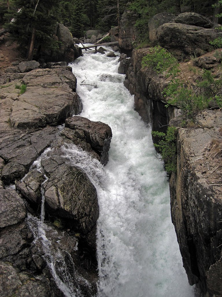
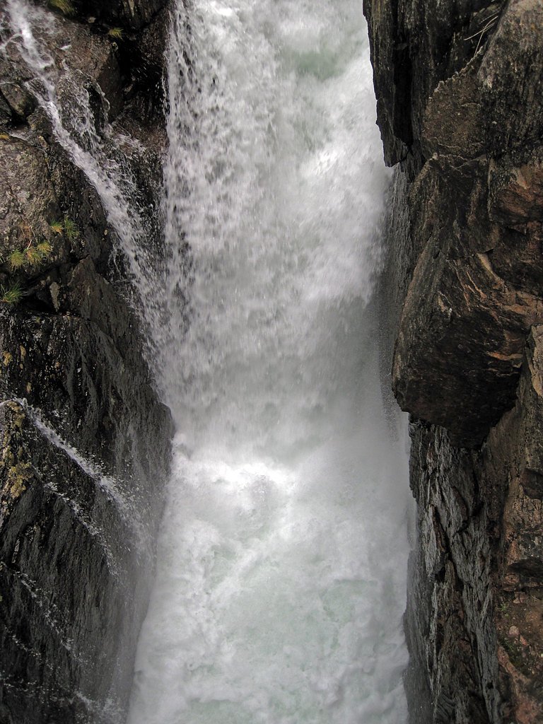
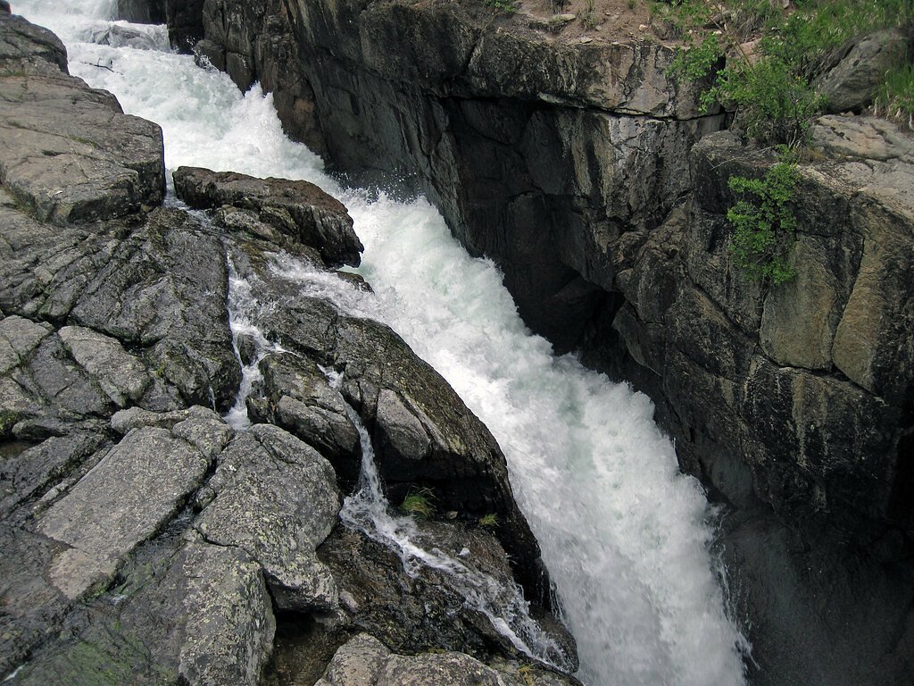
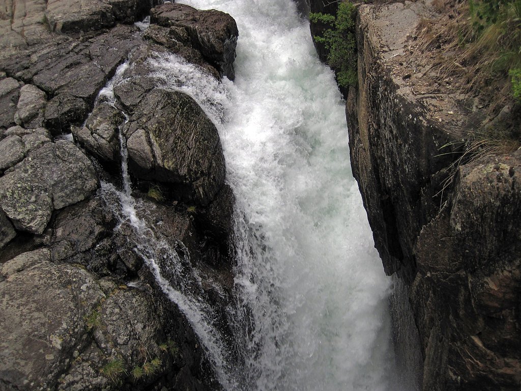
About Lake Fork Falls
Lake Fork Falls is a scenic cascade tucked into the high-country of Teton National Forest, managed by the U.S. Forest Service. The falls sit along Lake Fork Creek amid rugged peaks and dense conifer stands, offering a compact alpine setting that’s ideal for a short nature escape and photos of rushing water framed by forest. The most common approach follows the USFS Lake Creek Trail (Trail #6062). While Forest Service GIS records list Trail #6062 at 5.38 miles, the popular out-and-back route to the falls is roughly 2.5 miles round-trip with about 300 feet of elevation gain and an easy difficulty rating. The short hike rewards visitors with creekside views, meadow openings and a mellow alpine atmosphere—great for families and day hikers looking for a low-effort adventure in Teton National Forest.
The Setting
Lake Fork Falls sits at 9,209 feet within Teton National Forest, in the high alpine of Wyoming.
Trail & Hike Details
The Approach
The easy hike follows Lake Creek (#6062), a 2.5-mile out-and-back trail over natural surface. Expect 300 feet of elevation gain. The trail is moderately developed (Class 2).
USFS Trail
LAKE CREEK #6062
Trail Class
Moderately Developed
Surface
USFS Segment
5.38 miTrail Description
Follow the USFS Lake Creek Trail (Trail #6062) on an easy out-and-back route to Lake Fork Falls. The trail is Class 2 and primarily packed on native material surface; USFS GIS maps show Trail #6062 at 5.38 miles, though the common hike to the falls is about 2.5 miles round-trip. Expect gentle grades totaling roughly 300 feet of elevation gain, well-defined tread, and creek-side stretches—suitable for most hikers and casual day trips.
What to Expect
Dogs are welcome.
Accessibility
The trail is not wheelchair accessible. Uneven terrain and elevation changes require steady footing.
Frequently Asked Questions
🐶 Are Dogs Allowed at Lake Fork Falls?
✅ Dogs are allowed
Are There Any Fees or Permits Required?
🆖 No fees required
🏊 Is There Swimming at Lake Fork Falls?
❌ Swimming is not allowed
When to Visit
The best time to visit is late spring through early fall when the trail is free of snow and the waterfall flow is at its peak due to snowmelt.
Seasonal Access
The best time to visit is Spring, Summer, and Fall. Access roads and trails may close during winter due to snow. Check with Teton National Forest for seasonal road closures.
Safety Information
Be prepared for changing weather conditions, as the area can experience sudden storms. Carry bear spray and know how to use it. Stay on the trail to avoid damaging the environment and for your safety.
Know when to go.
Get a free email alert when waterfalls near Dubois hit peak flow. We only send when conditions are worth the trip — no weekly newsletters, no spam.
Weather Forecast
Location & Access
Getting There
Lake Fork Falls is accessed via the Lake Fork Trailhead, located off the Beartooth Highway (US-212). The trailhead is well-marked and provides access to the trail leading to the falls.
Get Directions on Google MapsParking
Parking is available at the Lake Fork Trailhead. The lot is moderately sized but may fill up during peak seasons.
Elevation
9,209 feet above sea level
Coordinates
43.931895° N, -109.962680° W
Land Management
Managed by USFS
Visitor Tips & Gear
Wear sturdy footwear as the trail may be muddy or slippery in some sections, especially after rain. Bring insect repellent during the summer months to protect against mosquitoes. Arrive early to secure parking, particularly during weekends and holidays.
This trail sits at 9,209 ft — the air is noticeably thinner
High AltitudeSome visitors experience headaches, fatigue, or shortness of breath at this elevation. Take it slow, stay hydrated, and consider supplemental oxygen if you're coming from a lower altitude.
As an Amazon Associate, we earn from qualifying purchases.

Coppertone Sport SPF 50 Sunscreen
UV intensity jumps ~4% per 1,000 ft — at this elevation you can burn in half the time.

Sun Bum SPF 30 Lip Balm (3-Pack)
Lips have almost no natural UV protection and burn fast in thin, dry mountain air.

Liquid I.V. Electrolyte Packets
You lose moisture ~2x faster at elevation — electrolytes help you absorb water efficiently.

ROCKNIGHT Polarized UV400 Sunglasses
High-altitude glare off rock and water is intense — UV400 lenses block 99%+ of UVA/UVB.

Boost Oxygen 10L Canister (2-Pack)
Portable supplemental oxygen for quick relief from headaches and shortness of breath.

Altitude Rx OxyBoost Complex
Antioxidant formula designed to support your body's natural altitude acclimation.
As an Amazon Associate, we earn from qualifying purchases.
This easy 2.5 miles hike is straightforward — comfortable trail shoes and plenty of water should do. Sun exposure on the trail makes good sun protection a must in summer.

Polarized Sunglasses (Knockaround)
Cuts glare off the water so you actually see the falls — and your photos turn out better too.

Columbia Watertight II Rain Jacket
Packs into its own pocket, seam-sealed, and keeps you dry from spray and surprise rain.

Earth Pak Waterproof Dry Bag
Keeps your phone and gear dry when waterfall mist soaks everything else.

Waterproof Phone Pouch (AiRunTech)
Cheap insurance — take photos right next to the falls without killing your phone.

JOBY GorillaPod Starter Kit
Wraps around railings and rocks for long-exposure waterfall shots — no flat surface needed.

Osprey Daylite Daypack
Light, organized, and just the right size for a day hike — fits water, snacks, and layers.
Where to Stay


Browse vacation cabins and private rentals nearby
Unique outdoor stays — tents, yurts, and treehouses
Rent a campervan or RV for your waterfall road trip
Some links are affiliate links. We may earn a commission at no extra cost to you.
Nearby Campground
Pinnacles Campground
12.4 miles away · 0 sites
This campground hosts 21 campsites with dramatic views near Brooks Lake. Angling and flyfishing opportunities are nearby, with a boat ramp at Brooks Lake. Fantastic geologic formations at Pinnacle Butte can be seen on the drive in to the campground. Maximum spur 32 feet.Picnic tables, fire rings, bear boxes, and garbage collection are available.This site is not accessible to those with mobility impairments.
Book on Recreation.govNearby Hot Springs
Hot springs near Dubois, Wyoming

North Buffalo Fork Springs
North Buffalo Fork Springs flows at 113 degrees Fahrenheit—76 degrees above the frigid 36-degree ambient—at 7,420 feet elevatio...
Geyser (Warm Spring Creek Springs)
This thermal feature produces 84-degree Fahrenheit water on Bureau of Land Management lands at 7,260 feet elevation, emerging i...
Jackson Lake Hot Springs
Jackson Lake Hot Springs emerges at 162 degrees Fahrenheit along Jackson Lake's northwestern shore in Grand Teton National Park...
Little Warm Spring
Little Warm Spring discharges at 77 degrees Fahrenheit just 42 meters from Three Spear Ranch Access Road at 7,403 feet elevatio...
Kendall Warm Spring
Kendall Warm Spring emerges at 86 degrees with pH 7.8 and high sulfate content (650 mg/L) at 7,820 feet in Bridger National For...
Jakeys Fork Spring
Jakeys Fork Spring emerges at 68 degrees Fahrenheit at 7,176 feet elevation in Sublette County near Pinedale, located 540 feet ...
Looking for a soak after your hike? Explore more hot springs near Dubois, Wyoming on SoakingSprings.
Explore Wyoming springsAdditional Information
Nearby Attractions
Nearby attractions include the Beartooth Highway, Island Lake, and the Absaroka-Beartooth Wilderness.
Wildlife
The area is home to a variety of wildlife, including deer, elk, and birds. Be cautious of bears and carry bear spray as this is bear country.
Cities near Lake Fork Falls
Nearby Waterfalls
Writing about Lake Fork Falls? Embed this waterfall on your site for free.