North Fork Falls
By Armen Suny · Last verified May 2026
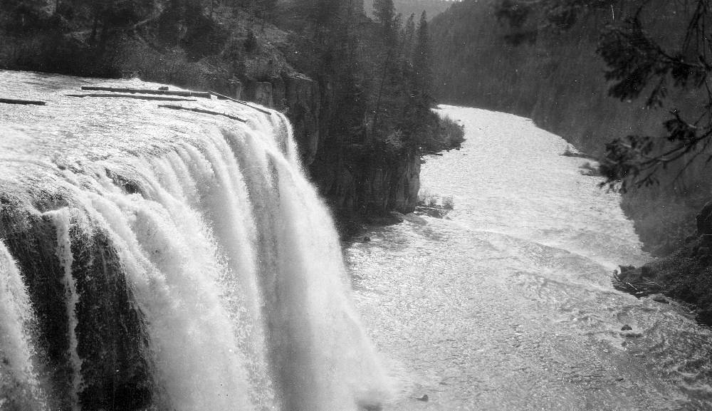
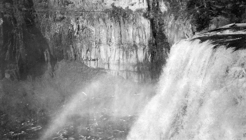
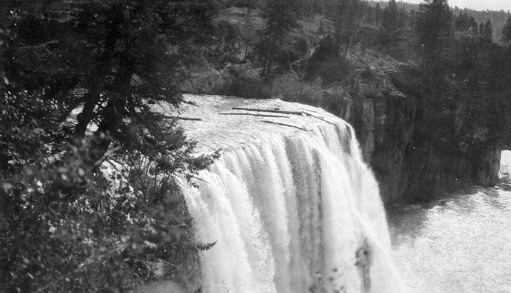
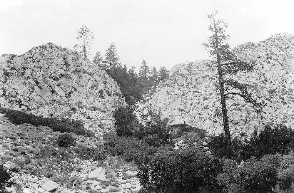
Photo Credits (5)
Difficulty
Moderate
Trail Length
2.5 miles
Trail Type
Out And Back
Elevation Gain
400 ft
About North Fork Falls
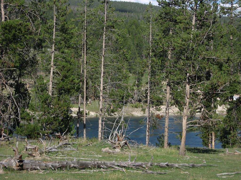
North Fork Falls is a quietly scenic waterfall tucked into Wyoming’s Bridger National Forest, managed by the U.S. Forest Service. The falls are most commonly reached via the USFS Ethel Lake Trail (Trail #7164), making for a peaceful half-day outing through spruce and mixed-wood forest. The typical hike to the falls is an out-and-back of about 2.5 miles with roughly 400 feet of elevation gain and is generally rated moderate — a satisfying option for hikers who enjoy a short climb and a rewarding water feature at the end. The route follows USFS-maintained singletrack (ETHEL LAKE Trail #7164) that the Forest Service records at a GIS length of 4.55 miles; the section to the falls is the shorter spur most day-hikers use. If you want to camp nearby, Large Vehicle Campground is roughly 6.75 km away, giving you an easy base for an overnight stay in the national forest.
The Setting
North Fork Falls sits at 8,606 feet within Bridger National Forest, fed by the Boulder Creek, in the high alpine of Wyoming.
Trail & Hike Details
The Approach
The moderate hike follows Ethel Lake (#7164), a 2.5-mile out-and-back trail over natural surface. Expect 400 feet of elevation gain. The trail is developed (Class 3).
USFS Trail
ETHEL LAKE #7164
Trail Class
Developed
Surface
USFS Segment
4.55 miTrail Description
Route: Follows USFS Ethel Lake Trail (ETHEL LAKE, Trail #7164; GIS length 4.55 miles). Typical hike to North Fork Falls: out-and-back ~2.5 miles total, 400 ft elevation gain, difficulty: moderate. Surface: NATIVE MATERIAL. USFS class: 3. Trail type: out-and-back. Expect natural singletrack tread with native-surface footing and a mix of gentle inclines and short moderate climbs; sections can be uneven due to roots and native rock. (No formal grade percentage provided in USFS data.)
What to Expect
Dogs are welcome.
Accessibility
The trail is not wheelchair accessible. Uneven terrain and elevation changes require steady footing.
Frequently Asked Questions
🐶 Are Dogs Allowed at North Fork Falls?
✅ Dogs are allowed
Are There Any Fees or Permits Required?
🆖 No fees required
🏊 Is There Swimming at North Fork Falls?
❌ Swimming is not allowed
When to Visit
The best time to visit is during late spring through early fall when the trail is most accessible, and the waterfall flow is typically at its peak.
Seasonal Access
The best time to visit is Spring, Summer, and Fall. Access roads and trails may close during winter due to snow. Check with Bridger National Forest for seasonal road closures.
Safety Information
Hikers should be prepared for changing weather conditions and carry appropriate gear. The trail may be slippery after rain or snow. Wildlife encounters are possible, so remain vigilant and follow safety guidelines.
Current Water Conditions
477 ft³/s
Current discharge — how much water is flowing
Much lower than usual for this time of year
Based on 3 years of record
4.00 ft
Water depth at gauge
7-Day Discharge Trend
What does this mean for your visit?
Flow is well below normal for this time of year, so the waterfall may be a trickle.
About This Gauge
7-Day Flow Outlook
Based on the USGS gauge Boulder Creek above Boulder Lake, near Boulder, WY (7 km away).
Today
Low
544 cfs
3/10Tomorrow
Low
571 cfs
3/10Fri
Low
602 cfs
3/10Sat
Low
621 cfs
3/10Sun
Low
598 cfs
4/10Mon
Low
566 cfs
3/10Tue
Barely Flowing
426 cfs
5/10Best window: Tue — barely flowing flow, sunny (trip score 5/10).
Best time of year: this gauge typically runs highest from late April to mid July, peaking in May.
How we calculate this
This is a transparent outlook, not a precise forecast. We take the waterfall's current flow strength (how it ranks against its historical normal for today, from the nearest USGS stream gauge), carry that ranking forward along the gauge's seasonal curve, and nudge it for forecast rain. Confidence is highest for the next day or two and falls further out. Always check official conditions and your own judgment before visiting — high flows can be dangerous.
Know when to go.
Get a free email alert when waterfalls near Boulder hit peak flow. We only send when conditions are worth the trip — no weekly newsletters, no spam.
Weather Forecast
Location & Access
Getting There
North Fork Falls is located in the Bridger-Teton National Forest, Wyoming. The trailhead can typically be accessed via forest service roads, but conditions may vary depending on the season. It is recommended to check with the local ranger station for the most up-to-date access information.
Get Directions on Google MapsParking
Parking is available near the trailhead, but spaces may be limited during peak seasons. Visitors should plan to arrive early to secure a spot.
Elevation
8,606 feet above sea level
Coordinates
42.873542° N, -109.528746° W
Land Management
Managed by USFS
Visitor Tips & Gear
Wear sturdy hiking shoes as the trail may have uneven terrain. Bring plenty of water, especially during warmer months. Arrive early to avoid crowds and secure parking. Check weather conditions before heading out, as the trail may be slippery after rain or snow.
This trail sits at 8,606 ft — the air is noticeably thinner
High AltitudeSome visitors experience headaches, fatigue, or shortness of breath at this elevation. Take it slow, stay hydrated, and consider supplemental oxygen if you're coming from a lower altitude.
As an Amazon Associate, we earn from qualifying purchases.

Coppertone Sport SPF 50 Sunscreen
UV intensity jumps ~4% per 1,000 ft — at this elevation you can burn in half the time.

Sun Bum SPF 30 Lip Balm (3-Pack)
Lips have almost no natural UV protection and burn fast in thin, dry mountain air.

Liquid I.V. Electrolyte Packets
You lose moisture ~2x faster at elevation — electrolytes help you absorb water efficiently.

ROCKNIGHT Polarized UV400 Sunglasses
High-altitude glare off rock and water is intense — UV400 lenses block 99%+ of UVA/UVB.

Boost Oxygen 10L Canister (2-Pack)
Portable supplemental oxygen for quick relief from headaches and shortness of breath.

Altitude Rx OxyBoost Complex
Antioxidant formula designed to support your body's natural altitude acclimation.
As an Amazon Associate, we earn from qualifying purchases.
With 2.5 miles and 400 ft of elevation gain, sturdy boots and trekking poles will help on this moderate trail. Sun exposure on the trail makes good sun protection a must in summer.

Polarized Sunglasses (Knockaround)
Cuts glare off the water so you actually see the falls — and your photos turn out better too.

Columbia Watertight II Rain Jacket
Packs into its own pocket, seam-sealed, and keeps you dry from spray and surprise rain.

Earth Pak Waterproof Dry Bag
Keeps your phone and gear dry when waterfall mist soaks everything else.

Waterproof Phone Pouch (AiRunTech)
Cheap insurance — take photos right next to the falls without killing your phone.

Timberland Euro Sprint Mid Waterproof
Trusted waterproof boot with premium leather and grippy rubber sole — reliable on rocky, wet trails.

TrailBuddy Trekking Poles
Lightweight aluminum, cork grips, and flip-locks that actually hold — a best-seller for good reason.
Where to Stay

Gannett Peak Lodge

Lakeside Lodge Resort and Marina

Sundance Motel

Boulder Inn
Browse vacation cabins and private rentals nearby
Unique outdoor stays — tents, yurts, and treehouses
Rent a campervan or RV for your waterfall road trip
Some links are affiliate links. We may earn a commission at no extra cost to you.
Nearby Campground
Large Vehicle Campground
4.2 miles away · 0 sites
The Large Vehicle Campground located within Scab Creek Recreation Area provides 7 campsites for those wishing to camp with packs stock, trailers, large RV's or campers. There are corrals provided in the campground for pack stock. Vault toilette and potable water can be found up the road at the pack stock staging area, also within the Scab Creek Recreation Area.
Book on Recreation.govNearby Hot Springs
Hot springs near Boulder, Wyoming
Steele Hot Springs
Steele Hot Springs flows at 102 degrees Fahrenheit near Pinedale in Sublette County at 7,065 feet elevation, accessible via a 1...
Jakeys Fork Spring
Jakeys Fork Spring emerges at 68 degrees Fahrenheit at 7,176 feet elevation in Sublette County near Pinedale, located 540 feet ...
Washakie Mineral Hot Springs
Washakie Mineral Hot Springs flows at 111°F on the Wind River Reservation in Fremont County, delivering moderately hot water 68...
Little Warm Spring
Little Warm Spring discharges at 77 degrees Fahrenheit just 42 meters from Three Spear Ranch Access Road at 7,403 feet elevatio...
Kendall Warm Spring
Kendall Warm Spring emerges at 86 degrees with pH 7.8 and high sulfate content (650 mg/L) at 7,820 feet in Bridger National For...
Geyser (Warm Spring Creek Springs)
This thermal feature produces 84-degree Fahrenheit water on Bureau of Land Management lands at 7,260 feet elevation, emerging i...
Looking for a soak after your hike? Explore more hot springs near Boulder, Wyoming on SoakingSprings.
Explore Wyoming springsAdditional Information
Nearby Attractions
Other attractions in the Bridger-Teton National Forest include hiking trails, scenic viewpoints, and opportunities for wildlife viewing.
Wildlife
The area is home to a variety of wildlife, including deer, elk, and birds. Visitors should be cautious of bears and carry bear spray as a precaution.
Cities near North Fork Falls
Other waterfalls named North Fork Falls
5 other waterfalls share this name across the U.S.
Writing about North Fork Falls? Embed this waterfall on your site for free.