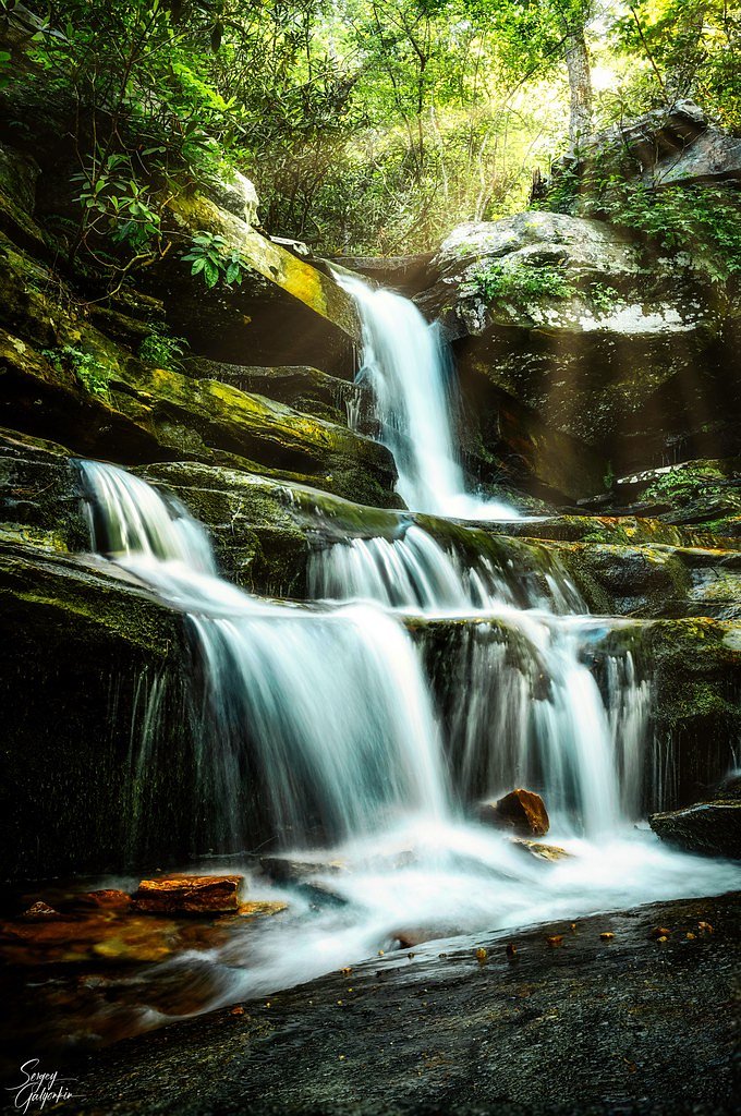
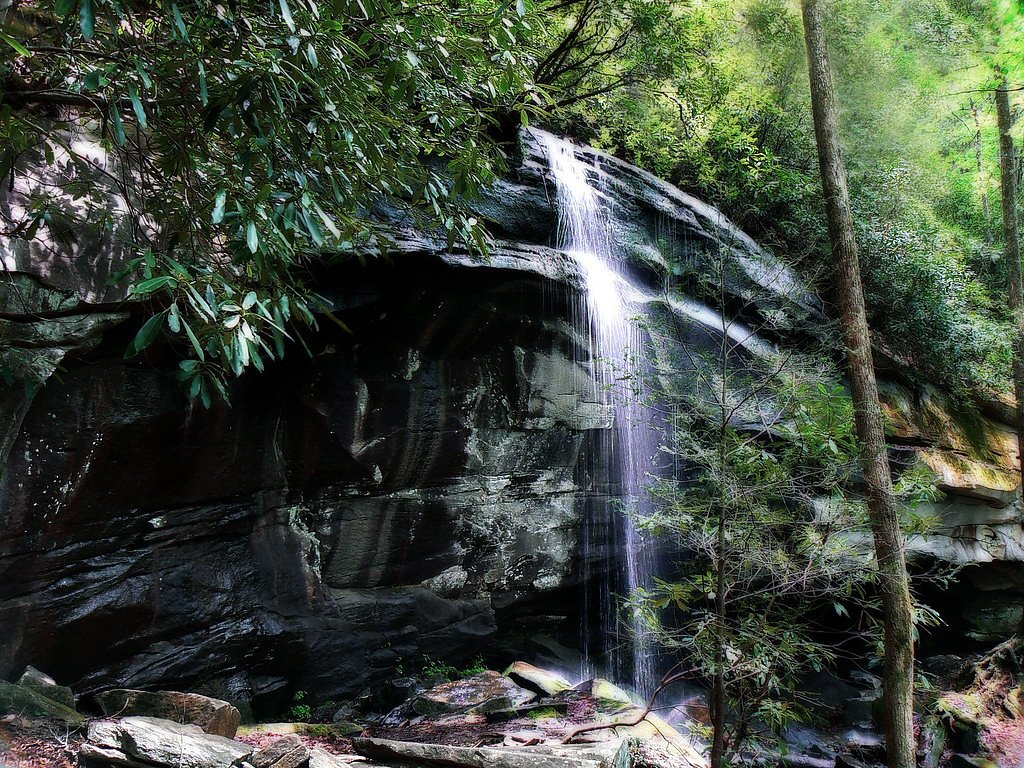
Laughing Falls
By Armen Suny · Last verified May 2026


Photo Credits (4)
Difficulty
Moderate
Trail Length
2.4 miles
Trail Type
Out And Back
Elevation Gain
350 ft
About Laughing Falls
Laughing Falls sits tucked inside Pisgah National Forest in North Carolina and is managed by the U.S. Forest Service. The falls are a quietly picturesque cascade set among forested slopes, making it a popular short outing for hikers and photographers wanting a peaceful stop amid classic Pisgah woodlands. The hike to the falls is an approachable adventure — an out-and-back route of about 2.4 miles with roughly 350 feet of elevation gain and a moderate difficulty rating. Access to Laughing Falls uses USFS routing, including a short stretch along GRASSY ROAD (USFS Trail TR364). That designated segment is recorded as a 0.08-mile portion of native-material tread and is classed by the Forest Service as Class 3. If you’re planning an overnight, the Black Mountain / South Toe River Area campground is nearby (about 2.23 km), making it convenient to combine this stop with a campsite in Pisgah National Forest.
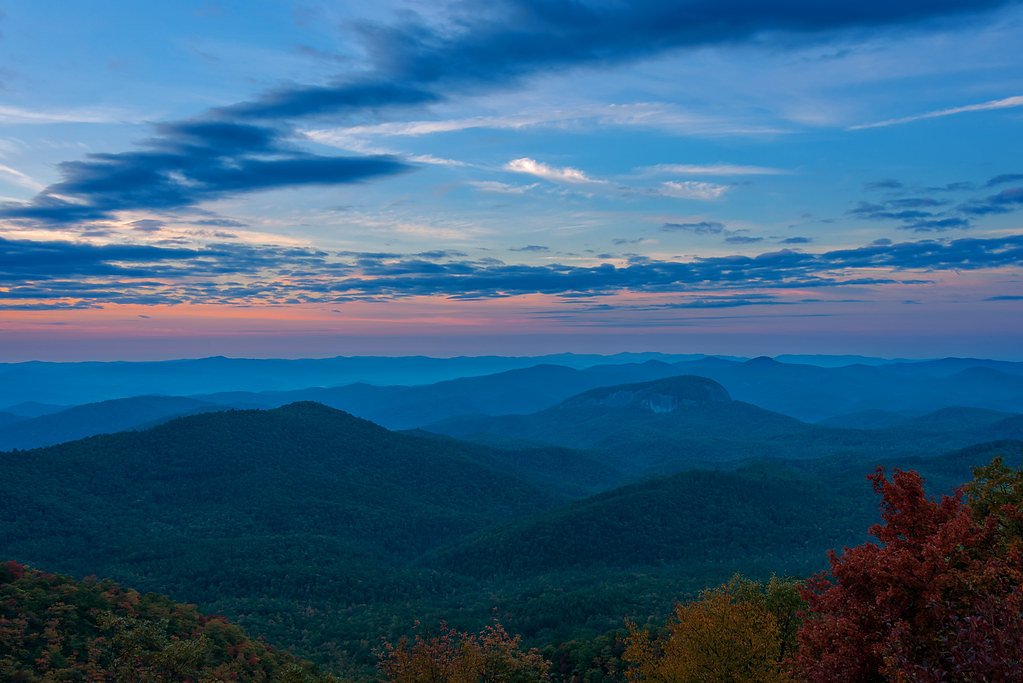
The Setting
Laughing Falls sits at 2,365 feet within Pisgah National Forest, fed by the Davidson River, in the hills of North Carolina.
Nearby Falls Worth Visiting
High Falls (150 ft) lies 4.2 miles to the northwest. Also nearby: Looking Glass Falls (60 ft, 3.7 mi) and Slick Rock Falls (30 ft, 5.4 mi).
Trail & Hike Details
The Approach
The moderate hike follows Grassy Road (#TR364), a 2.4-mile out-and-back trail over natural surface. Expect 350 feet of elevation gain. The trail is developed (Class 3).
USFS Trail
GRASSY ROAD #TR364
Trail Class
Developed
Surface
USFS Segment
0.08 miTrail Description
Out-and-back, approximately 2.4 miles round-trip with about 350 feet of cumulative elevation gain; rated moderate. The route follows native-material tread (USFS surface: NATIVE MATERIAL) and includes a short USFS-designated segment — GRASSY ROAD, Trail #TR364 — listed at 0.08 miles and Class 3 by the Forest Service. Expect natural dirt tread with intermittent rocky or uneven sections and occasional roots; the Class 3 section may feel rougher and more rooted underfoot. Good hiking footwear and basic trail experience are recommended.
What to Expect
Visitors can expect a tranquil waterfall surrounded by dense greenery. The area is ideal for photography, picnics, and enjoying the sounds of nature. The trail may be muddy after rain, so proper footwear is recommended.
Accessibility
The trail is not wheelchair accessible. Uneven terrain and elevation changes require steady footing.
Frequently Asked Questions
🐶 Are Dogs Allowed at Laughing Falls?
❌ Dogs are not allowed
Are There Any Fees or Permits Required?
🆖 No fees required
🏊 Is There Swimming at Laughing Falls?
❌ Swimming is not allowed
When to Visit
Spring and early summer are ideal for visiting Laughing Falls, as the water flow is typically strongest during these seasons.
Seasonal Access
The best time to visit is Spring, Summer, and Fall. Winter access may be limited. Check with Pisgah National Forest for seasonal road closures.
Safety Information
Visitors should exercise caution on slippery rocks near the waterfall and be aware of changing weather conditions. Carry a map or GPS device, as cell service may be limited.
Current Water Conditions
42 ft³/s
Current discharge — how much water is flowing
Much lower than usual for this time of year
Based on 102 years of record
0.61 ft
Water depth at gauge
74°F
ComfortablePleasant for swimming
7-Day Discharge Trend
What does this mean for your visit?
Flow is well below normal for this time of year, so the waterfall may be a trickle. The water is a comfortable 74 degrees F, pleasant for swimming.
About This Gauge
7-Day Flow Outlook
Based on the USGS gauge DAVIDSON RIVER NEAR BREVARD, NC (2 km away).
Today
Low
47 cfs
3/10Tomorrow
Moderate
49 cfs
4/10Wed
Moderate
49 cfs
4/10Thu
Moderate
47 cfs
4/10Fri
Moderate
47 cfs
4/10Sat
Moderate
44 cfs
4/10Sun
Moderate
44 cfs
4/10Best window: Tomorrow — moderate flow, sunny then chance showers and thunderstorms (trip score 4/10).
Best time of year: this gauge typically runs highest from mid February to late April, peaking in March.
How we calculate this
This is a transparent outlook, not a precise forecast. We take the waterfall's current flow strength (how it ranks against its historical normal for today, from the nearest USGS stream gauge), carry that ranking forward along the gauge's seasonal curve, and nudge it for forecast rain. Confidence is highest for the next day or two and falls further out. Always check official conditions and your own judgment before visiting — high flows can be dangerous.
Know when to go.
Get a free email alert when waterfalls near Brevard hit peak flow. We only send when conditions are worth the trip — no weekly newsletters, no spam.
Weather Forecast
Location & Access
Getting There
Laughing Falls is located within a forested area in North Carolina. Specific directions may vary depending on the trailhead used, so it is recommended to consult local maps or AllTrails for the most accurate route.
Get Directions on Google MapsParking
Parking availability is not well-documented, but visitors may find parking near the trailhead. It is advisable to arrive early, especially during peak seasons.
Elevation
2,365 feet above sea level
Coordinates
35.294836° N, -82.701792° W
Land Management
Managed by USFS
Visitor Tips & Gear
Start your hike early to avoid crowds and ensure you have enough daylight for the return trip. Bring plenty of water and snacks, and wear sturdy hiking shoes. Check weather conditions before your visit.
As an Amazon Associate, we earn from qualifying purchases.
With 2.4 miles and 350 ft of elevation gain, sturdy boots and trekking poles will help on this moderate trail. Sun exposure on the trail makes good sun protection a must in summer.

Polarized Sunglasses (Knockaround)
Cuts glare off the water so you actually see the falls — and your photos turn out better too.

Columbia Watertight II Rain Jacket
Packs into its own pocket, seam-sealed, and keeps you dry from spray and surprise rain.

Earth Pak Waterproof Dry Bag
Keeps your phone and gear dry when waterfall mist soaks everything else.

Waterproof Phone Pouch (AiRunTech)
Cheap insurance — take photos right next to the falls without killing your phone.

Timberland Euro Sprint Mid Waterproof
Trusted waterproof boot with premium leather and grippy rubber sole — reliable on rocky, wet trails.

TrailBuddy Trekking Poles
Lightweight aluminum, cork grips, and flip-locks that actually hold — a best-seller for good reason.
Where to Stay

Hampton Inn Brevard

Comfort Inn & Suites Brevard North

Holiday Inn Express - Brevard by IHG

Pilot Cove
Browse vacation cabins and private rentals nearby
Unique outdoor stays — tents, yurts, and treehouses
Rent a campervan or RV for your waterfall road trip
Some links are affiliate links. We may earn a commission at no extra cost to you.
Nearby Campground
Black Mountain / South Toe River Area
1.4 miles away · 0 sites
The South Toe River area is on the Appalachian Ranger District near Burnsville, NC. This area includes the Black Mountains, the Blue Ridge, and the headwaters of the South Toe River. The Black Mountains, capped with a forest of red spruce and Fraser fir, are named for the resulting dark color. Along the South Toe River, you can camp, picnic, fish, swim, tube, bike, and horseback ride.
Book on Recreation.govNearby Hot Springs
Hot springs near Brevard, North Carolina

Looking for a soak after your hike? Explore more hot springs near Brevard, North Carolina on SoakingSprings.
Explore North Carolina springsAdditional Information
Nearby Attractions
Nearby attractions may include other waterfalls, hiking trails, and scenic viewpoints in the surrounding area.
Wildlife
The area is home to a variety of wildlife, including birds, deer, and small mammals. Be cautious of snakes and other potentially hazardous animals.
Cities near Laughing Falls
Nearby Waterfalls

Other waterfalls named Laughing Falls
1 other waterfall shares this name across the U.S.
Writing about Laughing Falls? Embed this waterfall on your site for free.