Great Falls
By Armen Suny · Last verified May 2026
Difficulty
Moderate
Trail Length
2.4 miles
Trail Type
Out And Back
Elevation Gain
350 ft
About Great Falls
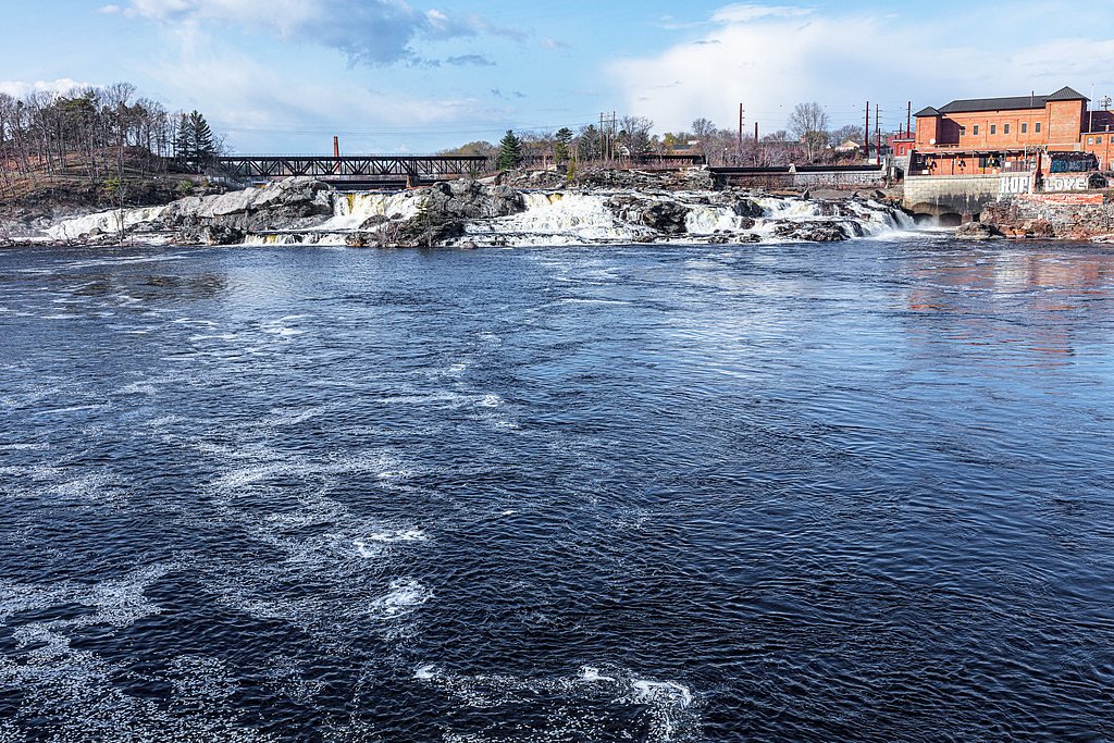
Great Falls sits on the Androscoggin River in Lewiston–Auburn, Maine, and offers a broad, powerful cascade that has long been part of the area's industrial story—historically harnessed as a power source for local mills. The falls are especially dramatic during spring runoff and after heavy rains, when higher flows accentuate the drop and reveal the river’s raw energy. Visitors often come for quick roadside views, photography, or to appreciate an important piece of local landscape and history. Beyond the easy viewing areas, hikers can explore a short route that lets you take in more of the river corridor. An out-and-back hike of 2.4 miles with roughly 350 feet of elevation gain is rated moderate and provides a more immersive way to experience the falls and surrounding riverside terrain. There is no USFS trail name or number associated with this route; access typically begins from nearby parking and viewing points, making Great Falls a flexible destination for both casual sightseers and hikers looking for a brief, rewarding outing.
The Setting
Great Falls sits at 312 feet along the Saco River, in the coastal lowlands of Maine.
Trail & Hike Details
The Approach
The moderate 2.4-mile out-and-back trail gains 350 feet of elevation on the way to the falls.
Trail Description
Route type: out-and-back. Distance: 2.4 miles round trip. Elevation gain: about 350 feet. Difficulty: moderate. Access: primary access is from roadside parking and viewing areas on the Lewiston–Auburn stretch of the Androscoggin River; the 2.4-mile hike departs from these access points. There is no formal U.S. Forest Service trail designation or published USFS trail number for this route. Hikers should expect an informal path that leaves from the parking/viewing areas and may include uneven riverbank terrain; wear sturdy footwear and plan for a short, moderately strenuous hike to get a closer look at the falls.
What to Expect
Dogs are welcome.
Accessibility
The trail is not wheelchair accessible. Uneven terrain and elevation changes require steady footing.
Frequently Asked Questions
🐶 Are Dogs Allowed at Great Falls?
✅ Dogs are allowed
Are There Any Fees or Permits Required?
🆖 No fees required
🏊 Is There Swimming at Great Falls?
❌ Swimming is not allowed
When to Visit
Spring is the best time to visit due to high water flow from snowmelt. Fall offers beautiful foliage views, while summer provides a pleasant atmosphere for a casual visit.
Seasonal Access
The best time to visit is Spring, Summer, and Fall. Winter access may be limited.
Safety Information
Exercise caution near the riverbanks, especially during high water flow. The currents can be strong and dangerous.
Current Water Conditions
4,350 ft³/s
Current discharge — how much water is flowing
Much higher than usual for this time of year
Based on 110 years of record
5.44 ft
Water depth at gauge
7-Day Discharge Trend
What does this mean for your visit?
The water is flowing much higher than usual, expect an impressive display.
About This Gauge
7-Day Flow Outlook
Based on the USGS gauge Saco River at Cornish, Maine (5 km away).
Today
Low
4959 cfs
3/10Tomorrow
Low
4472 cfs
5/10Sun
Low
4829 cfs
3/10Mon
Low
4594 cfs
6/10Tue
Low
4637 cfs
4/10Wed
Low
4808 cfs
4/10Thu
Low
4831 cfs
3/10Best window: Mon — low flow, mostly sunny (trip score 6/10).
Best time of year: this gauge typically runs highest from mid March to early June, peaking in April.
How we calculate this
This is a transparent outlook, not a precise forecast. We take the waterfall's current flow strength (how it ranks against its historical normal for today, from the nearest USGS stream gauge), carry that ranking forward along the gauge's seasonal curve, and nudge it for forecast rain. Confidence is highest for the next day or two and falls further out. Always check official conditions and your own judgment before visiting — high flows can be dangerous.
Know when to go.
Get a free email alert when waterfalls near Cornish hit peak flow. We only send when conditions are worth the trip — no weekly newsletters, no spam.
Weather Forecast
Location & Access
Getting There
Great Falls is easily accessible from downtown Lewiston or Auburn. The falls can be viewed from the Great Falls Plaza area or from nearby walking paths along the river.
Get Directions on Google MapsParking
Parking is available at Great Falls Plaza in Auburn, which offers convenient access to viewing areas.
Elevation
312 feet above sea level
Coordinates
43.852574° N, -70.796729° W
Visitor Tips & Gear
Visit during spring or after heavy rains for the most impressive water flow. Bring a camera to capture the scenic views. Be cautious near the riverbanks, as water levels can rise quickly.
As an Amazon Associate, we earn from qualifying purchases.
With 2.4 miles and 350 ft of elevation gain, sturdy boots and trekking poles will help on this moderate trail. Sun exposure on the trail makes good sun protection a must in summer.

Polarized Sunglasses (Knockaround)
Cuts glare off the water so you actually see the falls — and your photos turn out better too.

Columbia Watertight II Rain Jacket
Packs into its own pocket, seam-sealed, and keeps you dry from spray and surprise rain.

Earth Pak Waterproof Dry Bag
Keeps your phone and gear dry when waterfall mist soaks everything else.

Waterproof Phone Pouch (AiRunTech)
Cheap insurance — take photos right next to the falls without killing your phone.

Timberland Euro Sprint Mid Waterproof
Trusted waterproof boot with premium leather and grippy rubber sole — reliable on rocky, wet trails.

TrailBuddy Trekking Poles
Lightweight aluminum, cork grips, and flip-locks that actually hold — a best-seller for good reason.
Where to Stay

Noble House Inn

Comfort Inn & Suites North Conway

LILY OF THE VALLEY LIMIT 6

ROCKY BEACH LIMIT 5 cabin
Browse vacation cabins and private rentals nearby
Unique outdoor stays — tents, yurts, and treehouses
Rent a campervan or RV for your waterfall road trip
Some links are affiliate links. We may earn a commission at no extra cost to you.
Nearby Campground
Saco Ranger District
18.9 miles away · 0 sites
Located on the south eastern part of the forest, the District offers a variety of different recreational opportunities. Journey across the Kancamagus Scenic Byway; experience the famous Mt Chocorua area; find solitude in the Presidential Range-Dry River or Sandwich Wildernesses; or discover the beauty along Scenic Route 113. Recreational opportunities are endless: hiking, camping, hiking, biking, fishing, skiing (alpine, cross country, and backcountry), snowmobiling, snowshoeing and much more.
Book on Recreation.govAdditional Information
Nearby Attractions
The Lewiston-Auburn Riverwalk offers additional scenic views and walking paths. The Bates Mill Complex and Museum L-A are also nearby for those interested in local history.
Wildlife
Birdwatchers may spot various waterfowl and other birds near the river.
Cities near Great Falls
Other waterfalls named Great Falls
12 other waterfalls share this name across the U.S.
Writing about Great Falls? Embed this waterfall on your site for free.