
Photo Credits (4)
Difficulty
Moderate
Trail Length
2.4 miles
Trail Type
Out And Back
Elevation Gain
350 ft
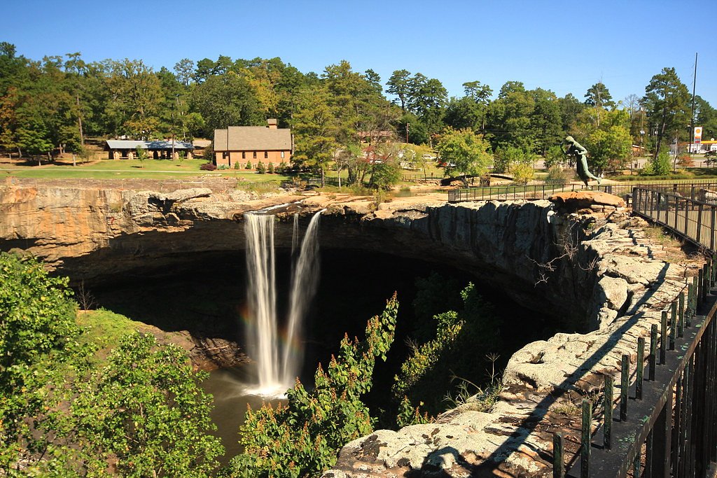
About Great Falls
Great Falls sits just outside Smiths Station, Alabama, and rewards visitors with a quiet, leafy setting where water threads through rock and timber. This lesser-known cascade is framed by lush greenery and feels like a private escape—perfect for photographers and anyone seeking a short, scenic outing away from busier parks. The approach is compact but satisfying: a roughly 2.4-mile round trip that climbs about 350 feet, so the payoff at the falls comes after a bit of steady hiking. Plan for a moderate outing—the trail is an out-and-back and suits hikers who don’t mind some uphill work and uneven footing. Bring sturdy shoes, water, and a camera; the path winds through typical Alabama woods and offers close-up views of the falls that make the moderate effort worthwhile.
The Setting
Great Falls sits at 351 feet along the Uchee Creek, in the coastal lowlands of Alabama.
Trail & Hike Details
The Approach
The moderate 2.4-mile out-and-back trail gains 350 feet of elevation on the way to the falls.
Trail Description
Trail length: 2.4 miles round trip (out-and-back). Elevation gain: approximately 350 feet. Difficulty: moderate. Official managing agency or USFS trail number/name is not provided for this route. Surface and technical specs are not formally documented; hikers should expect a natural dirt trail with uneven footing and some short, moderately steep sections. Good hiking shoes and basic navigation awareness are recommended for the return trek.
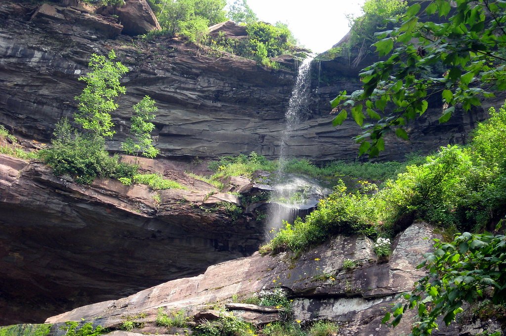
What to Expect
Visitors can expect a serene natural setting with a waterfall surrounded by forested areas. The flow of the waterfall may vary depending on recent rainfall.
Accessibility
The trail is not wheelchair accessible. Uneven terrain and elevation changes require steady footing.
Frequently Asked Questions
🐶 Are Dogs Allowed at Great Falls?
❌ Dogs are not allowed
Are There Any Fees or Permits Required?
🆖 No fees required
🏊 Is There Swimming at Great Falls?
❌ Swimming is not allowed
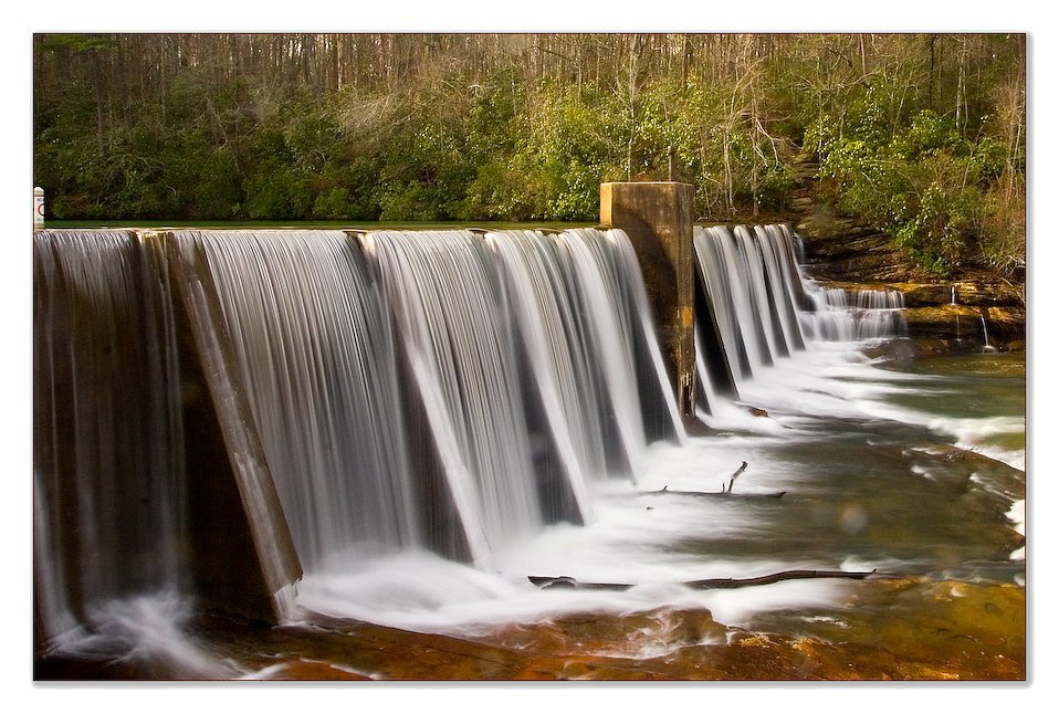
When to Visit
Spring and fall are typically the best times to visit, as the weather is mild and the waterfall may have a stronger flow due to seasonal rains.
Seasonal Access
The best time to visit is Spring, Summer, Fall, and Winter.
Safety Information
Visitors should exercise caution when exploring the area, as trails may be uneven or slippery. Be aware of potential hazards such as loose rocks and wildlife.
Current Water Conditions
Based on a USGS gauge 16.5 miles away
142 ft³/s
Current discharge — how much water is flowing
About average for this time of year
Based on 79 years of record
1.34 ft
Water depth at gauge
7-Day Discharge Trend
What does this mean for your visit?
Flow is about average for this time of year.
About This Gauge
This gauge is on a regional waterway. Conditions at the falls may differ, especially after local rain.
7-Day Flow Outlook
Based on the USGS gauge UCHEE CREEK NEAR FORT MITCHELL, AL. (27 km away).
Today
Low
162 cfs
3/10Tomorrow
Low
157 cfs
3/10Thu
Barely Flowing
140 cfs
5/10Fri
Barely Flowing
124 cfs
5/10Sat
Low
127 cfs
3/10Sun
Low
154 cfs
3/10Mon
Low
161 cfs
3/10Best window: Thu — barely flowing flow, sunny (trip score 5/10).
Best time of year: this gauge typically runs highest from mid January to mid April, peaking in March.
How we calculate this
This is a transparent outlook, not a precise forecast. We take the waterfall's current flow strength (how it ranks against its historical normal for today, from the nearest USGS stream gauge), carry that ranking forward along the gauge's seasonal curve, and nudge it for forecast rain. Confidence is highest for the next day or two and falls further out. Always check official conditions and your own judgment before visiting — high flows can be dangerous.
Know when to go.
Get a free email alert when waterfalls near Smiths Station hit peak flow. We only send when conditions are worth the trip — no weekly newsletters, no spam.
Weather Forecast
Location & Access
Getting There
Great Falls is located approximately 4.7 miles from Smiths Station, 6.4 miles from Ladonia, and 9.2 miles from Phenix City. The coordinates for the waterfall are 32.5087, -85.1842. Access to the site may require navigating local roads, and visitors should confirm directions before traveling.
Get Directions on Google MapsParking
Parking availability is unclear. Visitors are advised to check local resources or contact nearby authorities for guidance.
Elevation
351 feet above sea level
Coordinates
32.508715° N, -85.184222° W
Visitor Tips & Gear
Check weather conditions before visiting, as the waterfall's flow may depend on recent rain. Bring water and snacks, and wear sturdy shoes for exploring the area.
As an Amazon Associate, we earn from qualifying purchases.
With 2.4 miles and 350 ft of elevation gain, sturdy boots and trekking poles will help on this moderate trail. Icy conditions are common in winter — traction cleats are a smart addition.

Columbia Watertight II Rain Jacket
Packs into its own pocket, seam-sealed, and keeps you dry from spray and surprise rain.

Polarized Sunglasses (Knockaround)
Cuts glare off the water so you actually see the falls — and your photos turn out better too.

Earth Pak Waterproof Dry Bag
Keeps your phone and gear dry when waterfall mist soaks everything else.

Waterproof Phone Pouch (AiRunTech)
Cheap insurance — take photos right next to the falls without killing your phone.

Timberland Euro Sprint Mid Waterproof
Trusted waterproof boot with premium leather and grippy rubber sole — reliable on rocky, wet trails.

TrailBuddy Trekking Poles
Lightweight aluminum, cork grips, and flip-locks that actually hold — a best-seller for good reason.
Where to Stay

stayAPT Suites Columbus-Fort Benning

Holiday Inn Express Phenix City-Fort Benning by IHG

Microtel Inn and Suites by Wyndham

Microtel Inn & Suites Columbus North
Browse vacation cabins and private rentals nearby
Unique outdoor stays — tents, yurts, and treehouses
Rent a campervan or RV for your waterfall road trip
Some links are affiliate links. We may earn a commission at no extra cost to you.
Nearby Campground
BLUFF CREEK
24.8 miles away · 87 sites
Overview Bluff Creek Campground is situated on the shores of Walter F. George Lake on the Georgia and Alabama border. The lake is a great place to get away for a week, a weekend or just an afternoon. Boating, swimming, fishing and camping are popular activities. Click here for a virtual tour of the many facilities at Walter F. George Lake.Recreation The Chattahoochie River lakes are an angler's paradise, where largemouth bass, white bass, hybrids, crappie, channel catfish and bream are found. The
Book on Recreation.govNearby Hot Springs
Hot springs near Smiths Station, Alabama

Warm Springs
Warm Springs delivers 88°F water, 24 degrees above ambient, within F.D. Roosevelt State Park—Georgia's most thermally impressiv...
Parkman Spring
Parkman Spring maintains a comfortable 77°F temperature, 13 degrees above ambient, and requires a short woodland walk in Meriwe...
Tom Brown Spring
Tom Brown Spring maintains 68°F, barely 4 degrees above ambient, and sits roadside in Meriwether County near Manchester.
Thundering Spring
Thundering Spring flows 75°F water, 11 degrees above ambient, in Upson County near Hannahs Mill, requiring a moderate woodland ...
Barker Spring
Barker Spring maintains 73°F water, a modest 9 degrees above the regional ambient in Georgia's Piedmont, where it emerges roads...
Lifsey Spring
Lifsey Spring delivers 79°F water, 15 degrees above ambient, making it one of Georgia's more noticeably warm thermal springs in...
Looking for a soak after your hike? Explore more hot springs near Smiths Station, Alabama on SoakingSprings.
Explore Alabama springsAdditional Information
Nearby Attractions
Nearby attractions include Smiths Station, Ladonia, and Phenix City, which offer dining and shopping options.
Wildlife
The area may feature local wildlife such as birds, deer, and small mammals. Visitors should be cautious of snakes and other potentially hazardous animals.
Cities near Great Falls
Other waterfalls named Great Falls
12 other waterfalls share this name across the U.S.
Writing about Great Falls? Embed this waterfall on your site for free.