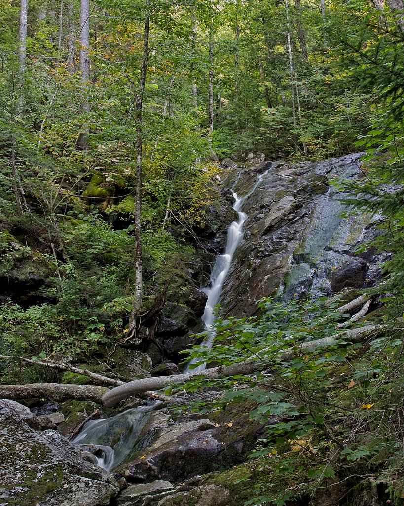
Fletcher Cascades
By Armen Suny · Last verified Mar 2026
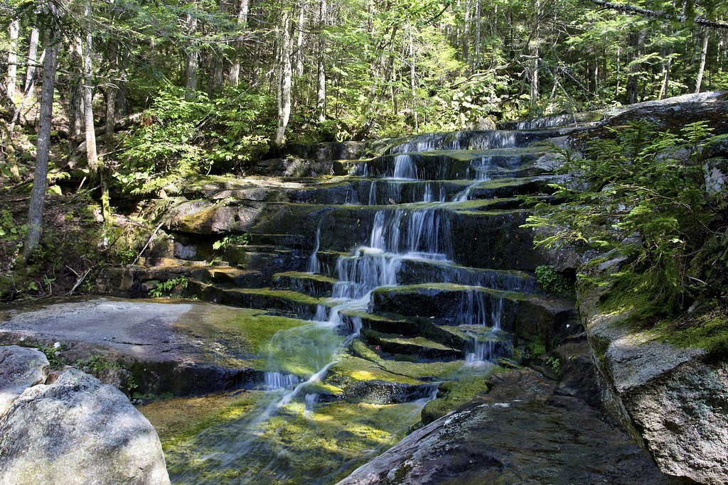
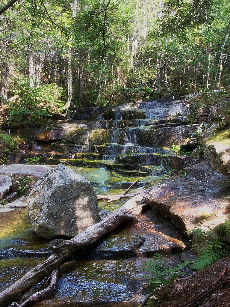
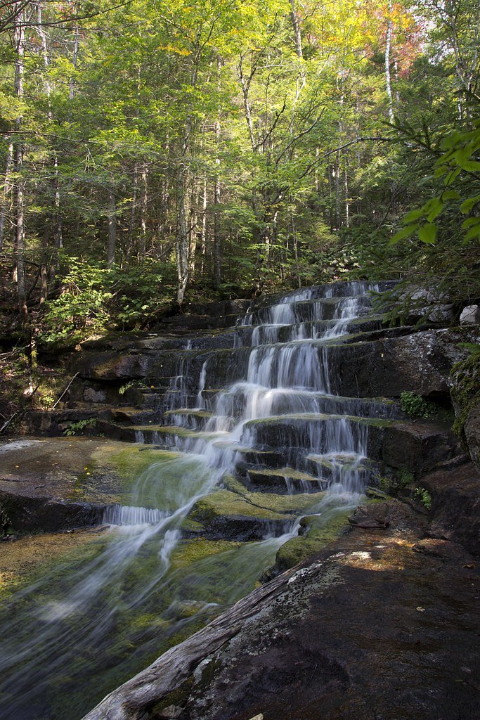
Photo Credits (4)
Difficulty
Moderate
Trail Length
3.2 miles
Trail Type
Out And Back
Elevation Gain
600 ft
About Fletcher Cascades
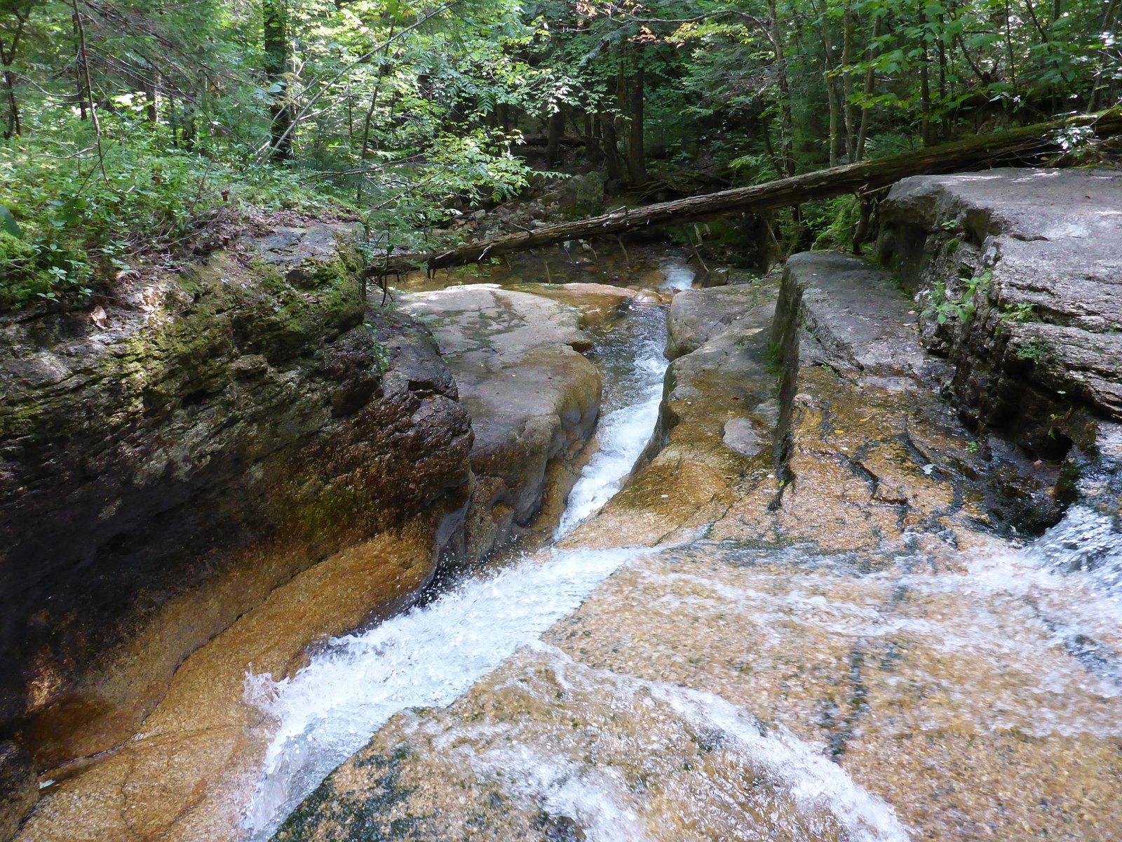
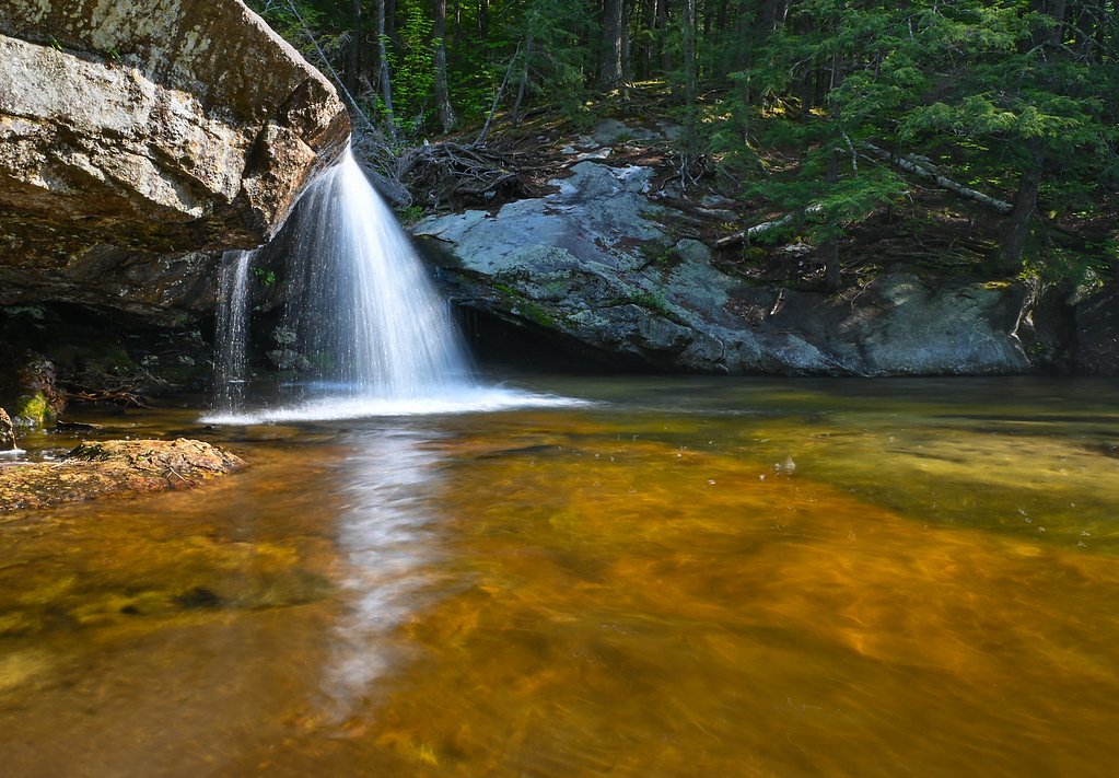
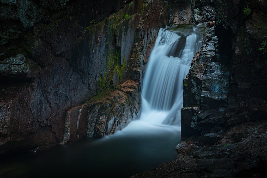
Fletcher Cascades is a picturesque waterfall located in the White Mountains of New Hampshire. It features a series of cascading drops along Drakes Brook, surrounded by lush forest scenery. The falls are particularly beautiful after rainfall or during spring snowmelt.
The Setting
Fletcher Cascades sits at 2,103 feet within White Mountain National Forest, fed by the Pemigewasset River, in the hills of New Hampshire.
Trail & Hike Details
The Approach
The moderate hike follows Fletcher Cascade (#32174), a 3.2-mile out-and-back trail over natural surface. Expect 600 feet of elevation gain with grades of 12-20%. The trail is developed (Class 3).
USFS Trail
FLETCHER CASCADE #32174
Trail Class
Developed
Surface
Avg Grade
USFS Segment
0.28 miTrail Description
The trail to Fletcher Cascades is a moderately challenging out-and-back hike through a forested area. The path follows Drakes Brook and includes some rocky and root-filled sections. The trail is well-maintained and marked, making it easy to follow. The final approach to the cascades involves a slight incline.
What to Expect
Dogs are welcome.
Accessibility
The trail is not wheelchair accessible. Uneven terrain and elevation changes require steady footing.
Frequently Asked Questions
🐶 Are Dogs Allowed at Fletcher Cascades?
✅ Dogs are allowed
Are There Any Fees or Permits Required?
🆖 No fees required
🏊 Is There Swimming at Fletcher Cascades?
❌ Swimming is not allowed
When to Visit
The best time to visit Fletcher Cascades is in the spring or early summer when water flow is at its peak due to snowmelt or after heavy rainfall. Fall is also a great time to visit for the vibrant foliage.
Seasonal Access
The best time to visit is Spring, Summer, and Fall. Winter access may be limited. Check with White Mountain National Forest for seasonal road closures.
Safety Information
The trail can be slippery, especially after rain. Use caution on wet rocks and roots. Be prepared for changing weather conditions, as the area can be cool and damp.
Current Water Conditions
493 ft³/s
Current discharge — how much water is flowing
Higher than usual for this time of year
Based on 62 years of record
3.34 ft
Water depth at gauge
7-Day Discharge Trend
What does this mean for your visit?
The water is flowing higher than usual for this time of year.
About This Gauge
This gauge is on a nearby waterway and may not reflect exact conditions at the falls.
7-Day Flow Outlook
Based on the USGS gauge PEMIGEWASSET RIVER AT WOODSTOCK, NH (16 km away).
Today
Barely Flowing
538 cfs
3/10Tomorrow
Barely Flowing
496 cfs
5/10Tue
Barely Flowing
509 cfs
3/10Wed
Low
488 cfs
3/10Thu
Barely Flowing
476 cfs
5/10Fri
Low
436 cfs
3/10Sat
Low
434 cfs
4/10Best window: Tomorrow — barely flowing flow, sunny (trip score 5/10).
Best time of year: this gauge typically runs highest from late March to mid June, peaking in May.
How we calculate this
This is a transparent outlook, not a precise forecast. We take the waterfall's current flow strength (how it ranks against its historical normal for today, from the nearest USGS stream gauge), carry that ranking forward along the gauge's seasonal curve, and nudge it for forecast rain. Confidence is highest for the next day or two and falls further out. Always check official conditions and your own judgment before visiting — high flows can be dangerous.
Know when to go.
Get a free email alert when waterfalls near Center Sandwich hit peak flow. We only send when conditions are worth the trip — no weekly newsletters, no spam.
Weather Forecast
Location & Access
Getting There
Fletcher Cascades is accessed via the Drakes Brook Trailhead, located off Route 49 in Waterville Valley, New Hampshire. The trailhead is well-marked and has a small parking area.
Get Directions on Google MapsParking
Parking is available at the Drakes Brook Trailhead. The lot is small, so arriving early is recommended, especially during peak seasons.
Elevation
2,103 feet above sea level
Coordinates
43.930626° N, -71.487853° W
Land Management
Managed by USFS
Visitor Tips & Gear
Wear sturdy footwear as the trail can be rocky and uneven in places. Bring bug spray during the summer months, as mosquitoes and black flies can be present. Arrive early to secure parking, especially on weekends.
As an Amazon Associate, we earn from qualifying purchases.
With 3.2 miles and 600 ft of elevation gain, sturdy boots and trekking poles will help on this moderate trail. Sun exposure on the trail makes good sun protection a must in summer.

Polarized Sunglasses (Knockaround)
Cuts glare off the water so you actually see the falls — and your photos turn out better too.

Columbia Watertight II Rain Jacket
Packs into its own pocket, seam-sealed, and keeps you dry from spray and surprise rain.

Earth Pak Waterproof Dry Bag
Keeps your phone and gear dry when waterfall mist soaks everything else.

Waterproof Phone Pouch (AiRunTech)
Cheap insurance — take photos right next to the falls without killing your phone.

Timberland Euro Sprint Mid Waterproof
Trusted waterproof boot with premium leather and grippy rubber sole — reliable on rocky, wet trails.

TrailBuddy Trekking Poles
Lightweight aluminum, cork grips, and flip-locks that actually hold — a best-seller for good reason.
Where to Stay

1-Bedroom Condo in Thornton

Cozy Ski Condo

The Valley Inn, an Ascend Collection Hotel

Inn 32
Browse vacation cabins and private rentals nearby
Unique outdoor stays — tents, yurts, and treehouses
Rent a campervan or RV for your waterfall road trip
Some links are affiliate links. We may earn a commission at no extra cost to you.
Nearby Campground
WATERVILLE CAMPGROUND
1.3 miles away · 29 sites
Overview Waterville Campground is a popular home base for hikers who want to explore the southern White Mountains, including the scenic Pemigewasset Wilderness. The tremendous choice of local attractions and the proximity to outdoor recreation opportunities - fishing, swimming, hiking and whitewater paddling to name a few - bring campers back to Waterville again and again. The White Mountains boast pristine forests, clear mountain streams and rivers and the tallest peaks in the Northeast. The for
Book on Recreation.govAdditional Information
Nearby Attractions
Nearby attractions include Waterville Valley Resort, the Welch-Dickey Loop Trail, and the Sandwich Dome hike.
Wildlife
The area is home to a variety of wildlife, including birds, squirrels, and occasionally deer. Be cautious of ticks and other insects.
Cities near Fletcher Cascades
Nearby Waterfalls
Writing about Fletcher Cascades? Embed this waterfall on your site for free.