
Deception Falls
By Armen Suny · Last verified Mar 2026
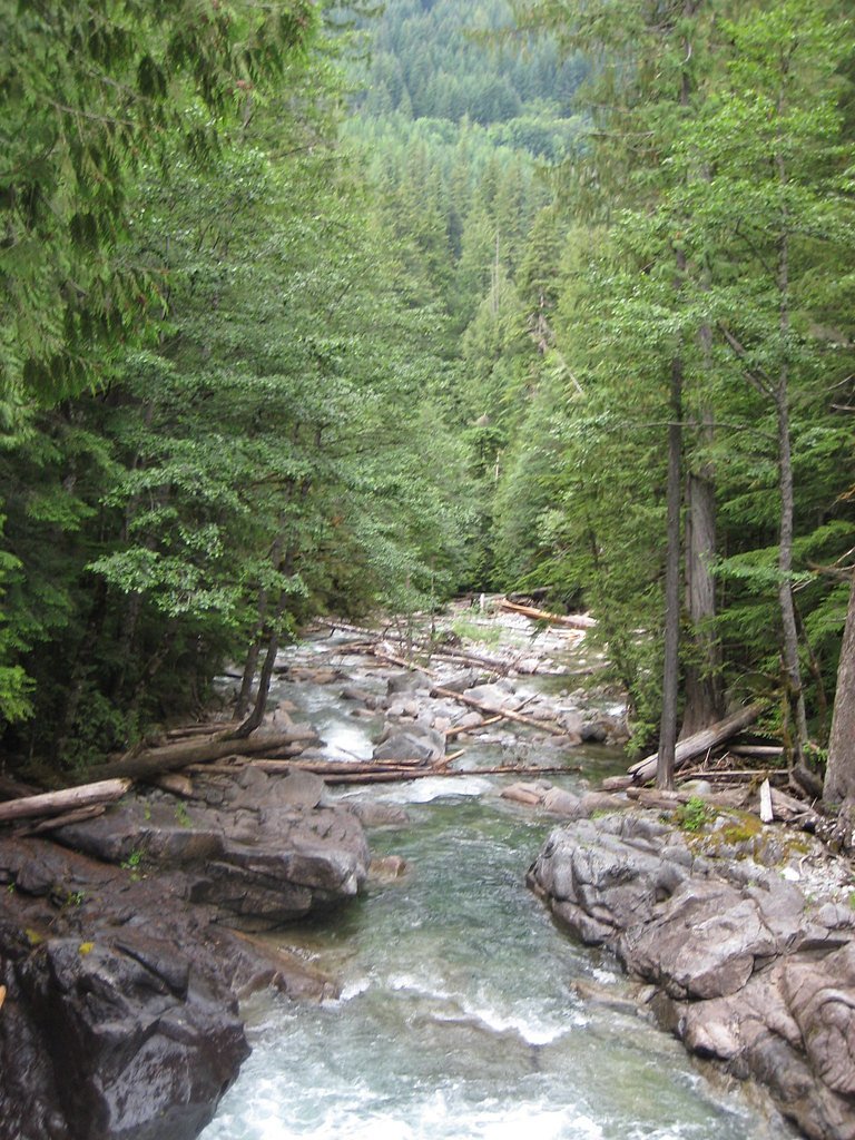
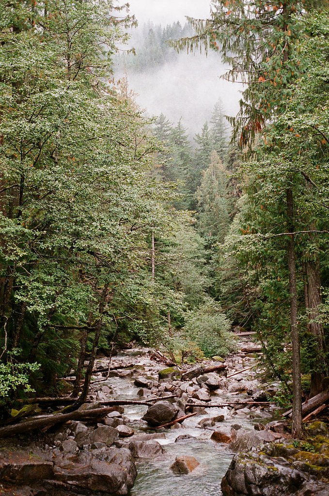
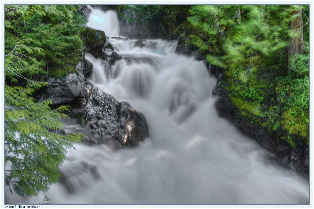
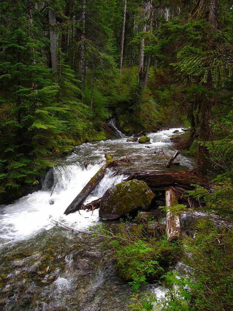
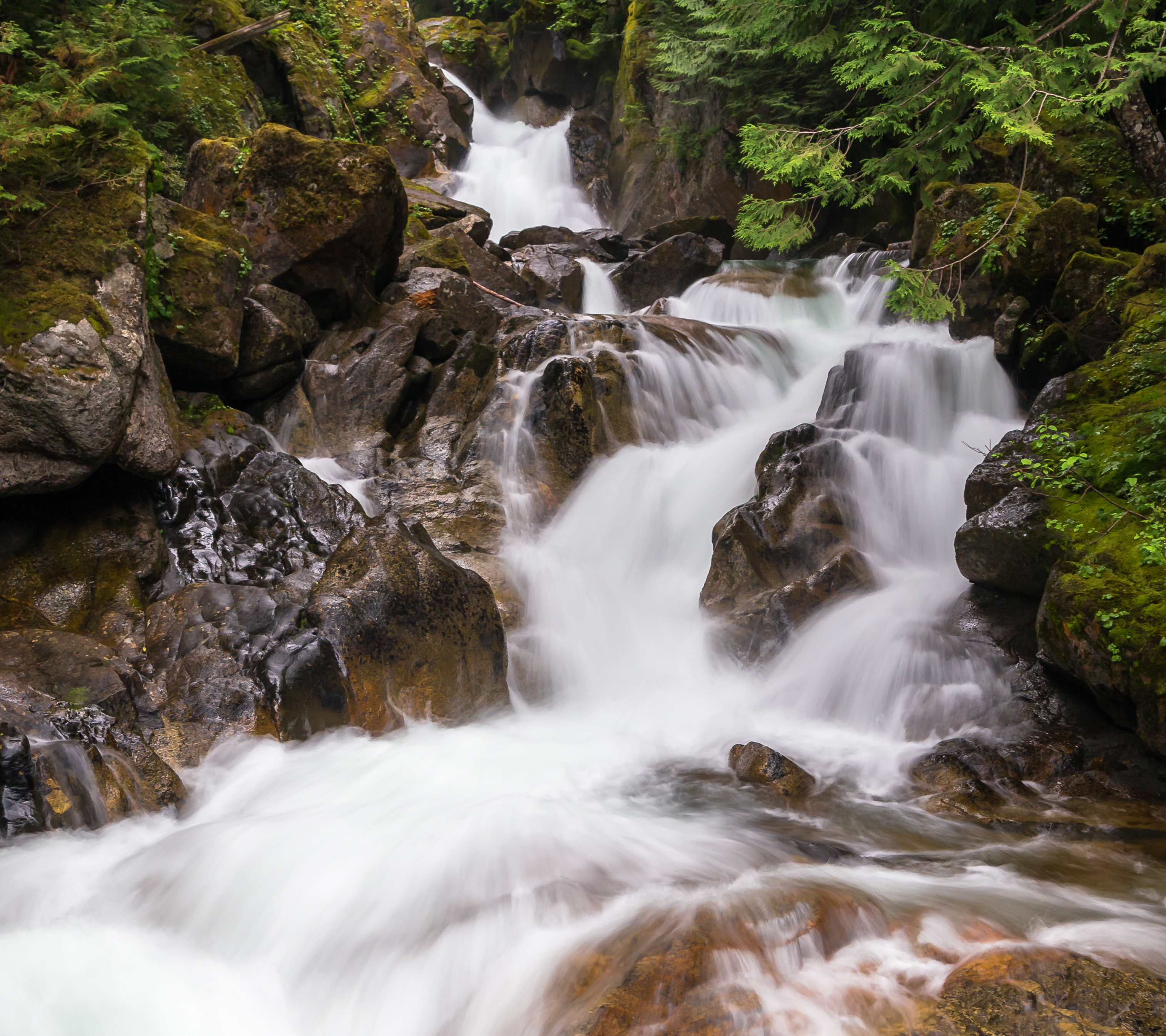
Photo Credits (5)
Difficulty
Easy
Trail Length
0.5 miles
Trail Type
Loop
Elevation Gain
50 ft
About Deception Falls
Deception Falls is a picturesque waterfall located in the Mount Baker-Snoqualmie National Forest in Washington. It is known for its cascading waters and lush surrounding forest, making it a popular stop for travelers along Highway 2.
The Setting
Deception Falls sits at 1,890 feet within Snoqualmie National Forest, fed by the South Fork Skykomish River, in the hills of Washington.
Trail & Hike Details
The Approach
The easy hike follows Deception Falls (#1078), a 0.5-mile loop trail over pavement. Expect 50 feet of elevation gain with grades of 12-20%. The trail is fully developed (Class 5).
USFS Trail
DECEPTION FALLS #1078
Trail Class
Fully Developed
Surface
Avg Grade
USFS Segment
0.06 miTrail Description
The Deception Falls trail is a short and easy loop that takes visitors through a lush forest and offers multiple viewpoints of the falls. The trail is well-maintained and includes interpretive signs about the area's natural features.
What to Expect
Dogs are welcome.
Accessibility
The trail is paved and may be accessible to wheelchairs and strollers. Contact the managing agency to confirm current conditions.
Frequently Asked Questions
🐶 Are Dogs Allowed at Deception Falls?
✅ Dogs are allowed
Are There Any Fees or Permits Required?
🆖 No fees required
🏊 Is There Swimming at Deception Falls?
❌ Swimming is not allowed
When to Visit
Spring and early summer are ideal times to visit, as the waterfall is at its fullest due to snowmelt. Fall offers beautiful foliage, while winter may provide a quieter experience if accessible.
Seasonal Access
The best time to visit is Spring, Summer, and Fall. Winter access may be limited. Check with Snoqualmie National Forest for seasonal road closures.
Safety Information
Exercise caution near the water, as the rocks can be slippery and the currents are strong. Check weather conditions before visiting, as heavy rain or snow can make the trail hazardous.
Current Water Conditions
660 ft³/s
Current discharge — how much water is flowing
Lower than usual for this time of year
Based on 9 years of record
18.05 ft
Water depth at gauge
7-Day Discharge Trend
What does this mean for your visit?
Flow is lower than usual for this time of year.
About This Gauge
This gauge is on a nearby waterway and may not reflect exact conditions at the falls.
7-Day Flow Outlook
Based on the USGS gauge SOUTH FORK SKYKOMISH RIVER AT SKYKOMISH, WA (13 km away).
Today
Low
713 cfs
4/10Tomorrow
Low
762 cfs
4/10Mon
Low
677 cfs
4/10Tue
Low
646 cfs
4/10Wed
Low
619 cfs
4/10Thu
Low
615 cfs
4/10Fri
Low
552 cfs
4/10Best window: Today — low flow, light rain (trip score 4/10).
Best time of year: this gauge typically runs highest from mid April to late June, peaking in May.
How we calculate this
This is a transparent outlook, not a precise forecast. We take the waterfall's current flow strength (how it ranks against its historical normal for today, from the nearest USGS stream gauge), carry that ranking forward along the gauge's seasonal curve, and nudge it for forecast rain. Confidence is highest for the next day or two and falls further out. Always check official conditions and your own judgment before visiting — high flows can be dangerous.
Know when to go.
Get a free email alert when waterfalls near Skykomish hit peak flow. We only send when conditions are worth the trip — no weekly newsletters, no spam.
Weather Forecast
Location & Access
Getting There
Deception Falls is located off Highway 2, approximately 9 miles east of Skykomish, Washington. The trailhead and parking area are well-marked and easily accessible from the highway.
Get Directions on Google MapsParking
There is a designated parking area near the trailhead, which is free to use. However, parking may be limited during peak seasons.
Elevation
1,890 feet above sea level
Coordinates
47.714554° N, -121.193434° W
Land Management
Managed by USFS
Visitor Tips & Gear
Arrive early during summer weekends to secure parking. Wear sturdy shoes as the trail can be slippery, especially after rain. Bring a camera to capture the beautiful scenery.
As an Amazon Associate, we earn from qualifying purchases.
For this easy 0.5 miles trail, lightweight trail shoes and a water bottle are usually sufficient. Sun exposure on the trail makes good sun protection a must in summer.

Polarized Sunglasses (Knockaround)
Cuts glare off the water so you actually see the falls — and your photos turn out better too.

Columbia Watertight II Rain Jacket
Packs into its own pocket, seam-sealed, and keeps you dry from spray and surprise rain.

Earth Pak Waterproof Dry Bag
Keeps your phone and gear dry when waterfall mist soaks everything else.

Waterproof Phone Pouch (AiRunTech)
Cheap insurance — take photos right next to the falls without killing your phone.

JOBY GorillaPod Starter Kit
Wraps around railings and rocks for long-exposure waterfall shots — no flat surface needed.

Osprey Daylite Daypack
Light, organized, and just the right size for a day hike — fits water, snacks, and layers.
Where to Stay

Luxury A-Frame with Hot Tub, Fireplace & Firepit

Beaver Valley Lodge

FairBridge Inn & Suites Leavenworth

Enzian Inn
Browse vacation cabins and private rentals nearby
Unique outdoor stays — tents, yurts, and treehouses
Rent a campervan or RV for your waterfall road trip
Some links are affiliate links. We may earn a commission at no extra cost to you.
Nearby Campground
Money Creek Campground
10 miles away · 24 sites
Overview Situated on the banks of the South Fork Skykomish River in Mt. Baker-Snoqualmie National Forest, Money Creek campground offers some of the most stunning scenery in the northern Cascade Range in Washington. Scattered beneath a towering canopy of old-growth forest, the sites in this campground are widely spaced and several are at the river's edge, making it an ideal setting for visitors wanting to camp in a private, rustic setting.Recreation In addition to being a prime location for hiking
Book on Recreation.govNearby Hot Springs
Hot springs near Skykomish, Washington
Scenic Hot Springs
Scenic Hot Springs delivers genuinely hot water at 122 degrees Fahrenheit at 2,246 feet elevation in the Cascade Mountains near...
Garland Mineral Springs
Garland Mineral Springs flows at 84 degrees in the Snoqualmie National Forest, producing water 39.6 degrees above ambient tempe...
Goldmeyer Hot Springs
Goldmeyer Hot Springs emerges at 127 degrees in the central Cascades, producing water 78.9 degrees above ambient temperature at...
Kennedy Hot Spring
Kennedy Hot Spring flows at 100 degrees at 3,520 feet elevation in the Mt. Baker National Forest, emerging 58.7 degrees above a...
Gamma Hot Springs
Gamma Hot Springs produces 140-degree water at 5,397 feet elevation in the Mt. Baker National Forest, emerging 104.6 degrees ab...
Sulphur Creek Hot Springs
Sulphur Creek Hot Springs flows at 99 degrees Fahrenheit at 2,973 feet elevation in Mount Baker National Forest's remote backco...
Looking for a soak after your hike? Explore more hot springs near Skykomish, Washington on SoakingSprings.
Explore Washington springsAdditional Information
Nearby Attractions
Nearby attractions include Skykomish, Stevens Pass, and the Iron Goat Trail.
Wildlife
Visitors may encounter birds, squirrels, and other small forest animals. Bears and other larger wildlife are rare but possible in the area.
Cities near Deception Falls
Nearby Waterfalls
Other waterfalls named Deception Falls
1 other waterfall shares this name across the U.S.
Writing about Deception Falls? Embed this waterfall on your site for free.