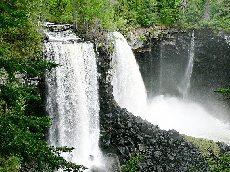
Deception Falls
British Columbia • Wells Gray Park
By Armen Suny · Last verified Jun 2026
Difficulty
Moderate
Trail Length
1.9 km
Trail Type
Out And Back
Elevation Gain
92 m
About Deception Falls
Deception Falls (BC) is a forested, riverine cascade located in central British Columbia. The falls sit on a mountain stream and are set in a mixed-conifer forest typical of the region. Flow and appearance are seasonal, typically higher in spring snowmelt and after heavy rains, lower late-summer. Specific published details about official facilities or developed viewpoints at this coordinate are limited, so descriptions here use cautious language and may not reflect onsite improvements.
The Setting
Deception Falls sits at 786 metres within Wells Gray Park, in the hills of British Columbia.
Why This Waterfall Exists
Deception Falls flows over Slocan Group, a layered sedimentary rock layer deposited about 201-237 million years ago. These soft rocks erode readily, allowing the stream to carve a vertical drop into the landscape.
Nearby Falls Worth Visiting
Canim Falls (25 m) lies 8.4 kilometres to the west. Also nearby: Mahood Falls (20 m, 8.2 km).
Trail & Hike Details
The Approach
The moderate 1.9-km out-and-back trail gains 92 metres of elevation on the way to the falls.
Trail Description
Official trail information is not well-documented for this specific coordinate. Approaches to similar remote cascades in the area are commonly short, single-track or informal footpaths from a roadside pullout to a viewpoint next to the stream, but can also require riverbed scrambling. Expect uneven, possibly steep or rooty terrain close to the water. Use caution near wet rocks and edges.
What to Expect
A natural, wooded stream cascade with variable water flow. Surrounding terrain is typical central-BC forest (conifers, underbrush). There may be limited or no formal infrastructure (no guardrails, restrooms, or interpretive signs). In spring expect higher flow and possibly muddy approaches; in winter expect snow/ice and limited access. Cell reception may be intermittent.
Accessibility
The trail is not wheelchair accessible. Uneven terrain and elevation changes require steady footing.
Frequently Asked Questions
🐶 Are Dogs Allowed at Deception Falls?
❌ Dogs are not allowed
Are There Any Fees or Permits Required?
🆖 No fees required
🏊 Is There Swimming at Deception Falls?
❌ Swimming is not allowed
When to Visit
Late spring (snowmelt) for highest flows and dramatic water; early summer for good access and greenery; early fall for color and stable weather. Avoid periods of heavy rain or rapid snowmelt if you are unprepared for high water or slippery approaches. Early morning or weekdays for fewer visitors.
Seasonal Access
The best time to visit is Spring, Summer, and Fall. Winter access may be limited. Check with Wells Gray Park for current conditions.
Safety Information
Hazards may include slick rocks, steep or unstable edges, fast cold water, and changing road/trail conditions. Winter and shoulder seasons can bring snow and ice that make access dangerous. Always check local conditions, avoid getting too close to the edge, and never enter fast-moving channels. Cell coverage can be unreliable, tell someone your plans and expected return time.
Current Water Conditions
Based on a Water Survey of Canada gauge 40 km away
382.0 m³/s
Current discharge — how much water is flowing
About average for this time of year
Based on 87 years of record
3.70 m
Water depth at gauge
7-Day Discharge Trend
What does this mean for your visit?
Flow is about average for this time of year.
About This Gauge
This gauge is on a regional waterway. Conditions at the falls may differ, especially after local rain.
7-Day Flow Outlook
Based on the WSC gauge CLEARWATER RIVER NEAR CLEARWATER STATION (40 km away).
Today
Moderate
407 m³/s
5/10Tomorrow
Moderate
390 m³/s
8/10Tue
Moderate
373 m³/s
8/10Wed
Moderate
360 m³/s
6/10Thu
Moderate
347 m³/s
6/10Fri
Moderate
366 m³/s
5/10Sat
Moderate
366 m³/s
5/10Best window: Tomorrow — moderate flow, sunny (trip score 8/10).
Best time of year: this gauge typically runs highest from early May to early August, peaking in June.
How we calculate this
This is a transparent outlook, not a precise forecast. We take the waterfall's current flow strength (how it ranks against its historical normal for today, from the nearest WSC stream gauge), carry that ranking forward along the gauge's seasonal curve, and nudge it for forecast rain. Confidence is highest for the next day or two and falls further out. Always check official conditions and your own judgment before visiting — high flows can be dangerous.
Weather Forecast
Location & Access
Getting There
The falls are located near the provided coordinates (51.9036, -120.4865). Access is typically via local forest service or secondary roads off main highways in the region. Visitors should consult up-to-date maps or local tourism/forest service resources for the correct access road. Roads to remote waterfall sites in this part of BC may be unpaved and seasonally gated; a high-clearance vehicle may be advisable.
Get Directions on Google MapsParking
Parking may be limited to a small pullout or informal roadside area. There may not be a formal developed parking lot. Park clear of driveways and keep gates/access points clear. Expect limited signage and no services.
Elevation
786 metres above sea level
Coordinates
51.903639° N, -120.486473° W
Land Management
Managed by Government of British Columbia
Visitor Tips & Gear
• Verify access and road status with local Crown land or forest service resources before traveling. • Use a high-clearance vehicle if driving forest service roads; check for seasonal gates. • Wear sturdy footwear, approaches may be rocky, muddy, or slippery. • Stay back from the edge of cliffs and fast water; wet rocks are very slippery. • Pack out all trash; no facilities may be available. • Check for wildlife advisories and carry bear spray where recommended. • If unsure about access, contact regional visitor centres or local parks/forest service offices.
As an Amazon Associate, we earn from qualifying purchases.
With 1.9 km and 92 m of elevation gain, sturdy boots and trekking poles will help on this moderate trail. Sun exposure on the trail makes good sun protection a must in summer.

Columbia Watertight II Rain Jacket
Packs into its own pocket, seam-sealed, and keeps you dry from spray and surprise rain.

Earth Pak Waterproof Dry Bag
Keeps your phone and gear dry when waterfall mist soaks everything else.

Waterproof Phone Pouch (AiRunTech)
Cheap insurance — take photos right next to the falls without killing your phone.

Timberland Euro Sprint Mid Waterproof
Trusted waterproof boot with premium leather and grippy rubber sole — reliable on rocky, wet trails.

TrailBuddy Trekking Poles
Lightweight aluminum, cork grips, and flip-locks that actually hold — a best-seller for good reason.

Polarized Sunglasses (Knockaround)
Cuts glare off the water so you actually see the falls — and your photos turn out better too.
Where to Stay
Browse vacation cabins and private rentals nearby
Unique outdoor stays — tents, yurts, and treehouses
Rent a campervan or RV for your waterfall road trip
Some links are affiliate links. We may earn a commission at no extra cost to you.
Nearby Campground
Mahood Lake Campground
3.7 km away
Additional Information
Nearby Attractions
Specific nearby attractions for this coordinate are not confirmed here. Typical nearby points of interest in central BC regions include provincial parks, rivers, and other hiking areas, check regional tourism resources or mapping tools for named sites and distances from the falls.
Wildlife
Typical central British Columbia wildlife may be present: black bear, deer, moose, small mammals, and a variety of birds. Take usual precautions for bear country and be aware of ticks in warmer months.
Nearby Waterfalls
Other waterfalls named Deception Falls
1 other waterfall shares this name across Canada.
Writing about Deception Falls? Embed this waterfall on your site for free.