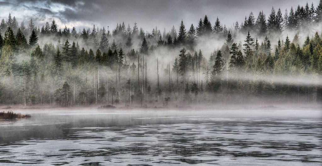
Upper Kanaka Falls
British Columbia • 25 m
By Armen Suny · Last verified Jun 2026
Difficulty
Moderate
Trail Length
5.0 km
Trail Type
Out And Back
Elevation Gain
235 m
About Upper Kanaka Falls
Upper Kanaka Falls is a small, forested cascade on Kanaka Creek in the Metro Vancouver / Fraser Valley area. It sits in a wooded canyon and is typically accessed from the Kanaka Creek regional/conservation trail network. Flow is highest in spring and after heavy rain; in late summer the falls can be reduced to a trickle. Exact published height is not well documented.
The Setting
Upper Kanaka Falls sits at 553 metres in the hills of British Columbia. The falls drop 25 metres.
Why This Waterfall Exists
Upper Kanaka Falls flows over hard intrusive rock laid down about 145-175 million years ago. These resistant rocks form a durable ledge that water cannot easily wear away, creating a 82-foot drop where softer material downstream has already eroded.
Nearby Falls Worth Visiting
Rolley Falls (22 m) lies 5.3 kilometres to the east. Also nearby: Rockwell Falls (12 m, 5.3 km) and Whispering Falls (10 m, 3.7 km).
Trail & Hike Details
The Approach
The moderate 5.0-km out-and-back trail gains 235 metres of elevation on the way to the falls.
Trail Description
From a main Kanaka Creek trailhead follow the signed/established Kanaka Creek trail upstream. Trails are a mix of compacted earth, roots and rocks and may narrow in places; there are informal side spurs and short scrambles to reach viewpoints of the upper falls. The route to the immediate falls viewpoint is typically a short out-and-back from the primary trail, but the last approach can include uneven, potentially slippery ground and limited built infrastructure (stairs/railings).
What to Expect
The falls cascade 25 metres over hard intrusive rock.
Accessibility
The trail is not wheelchair accessible. Uneven terrain and elevation changes require steady footing.
Frequently Asked Questions
🐶 Are Dogs Allowed at Upper Kanaka Falls?
❌ Dogs are not allowed
Are There Any Fees or Permits Required?
🆖 No fees required
🏊 Is There Swimming at Upper Kanaka Falls?
❌ Swimming is not allowed
When to Visit
Spring (snowmelt and seasonal rains) for best water flow and vibrant creek conditions. Late spring to early summer often combines good flow with milder trail conditions. Late summer can have reduced flow but warmer weather.
Seasonal Access
The best time to visit is Spring, Summer, and Fall. Winter access may be limited. Check with the managing park or local authority for current conditions.
Safety Information
Hazards include slippery rocks, wet and muddy trails, steep or unstable creek banks, and rapidly changing water levels after rain. Cell reception can be unreliable in wooded canyon sections. Keep a safe distance from edges, do not climb on wet rocks near the falls, and supervise children closely. Check recent trail reports for conditions (washouts, trail damage) before visiting.
Current Water Conditions
0.2 m³/s
Current discharge — how much water is flowing
Lower than usual for this time of year
Based on 64 years of record
0.84 m
Water depth at gauge
7-Day Discharge Trend
What does this mean for your visit?
Flow is lower than usual for this time of year.
About This Gauge
This gauge is on a nearby waterway and may not reflect exact conditions at the falls.
7-Day Flow Outlook
Based on the WSC gauge KANAKA CREEK NEAR WEBSTER CORNERS (8 km away).
Today
Low
0.2 m³/s
5/10Tomorrow
Low
0.2 m³/s
5/10Tue
Low
0.2 m³/s
5/10Wed
Low
0.1 m³/s
5/10Thu
Moderate
0.2 m³/s
5/10Fri
Moderate
0.1 m³/s
6/10Sat
Moderate
0.1 m³/s
5/10Best window: Fri — moderate flow, cloudy (trip score 6/10).
Best time of year: this gauge typically runs highest from early November to late December, peaking in December.
How we calculate this
This is a transparent outlook, not a precise forecast. We take the waterfall's current flow strength (how it ranks against its historical normal for today, from the nearest WSC stream gauge), carry that ranking forward along the gauge's seasonal curve, and nudge it for forecast rain. Confidence is highest for the next day or two and falls further out. Always check official conditions and your own judgment before visiting — high flows can be dangerous.
Know when to go.
Get a free email alert when waterfalls near Abbotsford hit peak flow. We only send when conditions are worth the trip — no weekly newsletters, no spam.
Weather Forecast
Location & Access
Getting There
Coordinates: 49.2496, -122.447. The falls are reached via the Kanaka Creek trail system (Kanaka Creek Regional/Conservation Park area). Use the park trailheads and follow trails upstream along Kanaka Creek toward the upper reaches. The falls are best located with a GPS or detailed trail map, signage on some informal spur trails can be limited.
Get Directions on Google MapsParking
Parking is generally at nearby park/trailhead lots or roadside parking near the Kanaka Creek park accesses. Parking may be limited on weekends; check posted signs and local park information for restrictions. There may be no formal paid parking at smaller trailheads.
Elevation
553 metres above sea level
Coordinates
49.249643° N, -122.446972° W
Visitor Tips & Gear
• Wear sturdy footwear with good traction, rocks and roots can be slippery. • Use a map or GPS coordinates; informal spur paths can be confusing. • Stay back from creek edges and unstable banks; wet rocks are hazardous. • Check local park pages or recent trip reports for trail conditions and closures before visiting. • Bring insect repellent in spring/summer and rain gear in wet seasons. • Respect posted rules regarding dogs, fires and trail use.
As an Amazon Associate, we earn from qualifying purchases.
With 5.0 km and 235 m of elevation gain, sturdy boots and trekking poles will help on this moderate trail. Sun exposure on the trail makes good sun protection a must in summer.

Columbia Watertight II Rain Jacket
Packs into its own pocket, seam-sealed, and keeps you dry from spray and surprise rain.

Earth Pak Waterproof Dry Bag
Keeps your phone and gear dry when waterfall mist soaks everything else.

Waterproof Phone Pouch (AiRunTech)
Cheap insurance — take photos right next to the falls without killing your phone.

Timberland Euro Sprint Mid Waterproof
Trusted waterproof boot with premium leather and grippy rubber sole — reliable on rocky, wet trails.

TrailBuddy Trekking Poles
Lightweight aluminum, cork grips, and flip-locks that actually hold — a best-seller for good reason.

Sawyer Squeeze Water Filter
The backcountry standard — filters 99.9% of bacteria and weighs just 3 oz.
Where to Stay
Browse vacation cabins and private rentals nearby
Unique outdoor stays — tents, yurts, and treehouses
Rent a campervan or RV for your waterfall road trip
Some links are affiliate links. We may earn a commission at no extra cost to you.
Nearby Campground
Rolley Lake Campground
4.8 km away
Nearby Hot Springs
Hot springs near Abbotsford, British Columbia
Dorr Fumarole Field
Dorr Fumarole Field reaches 194 degrees at 8,168 feet elevation on Mount Baker's active volcanic slopes, producing superheated ...

Sherman Crater Fumaroles
Sherman Crater Fumaroles register 266 degrees Fahrenheit at 9,463 feet elevation within the active volcanic crater atop Mount B...
Baker Hot Spring
Baker Hot Spring emerges at 108 degrees Fahrenheit on US Forest Service land in Mt. Baker National Forest, flowing 59.5 degrees...
Looking for a soak after your hike? Explore more hot springs near Abbotsford, British Columbia on SoakingSprings.
Explore British Columbia springsAdditional Information
Nearby Attractions
Kanaka Creek regional/conservation trails, local parklands in the Maple Ridge / Abbotsford area, scenic stretches of Kanaka Creek. Nearby towns include Maple Ridge, Abbotsford and Mission; larger provincial parks (e.g., Golden Ears) are farther afield.
Wildlife
Typical lowland Pacific Northwest species: deer, a variety of songbirds, small mammals; black bears and coyotes may occur in the region. Kanaka Creek supports fish runs in parts of the watershed; salmon runs may be present in appropriate season in lower reaches. Always give wildlife space and follow local guidance.
Cities near Upper Kanaka Falls
Nearby Waterfalls
Writing about Upper Kanaka Falls? Embed this waterfall on your site for free.