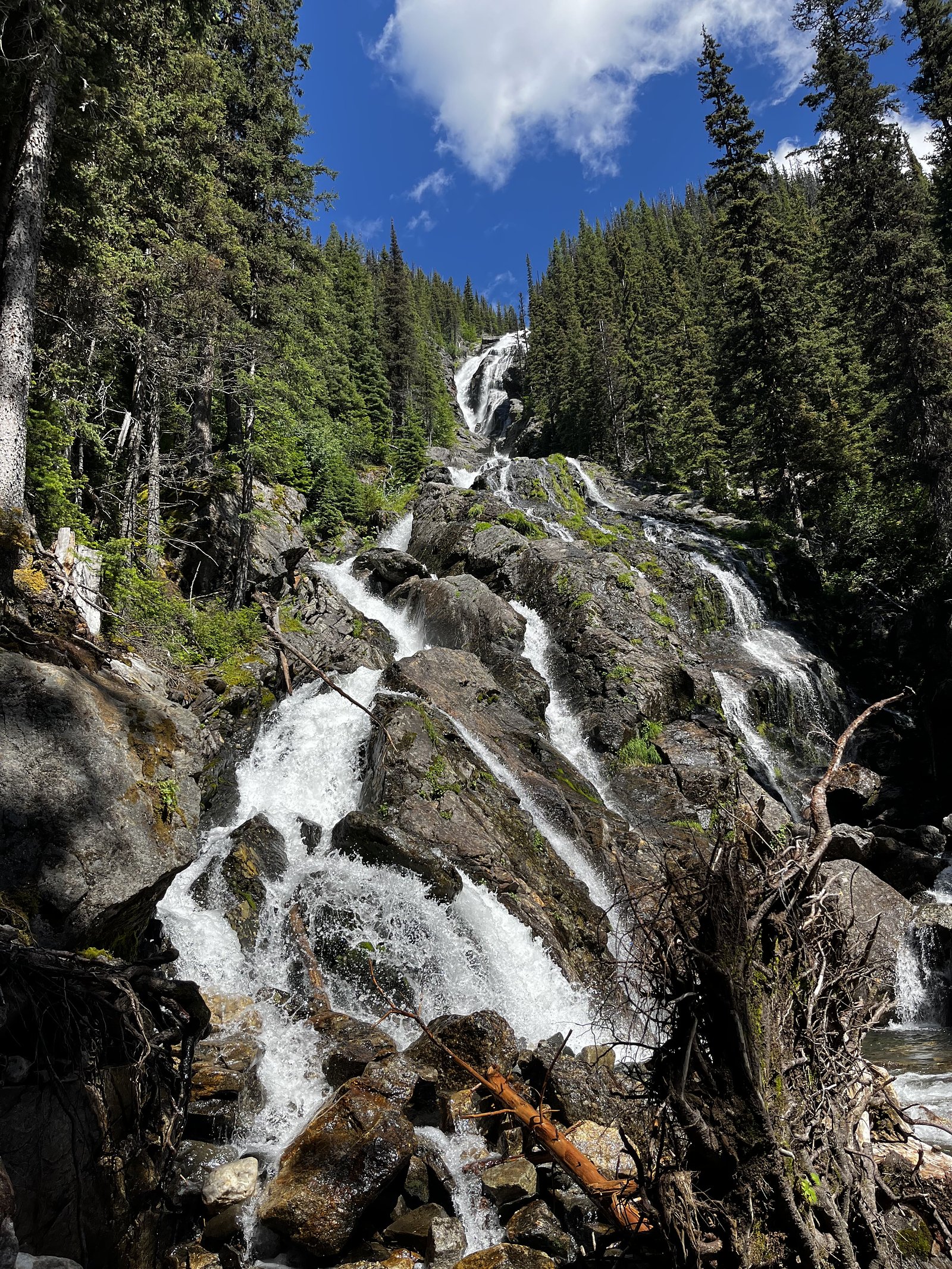
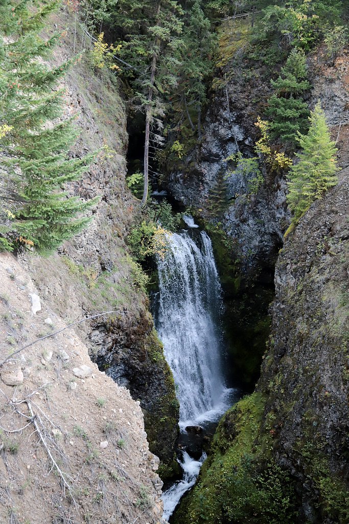
Silvertip Falls
British Columbia • Wells Gray Park • 168 m
By Armen Suny · Last verified Jun 2026
Photo Credits (3)
Difficulty
Moderate
Trail Length
2.3 km
Trail Type
Out And Back
Elevation Gain
152 m
About Silvertip Falls
Silvertip Falls is a waterfall in the central interior of British Columbia at approximately 51.7615, -119.9199. Reliable, detailed public information about the site is limited. The falls appear to be on a smaller tributary and are likely seasonal, highest flows are typically during spring snowmelt and early summer. Access appears to be via forest/secondary roads and may require walking off-trail in rugged terrain. Visitors should treat location details as approximate and confirm current access with local land managers before visiting.
The Setting
Silvertip Falls sits at 1,567 metres within Wells Gray Park, in the high mountains of British Columbia. At 168 metres, it is among the taller waterfalls in British Columbia.
Height: 550 feet
Nearby Falls Worth Visiting
Spahats Falls (60 m) lies 7.1 kilometres to the west. Also nearby: Second Canyon Falls (15 m, 6.4 km) and Allison Falls (15 m, 12.1 km).
Trail & Hike Details
The Approach
The moderate 2.3-km out-and-back trail gains 152 metres of elevation on the way to the falls.
Trail Description
There is no well-documented, maintained trail information available from major public trail resources for Silvertip Falls at these coordinates. Reaching the falls may require route-finding across uneven ground, creek crossings, or a short off-trail bushwhack from a forest service road. Expect natural, unmaintained terrain, roots, loose rock, and steep approaches are possible. If you require a maintained trail or clear signage, consider an alternative, better-documented waterfall or trail nearby.
What to Expect
The falls plunge a dramatic 168 metres.
Accessibility
The trail is not wheelchair accessible. Uneven terrain and elevation changes require steady footing.
Frequently Asked Questions
🐶 Are Dogs Allowed at Silvertip Falls?
❌ Dogs are not allowed
Are There Any Fees or Permits Required?
🆖 No fees required
🏊 Is There Swimming at Silvertip Falls?
❌ Swimming is not allowed
When to Visit
Spring (snowmelt) for highest flows and dramatic water volume; late spring to early summer often balances good flow with more accessible roads. Summer can be drier and easier for road access but flow may be reduced. Fall can offer quieter access and color; winter access may be difficult or dangerous due to snow/ice.
Seasonal Access
The best time to visit is Spring, Summer, and Fall. Access roads and trails may close during winter due to snow. Check with Wells Gray Park for current conditions.
Safety Information
Potential hazards include steep and slippery rocks near the falls, fast or cold water, sudden changes in flow, unstable banks, and limited cell service. Road conditions on forest service roads can change quickly (mud, washouts, gates, active logging). Seasonal hazards include high spring flows and winter ice. Let someone know your route and expected return time. Check with local authorities for any recent access advisories, fire bans, or closures.
Current Water Conditions
382.0 m³/s
Current discharge — how much water is flowing
About average for this time of year
Based on 87 years of record
3.70 m
Water depth at gauge
7-Day Discharge Trend
What does this mean for your visit?
Flow is about average for this time of year.
About This Gauge
This gauge is on a nearby waterway and may not reflect exact conditions at the falls.
7-Day Flow Outlook
Based on the WSC gauge CLEARWATER RIVER NEAR CLEARWATER STATION (15 km away).
Today
Moderate
407 m³/s
5/10Tomorrow
Moderate
420 m³/s
5/10Tue
Moderate
418 m³/s
5/10Wed
Moderate
374 m³/s
6/10Thu
Moderate
347 m³/s
6/10Fri
Moderate
366 m³/s
5/10Sat
Moderate
366 m³/s
5/10Best window: Wed — moderate flow, cloudy (trip score 6/10).
Best time of year: this gauge typically runs highest from early May to early August, peaking in June.
How we calculate this
This is a transparent outlook, not a precise forecast. We take the waterfall's current flow strength (how it ranks against its historical normal for today, from the nearest WSC stream gauge), carry that ranking forward along the gauge's seasonal curve, and nudge it for forecast rain. Confidence is highest for the next day or two and falls further out. Always check official conditions and your own judgment before visiting — high flows can be dangerous.
Weather Forecast
Location & Access
Getting There
The falls are located in a rural interior-BC setting. Access is likely by gravel/forest service roads off the nearest paved highway and then by a short hike or cross-country approach. A high-clearance or 4x4 vehicle may be required on remote logging roads; check local maps and current road conditions. Confirm land status (Crown land, provincial park, or private) before entering.
Get Directions on Google MapsParking
There is no confirmed formal parking lot. Expect primitive pullouts or roadside parking on a forest service road; parking may be limited and informal. Do not block gates, driveways or logging operations.
Elevation
1,567 metres above sea level
Coordinates
51.761479° N, -119.919943° W
Land Management
Managed by Government of British Columbia
Visitor Tips & Gear
1) Check current road and access conditions with the local forest district or ranger office before you go. 2) Use a reliable map/GPS and download offline maps, coordinates are approximate. 3) Wear sturdy footwear and be prepared for wet, slippery rocks. 4) Bring insect repellent in summer. 5) Leave no trace: pack out all garbage. 6) Avoid approaching the edge of cliffs or plunge pools and keep a safe distance from fast-moving water. 7) If unsure about land ownership, seek permission before crossing private property.
As an Amazon Associate, we earn from qualifying purchases.
With 2.3 km and 152 m of elevation gain, sturdy boots and trekking poles will help on this moderate trail. Sun exposure on the trail makes good sun protection a must in summer.

Polarized Sunglasses (Knockaround)
Cuts glare off the water so you actually see the falls — and your photos turn out better too.

Columbia Watertight II Rain Jacket
Packs into its own pocket, seam-sealed, and keeps you dry from spray and surprise rain.

Earth Pak Waterproof Dry Bag
Keeps your phone and gear dry when waterfall mist soaks everything else.

Waterproof Phone Pouch (AiRunTech)
Cheap insurance — take photos right next to the falls without killing your phone.

Timberland Euro Sprint Mid Waterproof
Trusted waterproof boot with premium leather and grippy rubber sole — reliable on rocky, wet trails.

TrailBuddy Trekking Poles
Lightweight aluminum, cork grips, and flip-locks that actually hold — a best-seller for good reason.
Where to Stay
Browse vacation cabins and private rentals nearby
Unique outdoor stays — tents, yurts, and treehouses
Rent a campervan or RV for your waterfall road trip
Some links are affiliate links. We may earn a commission at no extra cost to you.
Nearby Campground
Sheila Lake Wilderness Campsite
3.2 km away
Additional Information
Nearby Attractions
Specific nearby attractions are not confirmed for this exact coordinate. The area is in BC's interior where provincial parks, hiking opportunities, and forestry recreation areas are commonly found, check regional tourism resources or the provincial parks map for nearby points of interest.
Wildlife
Typical interior-BC wildlife may be present: black bear, deer, moose, small mammals, and birds. Be bear aware: make noise while hiking, store food securely, and carry bear spray where appropriate.
Nearby Waterfalls
Writing about Silvertip Falls? Embed this waterfall on your site for free.