Photo Credits (5)
About Randy Falls
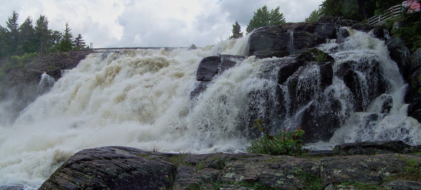
Randy Falls is a small, locally visited cascade in the Parry Sound / Orillia region of central Ontario (coords: 45.2284, -79.4397). Reports from local visitors indicate it is a modest waterfall set on a wooded stream and is most impressive during spring runoff. Precise management (municipal park, Crown land, or privately held) is unclear from widely available sources, so visitors should confirm land access before visiting. Facilities are minimal or non-existent and the site is typically visited for short walks, photography and seasonal viewing rather than formal recreation.
Why This Waterfall Exists
Randy Falls flows over hard metamorphic rock, primarily migmatite and gneiss, laid down over 1.0-1.6 billion years ago. These resistant rocks form a durable ledge that water cannot easily wear away, creating the falls where softer material downstream has already eroded.
Trail & Hike Details
Trail Description
Trail details are not consistently documented online. Visitor accounts for similar small, local waterfalls in this region typically describe a short, informal footpath through mixed hardwood forest down to the stream. The path may be narrow, unmaintained, and can include roots, loose rocks and muddy sections. There are likely no formal boardwalks, stairs or handrails.
What to Expect
Expect a small natural cascade; flow varies seasonally (highest in spring, lower in late summer and early fall). The immediate area is wooded with uneven, potentially slippery rock near the water. There may be limited or no cell service depending on carriers. No formal restroom, picnic or waste facilities, pack out what you bring in. Wildlife in the region can include deer, beaver, various bird species, and occasionally black bears; ticks and black flies are common in warm months.
Accessibility
Access is likely not wheelchair accessible. Trails are probably narrow, uneven and possibly muddy or steep in places with no formalized infrastructure.
Frequently Asked Questions
🐶 Are Dogs Allowed at Randy Falls?
❌ Dogs are not allowed
Are There Any Fees or Permits Required?
🆖 No fees required
🏊 Is There Swimming at Randy Falls?
❌ Swimming is not allowed
When to Visit
Late spring (after snowmelt and during spring runoff) typically provides the most dramatic water flow. Early morning and weekdays reduce crowding. Fall colors can enhance the setting but flows may be lower. Winter may offer frozen scenery but access can be hazardous and roads or trails may be closed or icy.
Seasonal Access
The best time to visit is Spring, Summer, Fall, and Winter. Check with the managing park or local authority for current conditions.
Safety Information
• Slippery rocks and steep banks present fall hazards, stay a safe distance from edges. • Water levels can rise quickly during storms or spring melt, avoid standing on exposed rocks in the channel. • No lifeguards, no safety equipment; swimming or wading carries real risk. • Limited services and possibly limited cell coverage; tell someone your plan and expected return time. • Watch for ticks, and use insect repellent; check for ticks after visiting. • If land is privately owned, obtain permission before entering; be respectful of gates and posted signs.
Current Water Conditions
9.8 m³/s
Current discharge — how much water is flowing
About average for this time of year
Based on 109 years of record
0.85 m
Water depth at gauge
7-Day Discharge Trend
What does this mean for your visit?
Flow is about average for this time of year.
About This Gauge
This gauge is on a nearby waterway and may not reflect exact conditions at the falls.
7-Day Flow Outlook
Based on the WSC gauge NORTH BRANCH MUSKOKA RIVER AT PORT SYDNEY (13 km away).
Today
Moderate
9.9 m³/s
8/10Tomorrow
Moderate
8.8 m³/s
8/10Tue
Moderate
10 m³/s
6/10Wed
Moderate
9.5 m³/s
8/10Thu
Moderate
9.0 m³/s
8/10Fri
Moderate
9.3 m³/s
6/10Sat
Moderate
9.7 m³/s
8/10Best window: Today — moderate flow, partly cloudy (trip score 8/10).
Best time of year: this gauge typically runs highest from mid March to late May, peaking in April.
How we calculate this
This is a transparent outlook, not a precise forecast. We take the waterfall's current flow strength (how it ranks against its historical normal for today, from the nearest WSC stream gauge), carry that ranking forward along the gauge's seasonal curve, and nudge it for forecast rain. Confidence is highest for the next day or two and falls further out. Always check official conditions and your own judgment before visiting — high flows can be dangerous.
Know when to go.
Get a free email alert when waterfalls near Parry Sound hit peak flow. We only send when conditions are worth the trip — no weekly newsletters, no spam.
Weather Forecast
Location & Access
Getting There
Use the supplied coordinates (45.2284, -79.4397) in a GPS device. The falls sit in the broader Parry Sound / Orillia region; approach is likely by local paved or gravel roads with a short unmarked spur or footpath to the water. Exact official access points and signage may be limited or undocumented, confirm local maps or municipal resources before you go.
Get Directions on Google MapsParking
Parking is likely informal (small pullout or roadside parking). There may be no maintained parking lot, signage or amenities. Expect limited capacity and possibly uneven ground; do not block driveways or gates. If in doubt, park well off the roadway and leave room for other vehicles and emergency access.
Elevation
325 metres above sea level
Coordinates
45.228434° N, -79.439743° W
Visitor Tips & Gear
• Confirm land ownership and access before visiting; some small falls in the area are on private land. • Wear sturdy, closed-toe footwear with good traction; rocks and trails can be slippery. • Bring insect repellent in spring and summer and check for ticks after your visit. • Park off the roadway safely and avoid blocking narrow roads. • Respect fragile riverbanks and avoid making new trails, use existing footpaths. • Keep dogs under control and pick up waste; leash rules may apply or landowner permission may be required. • If planning photography near the water, exercise caution on wet rocks, no guardrails or lifeguards are expected.
Where to Stay
Browse vacation cabins and private rentals nearby
Unique outdoor stays — tents, yurts, and treehouses
Rent a campervan or RV for your waterfall road trip
Some links are affiliate links. We may earn a commission at no extra cost to you.
Nearby Campground
Camp Kwasind
3.4 km away
Additional Information
Nearby Attractions
General attractions in the broader region include Georgian Bay, the town of Parry Sound (regional services and boat access), provincial parks along Georgian Bay shoreline and local trails. Exact nearby named attractions relative to Randy Falls should be confirmed with local maps.
Wildlife
Typical central Ontario species: white-tailed deer, beaver, otter, raccoon, red fox, various songbirds and waterfowl. Black bears and moose are possible in the broader region. Ticks (Lyme disease risk) and biting insects are seasonally common.
Cities near Randy Falls
Nearby Waterfalls


Writing about Randy Falls? Embed this waterfall on your site for free.