Photo Credits (5)
About Bemrose Falls
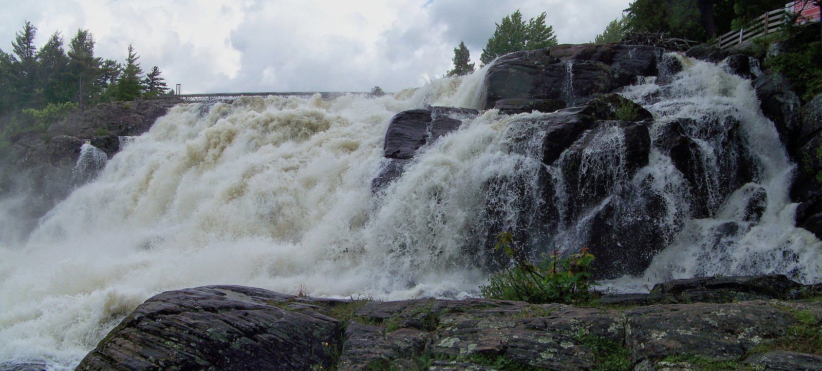
Bemrose Falls is a small, forested waterfall site in central Ontario near the Georgian Bay / Muskoka transitional area. It lies roughly 30–32 miles from the towns of Parry Sound and Orillia (coordinates: 45.2308, -79.4359). The falls appear to be on a small river or creek and are set in mixed hardwood-conifer forest; seasonal flow can vary widely with highest flows in spring. Specific published measurements and official site infrastructure are not confidently documented here, so visitors should expect a relatively natural, minimally developed setting and verify local access before visiting.
Why This Waterfall Exists
Bemrose Falls flows over hard metamorphic rock, primarily migmatite and gneiss, laid down over 1.0-1.6 billion years ago. These resistant rocks form a durable ledge that water cannot easily wear away, creating the falls where softer material downstream has already eroded.
Trail & Hike Details
Trail Description
Detailed, reliable trail descriptions are not available for Bemrose Falls in the sources checked. The site is likely visited via a short walk from a nearby parking/pullout through natural, possibly uneven forest terrain. Trails (if marked) may be primitive and include roots, rocks and modest slopes. There may be little or no official signage, boardwalks, or maintained viewpoints. Hikers should be prepared for an unmaintained path and use good footwear and navigation aids.
What to Expect
Expect a natural, small- to medium-sized waterfall on a creek with seasonal variability, high flow in spring, lower flows in late summer and freeze/ice features in winter. Surroundings are mixed forest with typical Ontario understory. Facilities (toilets, trash receptacles, marked viewpoints) are likely limited or absent. Cell service may be spotty. Rocks near the water will be slippery; approach the water cautiously and avoid climbing on wet rock faces.
Accessibility
The site is likely not wheelchair accessible. Expect uneven, natural terrain and minimal or no constructed viewpoints or boardwalks. Visitors with limited mobility may find access difficult or impossible.
Frequently Asked Questions
🐶 Are Dogs Allowed at Bemrose Falls?
❌ Dogs are not allowed
Are There Any Fees or Permits Required?
🆖 No fees required
🏊 Is There Swimming at Bemrose Falls?
❌ Swimming is not allowed
When to Visit
Spring for highest flows and dynamic water; fall for foliage color and photography; summer for warmer conditions but potentially lower flows and more insects. Winter can offer ice and snow scenery but is hazardous (ice, icy approaches) and may limit safe viewing.
Seasonal Access
The best time to visit is Spring, Summer, Fall, and Winter. Check with the managing park or local authority for current conditions.
Safety Information
Primary hazards include slippery and unstable rocks near the water, fast currents during high-flow seasons (spring), cold water temperatures, unstable banks, and limited emergency access/cell service in some areas. In winter, ice and snow can conceal hazards and make routes treacherous. Carry a charged phone, tell someone your plan, wear appropriate footwear, and avoid getting too close to edges. If wildlife is present, follow recommended wildlife-safety practices.
Current Water Conditions
9.9 m³/s
Current discharge — how much water is flowing
About average for this time of year
Based on 109 years of record
0.86 m
Water depth at gauge
7-Day Discharge Trend
What does this mean for your visit?
Flow is about average for this time of year.
About This Gauge
This gauge is on a nearby waterway and may not reflect exact conditions at the falls.
7-Day Flow Outlook
Based on the WSC gauge NORTH BRANCH MUSKOKA RIVER AT PORT SYDNEY (13 km away).
Today
Moderate
9.9 m³/s
8/10Tomorrow
Moderate
9.5 m³/s
6/10Tue
Strong
10 m³/s
7/10Wed
Moderate
10 m³/s
6/10Thu
Moderate
9.4 m³/s
8/10Fri
Moderate
8.6 m³/s
8/10Sat
Moderate
9.4 m³/s
9/10Best window: Sat — moderate flow, mainly sunny (trip score 9/10).
Best time of year: this gauge typically runs highest from mid March to late May, peaking in April.
How we calculate this
This is a transparent outlook, not a precise forecast. We take the waterfall's current flow strength (how it ranks against its historical normal for today, from the nearest WSC stream gauge), carry that ranking forward along the gauge's seasonal curve, and nudge it for forecast rain. Confidence is highest for the next day or two and falls further out. Always check official conditions and your own judgment before visiting — high flows can be dangerous.
Know when to go.
Get a free email alert when waterfalls near Parry Sound hit peak flow. We only send when conditions are worth the trip — no weekly newsletters, no spam.
Weather Forecast
Location & Access
Getting There
Use the provided coordinates (45.2308, -79.4359) in a GPS device or mapping app. The waterfall is in a rural/woodland area between Parry Sound (~30.3 miles) and Orillia (~31.6 miles). Access likely requires driving on secondary roads off the nearest provincial highways; some last-mile access may be on narrow or unpaved roads. Confirm local road conditions and any private property boundaries before attempting to visit.
Get Directions on Google MapsParking
Parking information is not well documented. Expect limited or informal parking (roadside pullouts or a small unmarked lot). Do not block driveways or gates. If there is a formal parking area it may be small and seasonal.
Elevation
310 metres above sea level
Coordinates
45.230780° N, -79.435854° W
Visitor Tips & Gear
1) Confirm private property boundaries and obtain permission if access crosses private land. 2) Use a detailed map or GPS coordinates, signage may be limited. 3) Wear sturdy footwear with good traction; bring insect repellent and layers for changing weather. 4) If visiting in spring, expect higher and faster flows and stay back from powerful currents and undercut banks. 5) Leave no trace: pack out all trash. 6) Check local park, municipal, or conservation authority resources for the latest access advisories before travel.
Where to Stay
Browse vacation cabins and private rentals nearby
Unique outdoor stays — tents, yurts, and treehouses
Rent a campervan or RV for your waterfall road trip
Some links are affiliate links. We may earn a commission at no extra cost to you.
Nearby Campground
Camp Kwasind
3.7 km away
Additional Information
Nearby Attractions
General regional attractions include Georgian Bay shoreline areas and provincial parks within the Parry Sound / Muskoka region; specific nearby parks or official attractions are not confirmed for this exact waterfall location, check regional tourism or provincial park listings for up-to-date options.
Wildlife
Typical central Ontario forest wildlife: white-tailed deer, small mammals, a variety of songbirds, grouse, and potentially black bears. Also expect ticks and biting insects in warmer months. Exercise standard wildlife precautions (store food securely, be aware of bears, check for ticks).
Cities near Bemrose Falls
Nearby Waterfalls


Writing about Bemrose Falls? Embed this waterfall on your site for free.