Nairn Falls
British Columbia • 40 m
By Armen Suny · Last verified Jun 2026
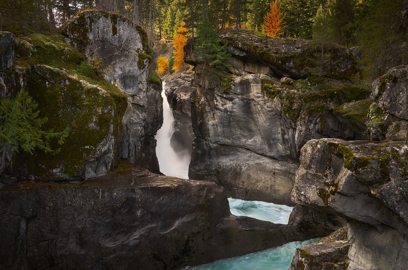
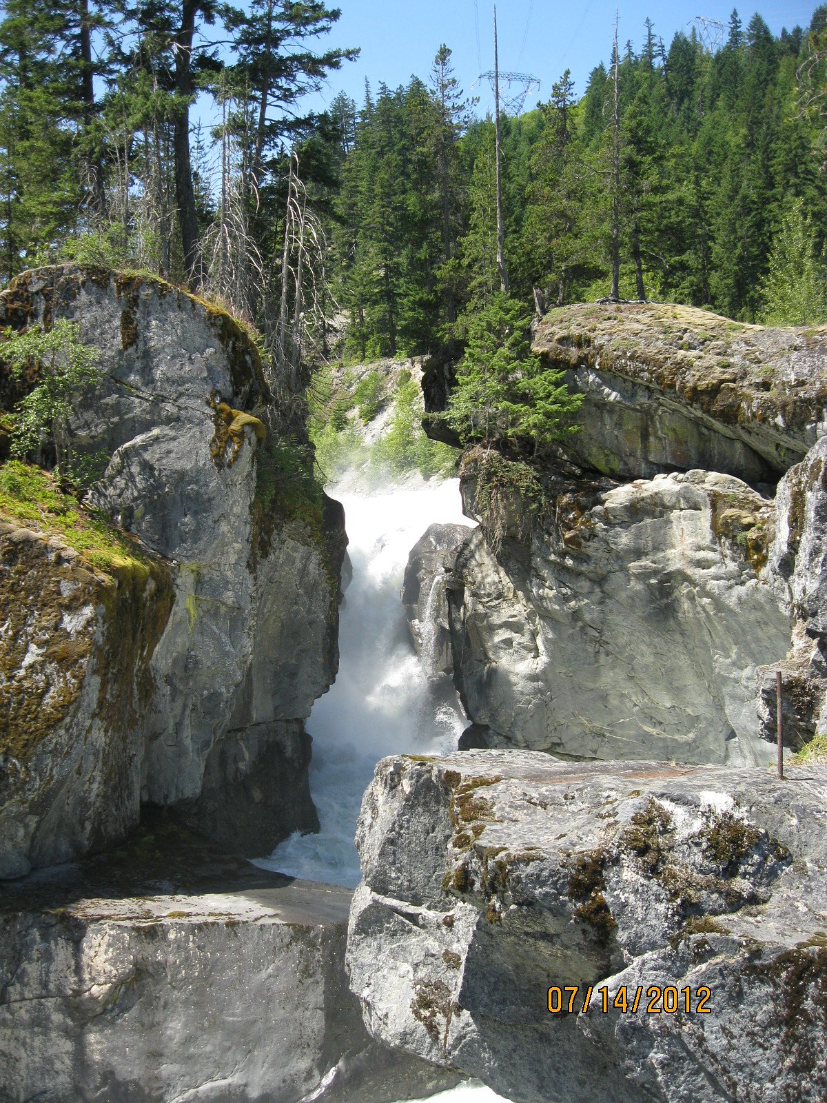
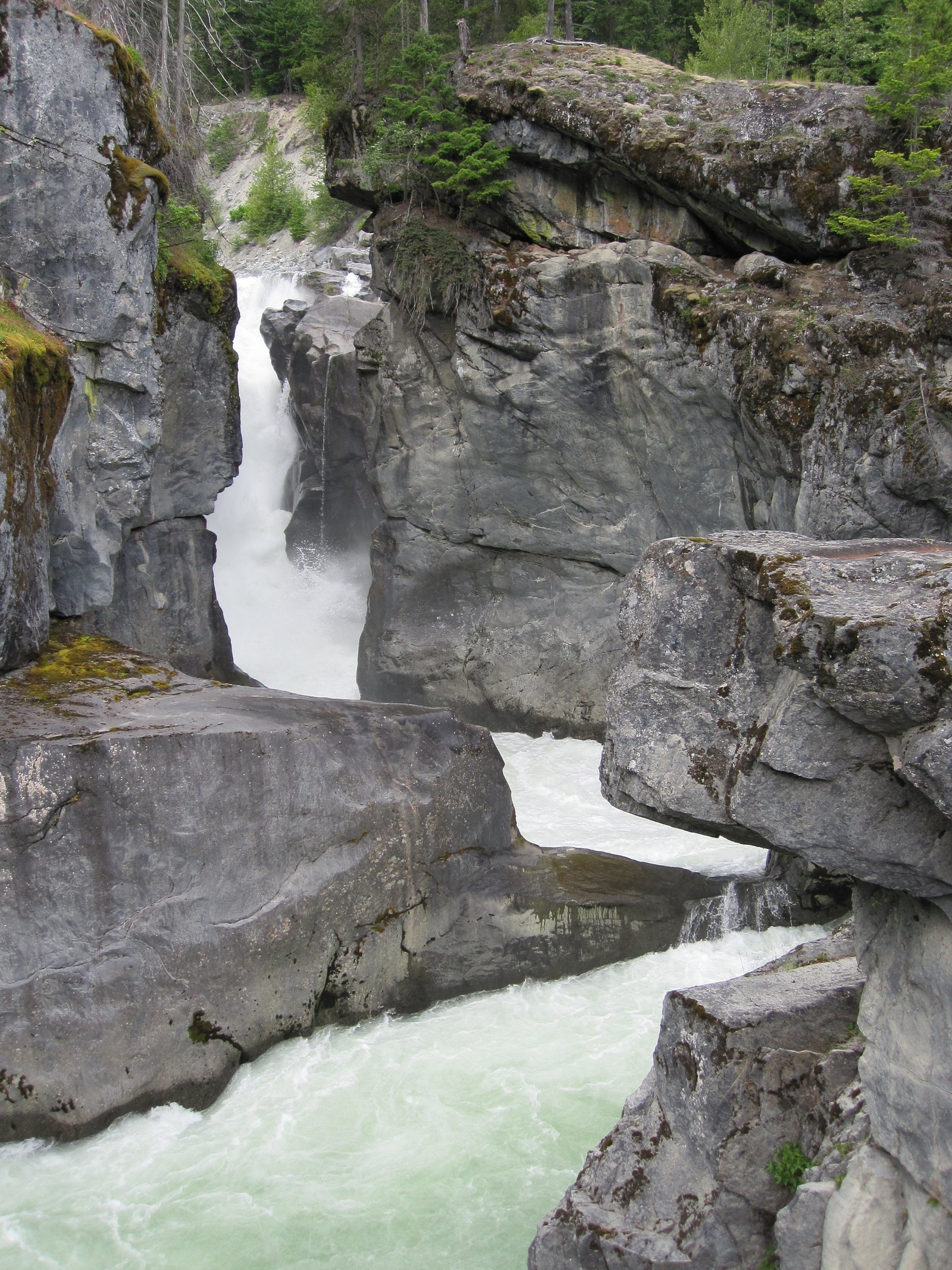
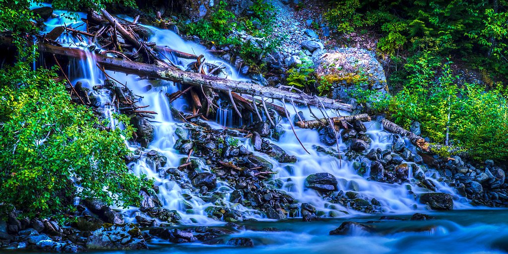
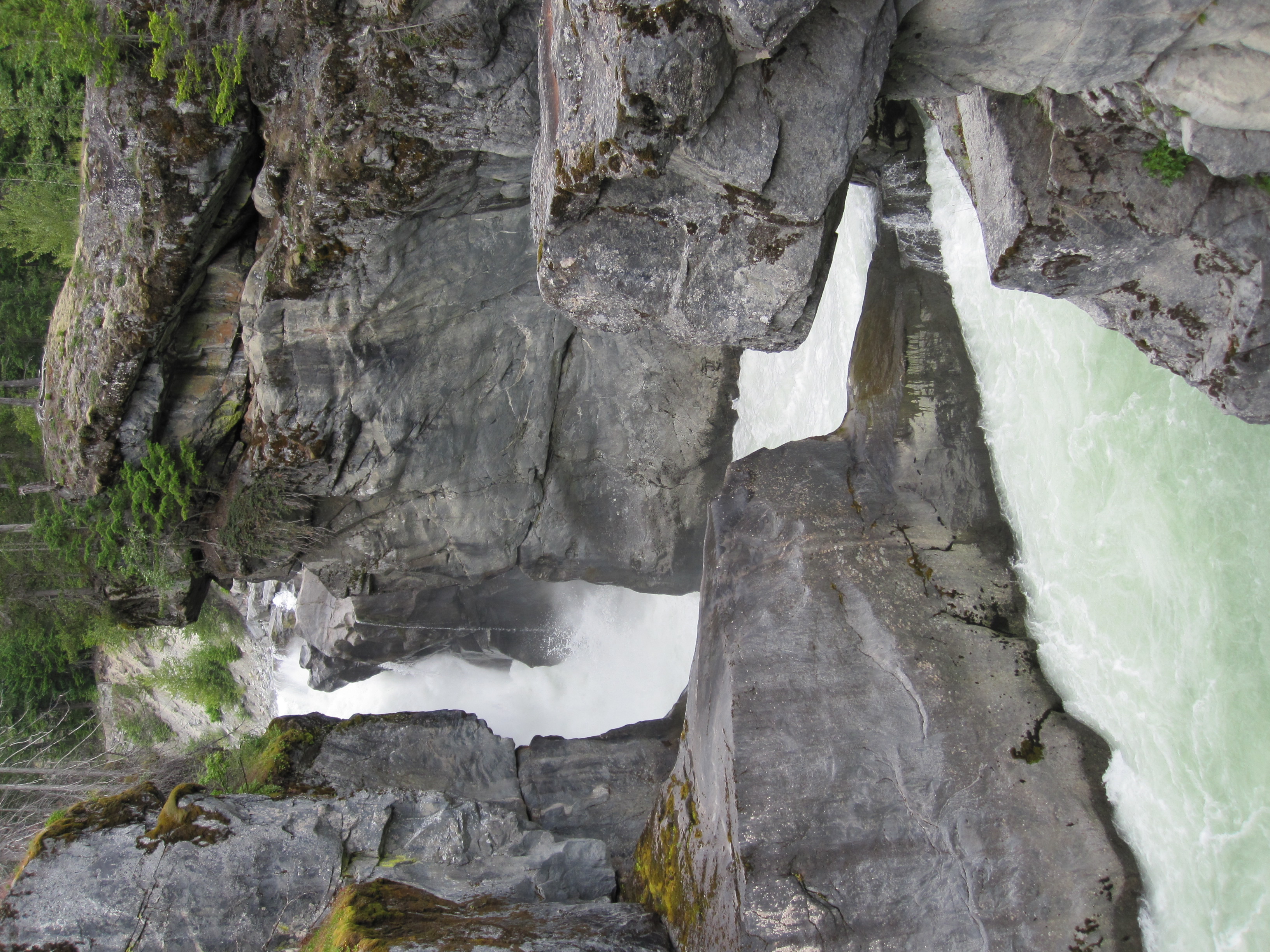
Photo Credits (5)
Difficulty
Easy
Trail Length
1.0 km
Trail Type
Out And Back
About Nairn Falls
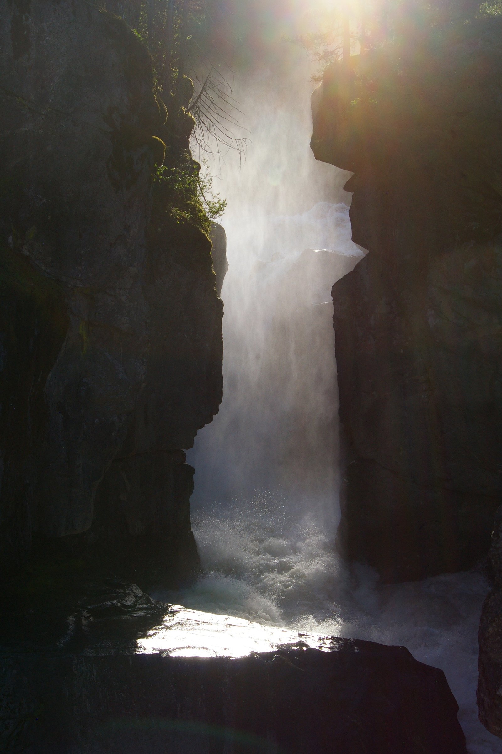
Nairn Falls is a waterfall on the Green River located in Nairn Falls Provincial Park in southwestern British Columbia. The falls are known for a powerful, narrow chute and dramatic rocky gorge; they are commonly visited from a short, well-marked trail and viewing area accessed from Highway 99 (Sea-to-Sky Highway). The site is popular for short walks and photography; flows are highest in spring and early summer during snowmelt. Exact vertical height figures vary in sources and are not confirmed here.
The Setting
Nairn Falls sits at 289 metres within NAIRN FALLS PARK, in the foothills of British Columbia. At 40 metres, it is among the taller waterfalls in British Columbia.
Why This Waterfall Exists
Nairn Falls flows over hard intrusive rock laid down about 66-145 million years ago. These resistant rocks form a durable ledge that water cannot easily wear away, creating a 131-foot drop where softer material downstream has already eroded.
Nearby Falls Worth Visiting
Mystery Falls (100 m) lies 8.0 kilometres to the south. Also nearby: Pemberton Creek Falls (15 m, 3.5 km).
Trail & Hike Details
Trail Description
The main trail is a short, well-marked out-and-back route that leads from the parking/day-use area through forest to a series of viewpoints above and beside the gorge. Expect boardwalks, stairs and short sections of uneven, rocky trail near the river. The primary viewpoints give clear views of the falls and the turbulent river below; some informal routes lead closer to the water but can be steep and slippery.
What to Expect
The falls cascade 40 metres over hard intrusive rock.
Accessibility
The trail is short and relatively flat, but the surface may be uneven. Contact the managing agency for accessibility details.
Frequently Asked Questions
🐶 Are Dogs Allowed at Nairn Falls?
❌ Dogs are not allowed
Are There Any Fees or Permits Required?
🆖 No fees required
🏊 Is There Swimming at Nairn Falls?
❌ Swimming is not allowed
When to Visit
Spring and early summer for highest flows and dramatic water volume; early morning or late afternoon for softer light and fewer visitors. Fall offers color in surrounding forest. Winter can provide ice/hoarfrost scenery but trails may be icy and access more hazardous.
Seasonal Access
The best time to visit is Spring, Summer, Fall, and Winter. Check with the managing park or local authority for current conditions.
Safety Information
Main hazards include slippery rocks and boardwalks (especially when wet or icy), steep drop-offs at the gorge, and powerful, cold river currents. Stay on marked trails and behind barriers. Exercise caution in winter (ice) and during high-water periods. Bring a charged phone, tell someone your plans, and be prepared for rapidly changing weather. If visiting in bear country, follow local wildlife-safety guidance.
Current Water Conditions
2.6 m³/s
Current discharge — how much water is flowing
About average for this time of year
Based on 37 years of record
2.08 m
Water depth at gauge
7-Day Discharge Trend
What does this mean for your visit?
Flow is about average for this time of year.
About This Gauge
7-Day Flow Outlook
Based on the WSC gauge PEMBERTON CREEK NEAR PEMBERTON (4 km away).
Today
Moderate
2.6 m³/s
6/10Tomorrow
Moderate
2.5 m³/s
6/10Thu
Moderate
2.4 m³/s
6/10Fri
Moderate
2.5 m³/s
6/10Sat
Moderate
2.4 m³/s
6/10Sun
Moderate
2.6 m³/s
5/10Mon
Moderate
2.7 m³/s
6/10Best window: Today — moderate flow, cloudy (trip score 6/10).
Best time of year: this gauge typically runs highest from mid May to early August, peaking in June.
How we calculate this
This is a transparent outlook, not a precise forecast. We take the waterfall's current flow strength (how it ranks against its historical normal for today, from the nearest WSC stream gauge), carry that ranking forward along the gauge's seasonal curve, and nudge it for forecast rain. Confidence is highest for the next day or two and falls further out. Always check official conditions and your own judgment before visiting — high flows can be dangerous.
Know when to go.
Get a free email alert when waterfalls near Lillooet hit peak flow. We only send when conditions are worth the trip — no weekly newsletters, no spam.
Weather Forecast
Location & Access
Getting There
From BC Highway 99 (Sea-to-Sky Highway) follow signs for Nairn Falls Provincial Park. There is a small day-use area and parking lot directly adjacent to the highway; the main trailhead to the viewpoints starts from that lot. The coordinates provided (50.2888, -122.8327) point to the general park area. The site is in the Sea-to-Sky corridor; it is roughly within the broader region north of Squamish and near Pemberton (user-provided distance to Lillooet: ~57.3 miles).
Get Directions on Google MapsParking
There is a small paved parking lot/day-use area beside Highway 99. Parking can fill on busy summer weekends; park in designated spaces only. Larger vehicles or trailers may have limited space.
Elevation
289 metres above sea level
Coordinates
50.288810° N, -122.832691° W
Land Management
Managed by Government of British Columbia
Visitor Tips & Gear
Arrive early on summer weekends to secure parking. Stay behind railings and on established trails, the gorge has steep edges and strong currents. Wear sturdy shoes; expect mud after rain. In winter and shoulder seasons bring traction (microspikes) because boardwalks and stairs can ice over. Keep dogs on leash and pack out all waste. Check BC Parks or local reports for any temporary closures or trail advisories before visiting.
Where to Stay
Browse vacation cabins and private rentals nearby
Unique outdoor stays — tents, yurts, and treehouses
Rent a campervan or RV for your waterfall road trip
Some links are affiliate links. We may earn a commission at no extra cost to you.
Nearby Campground
Nairn Falls Campground
1.3 km away
Additional Information
Nearby Attractions
Sea-to-Sky corridor destinations (Whistler, Squamish) and the Pemberton area are nearby along Highway 99. Local rivers, trails and provincial parks in the region offer additional hiking and fishing opportunities. Check a regional map for up-to-date listings and distances.
Wildlife
Typical coastal-mountain wildlife may be present: black bears, deer, small mammals, raptors and waterfowl. Salmon runs may occur in nearby rivers depending on season. Observe wildlife from a distance and secure food; carry bear spray where appropriate.
Cities near Nairn Falls
Nearby Waterfalls
Writing about Nairn Falls? Embed this waterfall on your site for free.