Lower Ziggurat Fall
By Armen Suny · Last verified Jun 2026
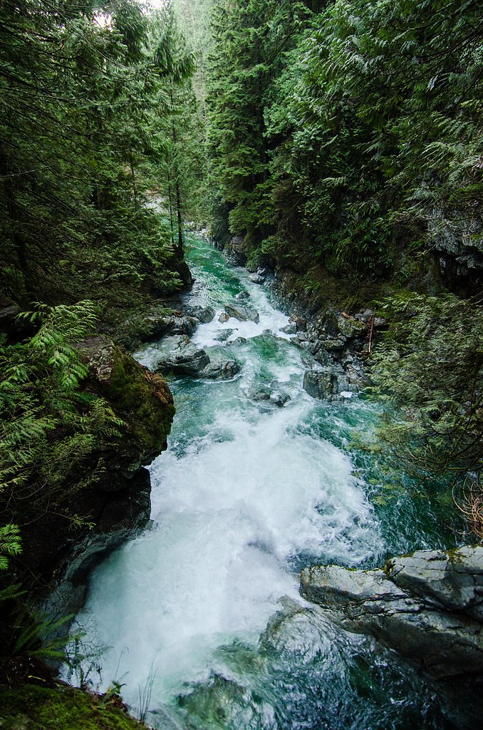
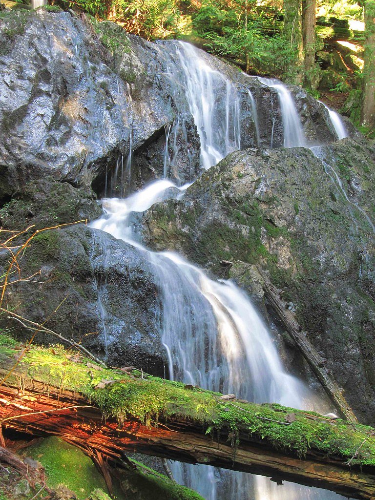
About Lower Ziggurat Fall
Lower Ziggurat Fall is a relatively obscure cascade in interior British Columbia located near coordinates 50.1904, -122.8605. The feature appears to be a natural cascade or series of drops on a tributary in a remote, mountainous setting. Detailed, published information (height, official name usage, or management jurisdiction) is limited; descriptions below are conservative and based on typical conditions for similar remote BC cascades.
Why This Waterfall Exists
Lower Ziggurat Fall flows over hard intrusive rock laid down about 66-145 million years ago. These resistant rocks form a durable ledge that water cannot easily wear away, creating the falls where softer material downstream has already eroded.
Nearby Falls Worth Visiting
Mystery Falls (100 m) lies 3.4 kilometres to the northeast.
Trail & Hike Details
Trail Description
There are no widely published, maintained trail descriptions for Lower Ziggurat Fall. Access is likely via an unmarked spur, scramble over uneven terrain, or a short bushwhack from a nearby road or creek crossing. Expect limited or no signage, steep banks near the stream, and potentially thick underbrush in places. Trail conditions will vary seasonally and may be impacted by logging activity or washouts.
What to Expect
Expect a remote, natural waterfall setting with limited facilities (no restrooms, signage, or established viewpoints). Water flow may be strongly seasonal, highest during spring snowmelt and after heavy rain, lower in late summer. Terrain near the falls may include slippery rocks, loose scree, and steep drop-offs. Cell coverage may be intermittent or absent.
Accessibility
Likely not wheelchair accessible. Approaches are expected to be over rough, uneven ground with potential scrambling; not suitable for strollers. Accessibility details are not documented.
Frequently Asked Questions
🐶 Are Dogs Allowed at Lower Ziggurat Fall?
❌ Dogs are not allowed
Are There Any Fees or Permits Required?
🆖 No fees required
🏊 Is There Swimming at Lower Ziggurat Fall?
❌ Swimming is not allowed
When to Visit
Late spring to early summer for peak flows and scenic volume from snowmelt. Mid-to-late summer may offer easier road access and drier approaches but lower water levels. Fall can be attractive for color and cooler conditions. Winter access may be difficult or hazardous due to snow and ice.
Seasonal Access
The best time to visit is Spring, Summer, and Fall. Winter access may be limited. Check with the managing park or local authority for current conditions.
Safety Information
Hazards include: slippery rocks and cliff edges, fast or cold water currents, sudden changes in water flow (especially during rain or spring melt), unstable or loose footing, poor or no cell reception, and potential wildlife encounters. Roads to the site may be rough, narrow, and subject to washouts or seasonal closures. Use caution, avoid risky cliff-edge viewing, and do not climb wet rock faces. Carry appropriate safety and navigation gear and check local conditions before traveling.
Current Water Conditions
5.1 m³/s
Current discharge — how much water is flowing
Much lower than usual for this time of year
Based on 29 years of record
5.95 m
Water depth at gauge
7-Day Discharge Trend
What does this mean for your visit?
Flow is well below normal for this time of year, so the waterfall may be a trickle.
About This Gauge
This gauge is on a nearby waterway and may not reflect exact conditions at the falls.
7-Day Flow Outlook
Based on the WSC gauge FITZSIMMONS CREEK BELOW BLACKCOMB CREEK (10 km away).
Today
Barely Flowing
5.1 m³/s
4/10Tomorrow
Barely Flowing
5.1 m³/s
4/10Tue
Barely Flowing
5.2 m³/s
4/10Wed
Barely Flowing
5.0 m³/s
4/10Thu
Barely Flowing
5.1 m³/s
4/10Fri
Barely Flowing
5.1 m³/s
3/10Sat
Low
5.5 m³/s
4/10Best window: Today — barely flowing flow, cloudy (trip score 4/10).
Best time of year: this gauge typically runs highest from late May to mid August, peaking in June.
How we calculate this
This is a transparent outlook, not a precise forecast. We take the waterfall's current flow strength (how it ranks against its historical normal for today, from the nearest WSC stream gauge), carry that ranking forward along the gauge's seasonal curve, and nudge it for forecast rain. Confidence is highest for the next day or two and falls further out. Always check official conditions and your own judgment before visiting — high flows can be dangerous.
Know when to go.
Get a free email alert when waterfalls near Lillooet hit peak flow. We only send when conditions are worth the trip — no weekly newsletters, no spam.
Weather Forecast
Location & Access
Getting There
The waterfall is in a remote area of British Columbia. The nearest notable town referenced is Lillooet (approximately 63.3 miles by the straight-line distance provided). Access will likely require travel on secondary or forestry/logging roads; a high-clearance vehicle (4x4 recommended) may be needed. Visitors should use the provided coordinates (50.1904, -122.8605) with an up-to-date topographic map or GPS device and check regional forest service maps and local signage before travel. Land ownership in the area may include Crown land, forest tenure areas, or private parcels, confirm access with local authorities when possible.
Get Directions on Google MapsParking
There is likely no formal parking lot. Expect informal roadside pullouts or minimal space to park off a logging/forest road. Do not block gates or access roads. If access requires crossing private property, parking may be restricted, confirm permissions in advance.
Elevation
778 metres above sea level
Coordinates
50.190355° N, -122.860472° W
Visitor Tips & Gear
1) Use the exact coordinates and a topographic map/GPS. 2) Bring a high-clearance vehicle and be prepared for rough forest roads; check road closures and conditions first. 3) Wear sturdy, waterproof footwear and be prepared for a short scramble. 4) Respect private property and posted signs; obtain permission if required. 5) Tell someone your route and expected return time; cell reception may be poor. 6) Avoid cliff edges and wet rocks; conditions can be more hazardous after rain or during high flows.
Where to Stay
Browse vacation cabins and private rentals nearby
Unique outdoor stays — tents, yurts, and treehouses
Rent a campervan or RV for your waterfall road trip
Some links are affiliate links. We may earn a commission at no extra cost to you.
Nearby Campground
Riverside Dispersed Camping
2.8 km away
Additional Information
Nearby Attractions
The broader region includes typical interior-BC scenery, mountain views, rivers and lakes, and other informal waterfalls. The nearest named town referenced is Lillooet (user-provided distance ~63.3 miles); consult local visitor information for established attractions and services.
Wildlife
Typical interior British Columbia wildlife may be present: black bears, cougars (rare), deer, small mammals, and a variety of birds (including raptors). Practice standard wildlife awareness and food storage precautions.
Cities near Lower Ziggurat Fall
Nearby Waterfalls
Writing about Lower Ziggurat Fall? Embed this waterfall on your site for free.