Upper Ziggurat Falls
By Armen Suny · Last verified Jun 2026
Difficulty
Hard
About Upper Ziggurat Falls
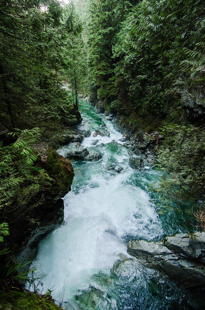
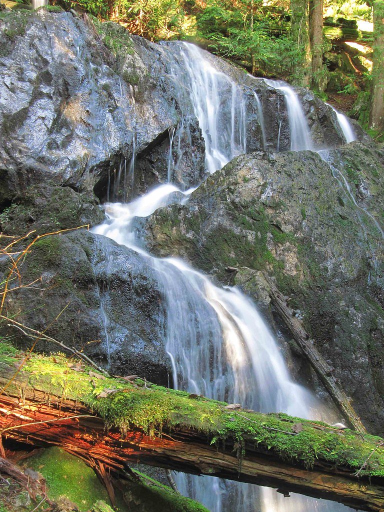
Upper Ziggurat Falls is a little-documented waterfall located in interior British Columbia at approximately 50.19, -122.8561, about 63.1 miles from Lillooet. Reports and mapping data indicate a remote, rugged site likely reached by forest roads and/or cross-country travel rather than a maintained, signed trail. Visitor information is sparse; the waterfall is best known to local hikers and backcountry users rather than as a developed attraction.
Why This Waterfall Exists
Upper Ziggurat Falls flows over hard intrusive rock laid down about 66-145 million years ago. These resistant rocks form a durable ledge that water cannot easily wear away, creating the falls where softer material downstream has already eroded.
Nearby Falls Worth Visiting
Mystery Falls (100 m) lies 3.4 kilometres to the northeast.
Trail & Hike Details
Trail Description
There is no well-documented maintained trail to Upper Ziggurat Falls in mainstream trail databases. Reaching the falls likely involves driving on secondary/forestry roads followed by an unmarked hike with route-finding, bushwhacking, and possible steep or unstable sections near the creek. Expect minimal trail infrastructure (no boardwalks, railings, or official footbridges). Because published trail length and elevation gain are not available, be prepared for a variable and potentially strenuous approach.
What to Expect
A remote, natural waterfall setting with low visitor numbers. Flow is likely highest in spring/early summer from snowmelt and after heavy rain; late summer flows may be reduced. Terrain can be steep and rocky near the falls with slippery surfaces and loose talus. Limited or no cell coverage in some areas. Wildlife such as black bears, deer, and other interior-BC species may be present.
Accessibility
The trail involves steep, uneven terrain with significant elevation change and is not accessible to mobility devices.
Frequently Asked Questions
🐶 Are Dogs Allowed at Upper Ziggurat Falls?
❌ Dogs are not allowed
Are There Any Fees or Permits Required?
🆖 No fees required
🏊 Is There Swimming at Upper Ziggurat Falls?
❌ Swimming is not allowed
When to Visit
Spring to early summer for highest flows (snowmelt). Late summer and early fall may offer lower flows but easier road access in dry years. Winter access can be hazardous or impossible due to snow and ice; roads may be closed or impassable.
Seasonal Access
The best time to visit is Spring, Summer, and Fall. Winter access may be limited. Check with the managing park or local authority for current conditions.
Safety Information
This is a remote and potentially hazardous location. Hazards may include: steep and slippery rock, loose talus, sudden changes in water flow (especially after rain or spring melt), limited cell coverage, challenging road conditions, and wildlife encounters. Use caution near cliff edges and wet rock, avoid cliff-edge photography stunts, and never underestimate water current or undertow. Travel with partners where possible and carry emergency communication. Check local forestry/park/municipal sources for road closures, and consider a conservative turnaround time to avoid returning in the dark.
Current Water Conditions
5.1 m³/s
Current discharge — how much water is flowing
Much lower than usual for this time of year
Based on 29 years of record
5.95 m
Water depth at gauge
7-Day Discharge Trend
What does this mean for your visit?
Flow is well below normal for this time of year, so the waterfall may be a trickle.
About This Gauge
This gauge is on a nearby waterway and may not reflect exact conditions at the falls.
7-Day Flow Outlook
Based on the WSC gauge FITZSIMMONS CREEK BELOW BLACKCOMB CREEK (10 km away).
Today
Barely Flowing
5.1 m³/s
4/10Tomorrow
Barely Flowing
5.1 m³/s
4/10Tue
Barely Flowing
5.2 m³/s
4/10Wed
Barely Flowing
5.0 m³/s
4/10Thu
Barely Flowing
5.1 m³/s
4/10Fri
Barely Flowing
5.1 m³/s
3/10Sat
Low
5.5 m³/s
4/10Best window: Today — barely flowing flow, cloudy (trip score 4/10).
Best time of year: this gauge typically runs highest from late May to mid August, peaking in June.
How we calculate this
This is a transparent outlook, not a precise forecast. We take the waterfall's current flow strength (how it ranks against its historical normal for today, from the nearest WSC stream gauge), carry that ranking forward along the gauge's seasonal curve, and nudge it for forecast rain. Confidence is highest for the next day or two and falls further out. Always check official conditions and your own judgment before visiting — high flows can be dangerous.
Know when to go.
Get a free email alert when waterfalls near Lillooet hit peak flow. We only send when conditions are worth the trip — no weekly newsletters, no spam.
Weather Forecast
Location & Access
Getting There
The falls are located roughly 63 miles (by straight-line distance) from Lillooet. Exact route information is limited; access likely requires driving on secondary/forest/seasonal roads and then hiking or bushwhacking. Use the provided coordinates (50.19, -122.8561) in a reliable mapping/GPS device. Expect limited signage and potentially rough/unmaintained roads, 4WD may be necessary. Check current conditions with local authorities (BC Parks, regional district, or local forestry office) before travel.
Get Directions on Google MapsParking
No formal developed parking lot is documented. Parking is likely informal at the end of a forest/seasonal road or at a pullout; parking may be limited and subject to season/road condition. Park responsibly off the travel lane and avoid blocking gates or private access.
Elevation
962 metres above sea level
Coordinates
50.190020° N, -122.856083° W
Visitor Tips & Gear
1) Use the provided coordinates in a reliable GPS and bring a topographic map and compass; do not rely solely on cellphone navigation. 2) Check current road and weather conditions with local authorities before heading out. 3) Expect rough forest roads, consider a high-clearance 4WD vehicle. 4) Wear sturdy footwear with good traction; bring trekking poles for steep or unstable ground. 5) Pack for self-sufficiency (water, food, first-aid, emergency shelter). 6) Leave no trace: pack out all waste and avoid disturbing vegetation or stream banks. 7) Tell someone your route and expected return time.
Where to Stay
Browse vacation cabins and private rentals nearby
Unique outdoor stays — tents, yurts, and treehouses
Rent a campervan or RV for your waterfall road trip
Some links are affiliate links. We may earn a commission at no extra cost to you.
Nearby Campground
Riverside Dispersed Camping
3 km away
Additional Information
Nearby Attractions
Nearest notable community: Lillooet (approx. 63 miles). Other regional features may include Fraser River corridors, set of backcountry lakes and creeks common to the interior of BC. Exact nearby named attractions are not well-documented for this specific waterfall.
Wildlife
Interior-BC wildlife such as black bears, deer, small mammals, raptors, and possibly cougar or moose may be present. Practice wildlife safety: store food securely and carry bear spray where appropriate.
Cities near Upper Ziggurat Falls
Nearby Waterfalls
Writing about Upper Ziggurat Falls? Embed this waterfall on your site for free.