Helen Falls
Ontario • Lady Evelyn-Smoothwater Provincial Park • 25 m
By Armen Suny · Last verified Jun 2026
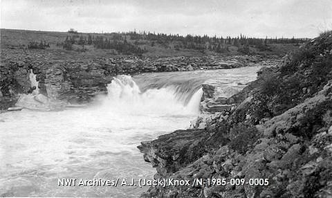
Photo Credits (2)
Difficulty
Hard
About Helen Falls
Helen Falls is a waterfall on the Lady Evelyn River within Lady Evelyn-Smoothwater Provincial Park in Northeastern Ontario, Canada. The falls are the highest and most impressive on the Lady Evelyn River with a height more than 25 m (82 ft).
The Setting
Helen Falls sits at 337 metres within Lady Evelyn-Smoothwater Provincial Park, in the foothills of Ontario. The falls drop 25 metres.
Why This Waterfall Exists
Helen Falls flows over Cobalt Group, a soft fine-grained rock layer deposited over 2.3-2.5 billion years ago. These soft rocks erode readily, allowing the stream to carve a 82-foot drop into the landscape.
Nearby Falls Worth Visiting
Centre Falls (17 m) lies 1.0 kilometres to the east. Also nearby: Cabin Falls (9 m, 1.4 km).
Trail & Hike Details
Trail Description
There is no widely maintained, official trail to Helen Falls. Approaches reported by backcountry hikers and paddlers vary and may include portages, rough bushwhacking, river travel, and unmaintained logging-road sections. Trails (if present) are likely uneven, rocky and may cross wet/muddy areas. Expect route-finding and map/GPS navigation skills to be required.
What to Expect
The falls cascade 25 metres over soft fine-grained rock.
Accessibility
The trail involves steep, uneven terrain with significant elevation change and is not accessible to mobility devices.
Frequently Asked Questions
🐶 Are Dogs Allowed at Helen Falls?
❌ Dogs are not allowed
Are There Any Fees or Permits Required?
🆖 No fees required
🏊 Is There Swimming at Helen Falls?
❌ Swimming is not allowed
When to Visit
Late spring for highest water flow and dramatic cascades; early fall for stable weather and fall colours. Summer offers warmer paddling conditions but more insects. Winter visits are possible but involve ice hazards and difficult travel, only for experienced winter backcountry users.
Seasonal Access
The best time to visit is Spring, Summer, and Fall. Winter access may be limited. Check with Lady Evelyn-Smoothwater Provincial Park for current conditions.
Safety Information
Hazards include slippery rocks and steep drops near the falls, strong currents and undertows in plunge pools, cold water temperatures, limited cell coverage, rough/seasonal roads, and wildlife encounters. In spring, high flows increase hazards. Winter ice can be unstable. Carry appropriate safety gear, avoid getting too close to edges, and treat the area as backcountry, be self-sufficient.
Current Water Conditions
Based on a Water Survey of Canada gauge 37 km away
5.8 m³/s
Current discharge — how much water is flowing
About average for this time of year
Based on 39 years of record
4.57 m
Water depth at gauge
7-Day Discharge Trend
What does this mean for your visit?
Flow is about average for this time of year.
About This Gauge
This gauge is on a regional waterway. Conditions at the falls may differ, especially after local rain.
7-Day Flow Outlook
Based on the WSC gauge STURGEON RIVER AT UPPER GOOSE FALLS (37 km away).
Today
Moderate
5.7 m³/s
6/10Tomorrow
Moderate
6.0 m³/s
5/10Tue
Moderate
6.2 m³/s
5/10Wed
Moderate
5.5 m³/s
6/10Thu
Moderate
5.5 m³/s
5/10Fri
Moderate
5.4 m³/s
5/10Sat
Moderate
5.1 m³/s
6/10Best window: Today — moderate flow, cloudy (trip score 6/10).
Best time of year: this gauge typically runs highest from early April to mid June, peaking in May.
How we calculate this
This is a transparent outlook, not a precise forecast. We take the waterfall's current flow strength (how it ranks against its historical normal for today, from the nearest WSC stream gauge), carry that ranking forward along the gauge's seasonal curve, and nudge it for forecast rain. Confidence is highest for the next day or two and falls further out. Always check official conditions and your own judgment before visiting — high flows can be dangerous.
Know when to go.
Get a free email alert when waterfalls near Cobalt hit peak flow. We only send when conditions are worth the trip — no weekly newsletters, no spam.
Weather Forecast
Location & Access
Getting There
The falls lie in a remote area of northeastern Ontario approximately 32 miles from Cobalt and 38.4 miles from New Liskeard (Temiskaming Shores). Access commonly requires travel on secondary/logging roads and backcountry trails or approach by canoe/kayak on connected rivers and lakes. Roads may be rough and seasonally gated; cell service is often unreliable. Confirm current conditions with Ontario Parks, local outfitters, or map resources before travel.
Get Directions on Google MapsParking
There is no widely advertised formal parking lot. Small pullouts or informal parking may exist on nearby logging or access roads; park responsibly and avoid blocking gates or private access. If approaching by water, expect to launch from local lakes or river put-ins.
Elevation
337 metres above sea level
Coordinates
47.291910° N, -80.333894° W
Land Management
Managed by Ontario Parks
Visitor Tips & Gear
1) Treat access as a backcountry trip: bring map, compass/GPS, and tell someone your plan. 2) Wear sturdy, waterproof footwear with good grip, rocks near falls are slippery. 3) Carry insect repellent and sun/rain layers. 4) Expect limited or no cell coverage; consider a satellite communicator for remote travel. 5) Respect private property and locked gates on logging roads. 6) Check local sources (Ontario Parks, local outfitters, AllTrails or recent trip reports) for up-to-date access notes.
Where to Stay
Browse vacation cabins and private rentals nearby
Unique outdoor stays — tents, yurts, and treehouses
Rent a campervan or RV for your waterfall road trip
Some links are affiliate links. We may earn a commission at no extra cost to you.
Nearby Campground
Ranger Point
22.2 km away
Additional Information
Nearby Attractions
Towns: Cobalt and New Liskeard (Temiskaming Shores) offer services. Region includes multiple lakes, rivers and provincial backcountry areas; nearby provincial parks and recreational waterways may offer additional paddling and hiking opportunities. Confirm exact nearby park names and access points before travel.
Wildlife
Typical northern Ontario wildlife: black bears, moose, white-tailed deer, beavers, otters, and a variety of birds (raptors, waterfowl). Insect season includes black flies and mosquitoes in spring/early summer.
Cities near Helen Falls
Nearby Waterfalls
Other waterfalls named Helen Falls
1 other waterfall shares this name across Canada.
Writing about Helen Falls? Embed this waterfall on your site for free.