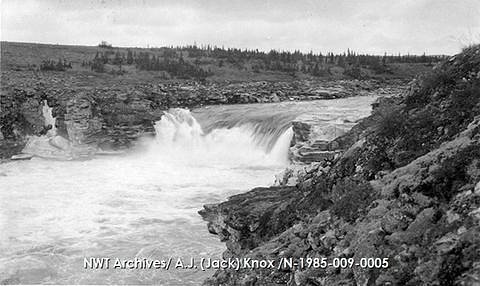
Helen Falls
Northwest Territories • 8 m
By Armen Suny · Last verified Jun 2026

Photo Credits (1)
Difficulty
Hard
About Helen Falls
Helen Falls is a remote waterfall in the Northwest Territories near coordinates 63.6567, -104.7277. It appears to be on a river in a sparsely populated region of the Dehcho or Sahtu area. Public, detailed trail descriptions and official infrastructure information are limited; access is likely remote and may require watercraft, floatplane, or a long backcountry approach. Visitors should treat location details as approximate and confirm access with local authorities or maps before travel.
The Setting
Helen Falls sits at 190 metres within Thelon Wildlife Sanctuary, in the foothills of Northwest Territories. The falls drop 8 metres.
Why This Waterfall Exists
Helen Falls flows over hard dark volcanic rock laid down over 1.6-1.8 billion years ago. These resistant rocks form a durable ledge that water cannot easily wear away, creating a 26-foot drop where softer material downstream has already eroded.
Nearby Falls Worth Visiting
Macdonald Falls (18 m) lies 8.7 kilometres to the north.
Trail & Hike Details
Trail Description
There is no widely published maintained trail to Helen Falls. Approaches are likely cross-country or via river travel. Expect unmarked routes, uneven terrain, and potentially dense vegetation or muskeg. Visitors should be experienced in navigation and backcountry travel or hire local guides. Because official trail data is not available, treat this as a remote backcountry visit rather than a day-hike on a maintained path.
What to Expect
The falls drop 8 metres over fragmental sedimentary rock.
Accessibility
The trail involves steep, uneven terrain with significant elevation change and is not accessible to mobility devices.
Frequently Asked Questions
🐶 Are Dogs Allowed at Helen Falls?
❌ Dogs are not allowed
Are There Any Fees or Permits Required?
🆖 No fees required
🏊 Is There Swimming at Helen Falls?
❌ Swimming is not allowed
When to Visit
Late spring to early summer for higher water flow (after snowmelt). Mid to late summer can be easier for access (less runoff) but may have lower flows and more insects. Winter access (snowmobile or ski) is possible in some areas but can be hazardous and should only be attempted by experienced winter travelers with up-to-date local information.
Seasonal Access
The best time to visit is Spring, Summer, Fall, and Winter. Check with the managing park or local authority for current conditions.
Safety Information
Hazards include: strong river currents and undertows near the falls, slippery and unstable shoreline and rocks, rapidly changing weather, hypothermia risk in cold water, insect-borne discomfort in summer, limited or no cell service, and potential encounters with large wildlife. Travel with communication equipment, tell someone your plan, and be prepared for remote rescue delays. If uncertain about route or conditions, hire a local guide or operator.
Current Water Conditions
31.4 m³/s
Current discharge — how much water is flowing
Much lower than usual for this time of year
Based on 42 years of record
4.91 m
Water depth at gauge
7-Day Discharge Trend
What does this mean for your visit?
Flow is well below normal for this time of year, so the waterfall may be a trickle.
About This Gauge
This gauge is on a nearby waterway and may not reflect exact conditions at the falls.
7-Day Flow Outlook
Based on the WSC gauge HANBURY RIVER ABOVE HOARE LAKE (22 km away).
Today
Barely Flowing
34 m³/s
3/10Tomorrow
Barely Flowing
32 m³/s
4/10Tue
Barely Flowing
32 m³/s
3/10Wed
Low
33 m³/s
4/10Thu
Barely Flowing
31 m³/s
4/10Fri
Barely Flowing
31 m³/s
3/10Sat
Low
31 m³/s
4/10Best window: Tomorrow — barely flowing flow, cloudy (trip score 4/10).
Best time of year: this gauge typically runs highest from early June to early September, peaking in June.
How we calculate this
This is a transparent outlook, not a precise forecast. We take the waterfall's current flow strength (how it ranks against its historical normal for today, from the nearest WSC stream gauge), carry that ranking forward along the gauge's seasonal curve, and nudge it for forecast rain. Confidence is highest for the next day or two and falls further out. Always check official conditions and your own judgment before visiting — high flows can be dangerous.
Weather Forecast
Location & Access
Getting There
The falls are in a remote part of the Northwest Territories. There is likely no paved road access directly to the falls. Typical approaches in this region are by floatplane, boat/canoe/kayak on the river system, or a long cross-country hike. Nearest formal services and maintained roads may be many kilometres away. Confirm access options with local authorities, regional tourist offices, or topographic maps prior to travel.
Get Directions on Google MapsParking
No confirmed parking or established lot at the falls. If visiting by road to a nearby access point, expect primitive or informal parking only; floatplane or boat access may be required.
Elevation
190 metres above sea level
Coordinates
63.656666° N, -104.727680° W
Land Management
Managed by Government of the Northwest Territories
Visitor Tips & Gear
1) Confirm exact coordinates and approach options with local authorities or regional tourist offices before travel. 2) Carry topographic maps, GPS and a personal locator beacon or satellite communicator. 3) Be prepared for river travel (if accessing by boat/canoe) and strong currents near falls. 4) Practice bear-aware behaviour: carry bear spray and know how to store food. 5) Wear sturdy, waterproof boots and dress in layers; conditions can change quickly. 6) Leave no trace: pack out all waste and avoid disturbing fragile shoreline vegetation.
Where to Stay
Browse vacation cabins and private rentals nearby
Unique outdoor stays — tents, yurts, and treehouses
Rent a campervan or RV for your waterfall road trip
Some links are affiliate links. We may earn a commission at no extra cost to you.
Additional Information
Nearby Attractions
Detailed nearby attraction listings are not confirmed. The region contains extensive wilderness, rivers, lakes and opportunities for canoeing, fishing, and backcountry camping; consult regional tourism resources or maps for named lakes, rivers and parks near the coordinates provided.
Wildlife
Typical northern boreal and subarctic wildlife may be present: black and grizzly bear (depending on exact location), moose, wolves, beavers, migratory birds, and abundant insects in summer. Take standard wildlife precautions.
Nearby Waterfalls
Other waterfalls named Helen Falls
1 other waterfall shares this name across Canada.
Writing about Helen Falls? Embed this waterfall on your site for free.