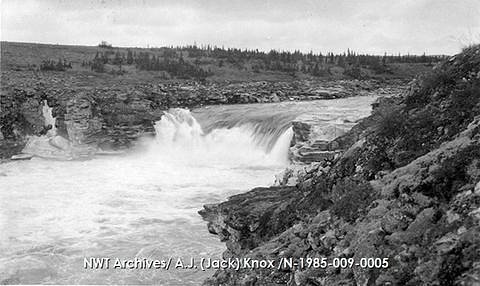
Frank Falls
Ontario • Lady Evelyn-Smoothwater Provincial Park
By Armen Suny · Last verified Jun 2026
About Frank Falls
Frank Falls is a small, likely seasonal waterfall in northeastern Ontario near the communities of Cobalt and New Liskeard. Precise published information on the waterfall is sparse; descriptions from local visitors indicate a modest cascade or drop on a forested stream. Water flow may be highest in spring runoff and after heavy rains and the falls may be partially or fully frozen in winter. Access appears to be via secondary or forest roads with an unmarked or lightly maintained trail to the viewpoint. Visitors should treat specifics such as exact height, formal viewing platforms, and nearby facilities as uncertain.
The Setting
Frank Falls sits at 315 metres within Lady Evelyn-Smoothwater Provincial Park, in the foothills of Ontario.
Why This Waterfall Exists
Frank Falls flows over Cobalt Group, a soft fine-grained rock layer deposited over 2.3-2.5 billion years ago. These soft rocks erode readily, allowing the stream to carve a vertical drop into the landscape.
Nearby Falls Worth Visiting
Helen Falls (25 m) lies 2.7 kilometres to the southwest. Also nearby: Centre Falls (17 m, 1.8 km) and Cabin Falls (9 m, 4.2 km).
Trail & Hike Details
Trail Description
Public accounts suggest the route to Frank Falls is a short, rudimentary path from a roadside pullout or from a logging/forest road. Trails in this region can be unmarked, uneven, and may require scrambling over roots, rocks, or downed trees near the stream. Expect limited or no constructed viewpoints, stairs, or railings. Because reliable trail maps or authoritative guide entries are not available, treat approach and exit as potentially rough and route-finding may be necessary.
What to Expect
A small forested cascade with changing flow depending on season and recent precipitation. Surrounding terrain is typical northern Ontario boreal/mixed forest with mossy rocks, wetlands nearby, and occasional steep or slippery banks near the water. In spring the falls may be at peak flow; in late summer flows can be lower. In winter the falls may be iced over and adjacent rock and trail surfaces will be slippery and potentially hazardous. Cell coverage may be limited in remote sections.
Accessibility
Accessibility is likely limited. The approach is probably on uneven, natural terrain without constructed boardwalks or ramps. Not recommended for wheelchairs or those requiring firm, even surfaces unless confirmed otherwise.
Frequently Asked Questions
🐶 Are Dogs Allowed at Frank Falls?
❌ Dogs are not allowed
Are There Any Fees or Permits Required?
🆖 No fees required
🏊 Is There Swimming at Frank Falls?
❌ Swimming is not allowed
When to Visit
Spring (late snowmelt/after thaw) for highest flows. Early summer for pleasant weather and green surroundings. Fall for autumn colors and lower visitor numbers. Winter can offer scenic ice formations but brings significant hazards (ice, deep snow, limited access) and may require winter travel skills.
Seasonal Access
The best time to visit is Spring, Summer, Fall, and Winter. Check with Lady Evelyn-Smoothwater Provincial Park for current conditions.
Safety Information
Hazards may include slippery and unstable rocks near the falls, steep or collapsing banks, cold and fast water, unpredictable flow after storms, icy surfaces in winter, and limited cell service. Trails and roads may cross active logging areas, be aware of trucks and seasonal closures. Always tell someone your plans, bring emergency supplies, and favor more caution when route information is sparse.
7-Day Flow Outlook
Based on the WSC gauge MONTREAL RIVER AT MOUNTAIN CHUTES (38 km away).
Best time of year: this gauge typically runs highest from mid April to early July, peaking in May.
How we calculate this
This is a transparent outlook, not a precise forecast. We take the waterfall's current flow strength (how it ranks against its historical normal for today, from the nearest WSC stream gauge), carry that ranking forward along the gauge's seasonal curve, and nudge it for forecast rain. Confidence is highest for the next day or two and falls further out. Always check official conditions and your own judgment before visiting — high flows can be dangerous.
Know when to go.
Get a free email alert when waterfalls near Cobalt hit peak flow. We only send when conditions are worth the trip — no weekly newsletters, no spam.
Weather Forecast
Location & Access
Getting There
Coordinates: 47.3061, -80.3037. The falls lie in the Temiskaming/Cobalt area of northeastern Ontario, roughly 30 miles from Cobalt and 36.4 miles from New Liskeard. Expect to reach the area by paved highways followed by secondary/forest/logging roads; some last-mile access may be on gravel or seasonal roads. Exact public access points and trailheads are not well documented and may be unmarked.
Get Directions on Google MapsParking
Likely roadside or informal parking at a trailhead or pullout. No confirmed official parking lot, signage, or facilities, plan for limited or no formal parking and possible shared use of a small turnout. Park clear of gates and driveways and avoid blocking roads.
Elevation
315 metres above sea level
Coordinates
47.306101° N, -80.303690° W
Land Management
Managed by Ontario Parks
Visitor Tips & Gear
• Wear sturdy, waterproof footwear with good traction; expect wet, muddy, and uneven ground. • Treat the route as unmaintained: bring a map, GPS, or download offline maps in advance. • Check recent local reports or contact local tourism offices (Cobalt/Temiskaming area) for up-to-date access information and road conditions. • No guaranteed facilities, bring water, snacks, and a small first-aid kit; pack out all trash. • If visiting winter or shoulder seasons, carry traction devices (microspikes) and be prepared for cold, icy conditions. • Be bear-aware in season: store food properly and make noise while hiking. • Respect private property, some access roads in the region may cross private or active logging lands.
Where to Stay
Browse vacation cabins and private rentals nearby
Unique outdoor stays — tents, yurts, and treehouses
Rent a campervan or RV for your waterfall road trip
Some links are affiliate links. We may earn a commission at no extra cost to you.
Nearby Campground
Ranger Point
23.4 km away
Additional Information
Nearby Attractions
The broader region includes the historic mining sites and museums around Cobalt and recreational lakes and trails in the Temiskaming district. Local towns like Cobalt and New Liskeard (Temiskaming Shores area) have visitor information that can help with up-to-date road and trail conditions.
Wildlife
Typical northern Ontario species: white-tailed deer, moose, black bear, beaver, otter, various waterfowl and songbirds. Also ticks and biting insects in warmer months.
Cities near Frank Falls
Nearby Waterfalls
Writing about Frank Falls? Embed this waterfall on your site for free.