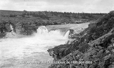
Cabin Falls
Ontario • Lady Evelyn-Smoothwater Provincial Park • 9 m
By Armen Suny · Last verified Jun 2026
Photo Credits (4)
About Cabin Falls
Cabin Falls is a lesser-known waterfall located in northeastern Ontario (coordinates 47.2823, -80.3461), in the general region between Cobalt and New Liskeard. It appears to lie on a small river or stream cutting through Canadian Shield bedrock and mixed boreal forest. Detailed, widely-published trail or management information for this specific falls is limited; access may be via local forestry or secondary roads and an unmarked or lightly used trail or bushwhack. Visitors should plan for a remote, natural setting and expect minimal developed facilities.
The Setting
Cabin Falls sits at 336 metres within Lady Evelyn-Smoothwater Provincial Park, in the foothills of Ontario. The falls drop 9 metres.
Why This Waterfall Exists
Cabin Falls flows over Nipissing Diabase, a hard intrusive rock layer deposited over 2.3-2.5 billion years ago. These resistant rocks form a durable ledge that water cannot easily wear away, creating a 30-foot drop where softer material downstream has already eroded.
Nearby Falls Worth Visiting
Helen Falls (25 m) lies 1.4 kilometres to the northeast. Also nearby: Centre Falls (17 m, 2.4 km).
Trail & Hike Details
Trail Description
There is limited authoritative trail information for Cabin Falls. Expect an unmaintained or lightly maintained approach through boreal forest and exposed rock typical of the Canadian Shield. Trails (if present) may be narrow, uneven, and not waymarked. Reaching viewpoint areas may require short stretches of rock scrambling or stepping on wet, mossy surfaces. If no trail exists, a short bushwhack from a nearby road or logging track may be required.
What to Expect
The falls drop 9 metres over hard intrusive rock.
Accessibility
Likely not accessible for visitors with limited mobility. Expect natural, uneven terrain, rock steps and possible short scrambles; no developed accessible infrastructure is likely.
Frequently Asked Questions
🐶 Are Dogs Allowed at Cabin Falls?
❌ Dogs are not allowed
Are There Any Fees or Permits Required?
🆖 No fees required
🏊 Is There Swimming at Cabin Falls?
❌ Swimming is not allowed
When to Visit
Spring (high water/strong flow) and fall (foliage) are often the most scenic. Summer is convenient for road access but flows can be lower. Winter is possible for viewing frozen cascades but requires winter travel experience and gear. Check road conditions and seasonal closures before visiting.
Seasonal Access
The best time to visit is Spring, Summer, Fall, and Winter. Check with Lady Evelyn-Smoothwater Provincial Park for current conditions.
Safety Information
This is a remote, minimally developed site. Hazards include slippery and unstable rock, steep banks, cold and fast-moving water, variable stream flow, unstable shorelines, ticks and potential bear encounters, and limited or no cell service. Forest/seasonal roads may be impassable after heavy rain, during spring thaw or in winter. Always check local road and weather conditions, carry adequate safety gear, and do not approach the edge of cliffs or fast-moving water. If uncertain about land access, contact local municipal offices or Ontario provincial authorities to confirm permission to enter.
Current Water Conditions
Based on a Water Survey of Canada gauge 35.7 km away
5.8 m³/s
Current discharge — how much water is flowing
About average for this time of year
Based on 39 years of record
4.57 m
Water depth at gauge
7-Day Discharge Trend
What does this mean for your visit?
Flow is about average for this time of year.
About This Gauge
This gauge is on a regional waterway. Conditions at the falls may differ, especially after local rain.
7-Day Flow Outlook
Based on the WSC gauge STURGEON RIVER AT UPPER GOOSE FALLS (36 km away).
Today
Moderate
5.7 m³/s
6/10Tomorrow
Moderate
5.6 m³/s
6/10Tue
Moderate
6.0 m³/s
5/10Wed
Moderate
5.5 m³/s
6/10Thu
Moderate
5.5 m³/s
5/10Fri
Moderate
5.4 m³/s
5/10Sat
Moderate
5.1 m³/s
6/10Best window: Today — moderate flow, fog (trip score 6/10).
Best time of year: this gauge typically runs highest from early April to mid June, peaking in May.
How we calculate this
This is a transparent outlook, not a precise forecast. We take the waterfall's current flow strength (how it ranks against its historical normal for today, from the nearest WSC stream gauge), carry that ranking forward along the gauge's seasonal curve, and nudge it for forecast rain. Confidence is highest for the next day or two and falls further out. Always check official conditions and your own judgment before visiting — high flows can be dangerous.
Know when to go.
Get a free email alert when waterfalls near Cobalt hit peak flow. We only send when conditions are worth the trip — no weekly newsletters, no spam.
Weather Forecast
Location & Access
Getting There
The falls are roughly 33 miles from Cobalt and 39.4 miles from New Liskeard (user-supplied distances). From either town you will likely drive on a combination of paved highways and secondary/unpaved forest or logging roads. Exact public access points and trailheads are not well documented; a GPS device using the provided coordinates is recommended. Expect limited signage and possibly private land or forestry activity nearby, confirm local access before entering.
Get Directions on Google MapsParking
No official parking lot is documented. Parking may be an informal pullout on a secondary road or small parking area near a trailhead if one exists. Park clear of gates, private driveways and avoid blocking forestry equipment access. If unsure, check with local municipal offices or Crown land access information.
Elevation
336 metres above sea level
Coordinates
47.282312° N, -80.346098° W
Land Management
Managed by Ontario Parks
Visitor Tips & Gear
• Use the provided coordinates and carry a GPS or offline map; cell service may be spotty or absent. • Wear sturdy, water-resistant footwear with good traction. • Bring insect repellent in spring/summer and dress in layers for variable weather. • Tell someone your route and expected return time, area can be remote. • Respect private property and forestry operations; check for local access restrictions. • Pack out all trash and follow Leave No Trace principles.
Where to Stay
Browse vacation cabins and private rentals nearby
Unique outdoor stays — tents, yurts, and treehouses
Rent a campervan or RV for your waterfall road trip
Some links are affiliate links. We may earn a commission at no extra cost to you.
Nearby Campground
Ranger Point
21.4 km away
Additional Information
Nearby Attractions
Nearby towns include Cobalt and New Liskeard which provide services. The broader region offers other outdoor opportunities typical of northeastern Ontario: lakes, canoe routes, provincial parks and Crown land backcountry. Specific named attractions near the coordinates are not well documented.
Wildlife
Typical northeastern Ontario fauna: black bear, moose, white-tailed deer, beaver, small mammals, and a variety of birds. Ticks can be present in warmer months. Practice wildlife safety and store food securely.
Cities near Cabin Falls
Nearby Waterfalls
Writing about Cabin Falls? Embed this waterfall on your site for free.