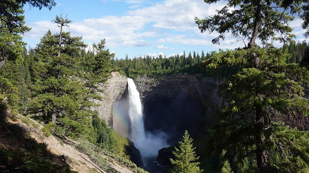
Grotto Falls
By Armen Suny · Last verified Jun 2026
About Grotto Falls
Grotto Falls (coordinates 49.3994, -122.2234) is a forested, grotto-style cascade located in the Fraser Valley / Chilliwack region of British Columbia. The waterfall is set in a mossy, shaded ravine and is likely to have its strongest flow in spring and after heavy rains. Specific published trail and height information for this exact named feature at these coordinates is limited; details below err on the side of caution where sources are uncertain.
Why This Waterfall Exists
Grotto Falls flows over hard intrusive rock laid down about 145-162 million years ago. These resistant rocks form a durable ledge that water cannot easily wear away, creating the falls where softer material downstream has already eroded.
Nearby Falls Worth Visiting
Thunder Falls (100 m) lies 3.7 kilometres to the southwest. Also nearby: Cascade Falls (30 m, 13.8 km) and McDonald Falls (25 m, 11.4 km).
Trail & Hike Details
Trail Description
Trail information for this specific Grotto Falls location is sparse in mainstream trail guides. Expect an unimproved forest path that may include rooty or rocky footing, short steep sections down into the ravine, and possibly a stream or creek crossing. There may be no formal switchbacks, signage, or maintained boardwalks. Trails in this part of the Fraser Valley are often single-track and can be muddy after rain.
What to Expect
A shaded, moss-lined gorge with a small to medium cascade that forms a grotto-like alcove. Flow can be seasonal, highest in spring snowmelt and after rainy periods, lower in late summer during dry spells. Expect slippery rock surfaces near the water, limited viewpoints, and a compact area at the base of the falls. Cell reception may be patchy in forested ravines. Conditions may change rapidly after heavy rain.
Accessibility
The site is likely not wheelchair-accessible. Expect uneven, narrow, and potentially steep terrain; not suitable for strollers. Those with limited mobility should use caution and consider visiting more developed viewpoints in nearby parks.
Frequently Asked Questions
🐶 Are Dogs Allowed at Grotto Falls?
❌ Dogs are not allowed
Are There Any Fees or Permits Required?
🆖 No fees required
🏊 Is There Swimming at Grotto Falls?
❌ Swimming is not allowed
When to Visit
Late spring and early summer for higher water flow and greener moss-covered canyon walls. Early fall offers cooler temperatures and fewer bugs while still retaining scenic color. Winter visits are possible but may involve icy, hazardous conditions, only attempt with proper footwear and experience.
Seasonal Access
The best time to visit is Spring, Summer, Fall, and Winter. Check with the managing park or local authority for current conditions.
Safety Information
Hazards may include slippery rocks, steep drop-offs, fast-moving water after heavy rain, unstable banks, flashier stream response during storms, and poor footing on unmaintained trails. Weather can change quickly; hypothermia risk exists in cool wet conditions. If exploring remote areas, tell someone your plans and expected return time, carry navigation tools and adequate supplies, and avoid solo trips into rugged terrain. Be cautious of private land, active logging roads, and seasonal closures.
Current Water Conditions
24.2 m³/s
Current discharge — how much water is flowing
Much lower than usual for this time of year
Based on 42 years of record
2.49 m
Water depth at gauge
7-Day Discharge Trend
What does this mean for your visit?
Flow is well below normal for this time of year, so the waterfall may be a trickle.
About This Gauge
This gauge is on a nearby waterway and may not reflect exact conditions at the falls.
7-Day Flow Outlook
Based on the WSC gauge STAVE RIVER ABOVE STAVE LAKE (19 km away).
Today
Barely Flowing
25 m³/s
4/10Tomorrow
Barely Flowing
23 m³/s
4/10Tue
Barely Flowing
25 m³/s
4/10Wed
Barely Flowing
25 m³/s
4/10Thu
Barely Flowing
27 m³/s
3/10Fri
Barely Flowing
24 m³/s
4/10Sat
Barely Flowing
24 m³/s
3/10Best window: Today — barely flowing flow, fog (trip score 4/10).
Best time of year: this gauge typically runs highest from early May to late July, peaking in June.
How we calculate this
This is a transparent outlook, not a precise forecast. We take the waterfall's current flow strength (how it ranks against its historical normal for today, from the nearest WSC stream gauge), carry that ranking forward along the gauge's seasonal curve, and nudge it for forecast rain. Confidence is highest for the next day or two and falls further out. Always check official conditions and your own judgment before visiting — high flows can be dangerous.
Know when to go.
Get a free email alert when waterfalls near Abbotsford hit peak flow. We only send when conditions are worth the trip — no weekly newsletters, no spam.
Weather Forecast
Location & Access
Getting There
The falls are located in the general Fraser Valley / Chilliwack area (user-supplied coordinates 49.3994, -122.2234). Access typically requires driving on local or logging roads to a trailhead and a short hike into a forested ravine. Approaches in this region may cross public forest land, provincial crown land, or private property, confirm access locally before setting out. Use the coordinates in a GPS device or mapping app to plan your route.
Get Directions on Google MapsParking
Parking information is not well-documented for this specific feature. Expect informal or limited roadside/turnout parking near the nearest trailhead. Avoid blocking gates or driveways and do not park in restricted areas. If access is from a forestry road, space may be limited and conditions rough.
Elevation
501 metres above sea level
Coordinates
49.399362° N, -122.223395° W
Visitor Tips & Gear
• Wear sturdy, grippy footwear, rocks and roots can be slippery. • Bring insect repellent in spring/summer; ticks and mosquitoes can be present. • Stay off wet rock ledges and avoid approaching the edge of cliffs. • Park legally and be mindful of private property and gates; obtain permission if a trail crosses private land. • Leave no trace: pack out all trash and avoid disturbing vegetation or rock formations. • Check recent trip reports or local park/forest service notices for road and trail conditions before heading out.
Where to Stay
Browse vacation cabins and private rentals nearby
Unique outdoor stays — tents, yurts, and treehouses
Rent a campervan or RV for your waterfall road trip
Some links are affiliate links. We may earn a commission at no extra cost to you.
Nearby Campground
Salisbury Lake
3.4 km away
Nearby Hot Springs
Hot springs near Abbotsford, British Columbia
Dorr Fumarole Field
Dorr Fumarole Field reaches 194 degrees at 8,168 feet elevation on Mount Baker's active volcanic slopes, producing superheated ...

Sherman Crater Fumaroles
Sherman Crater Fumaroles register 266 degrees Fahrenheit at 9,463 feet elevation within the active volcanic crater atop Mount B...
Baker Hot Spring
Baker Hot Spring emerges at 108 degrees Fahrenheit on US Forest Service land in Mt. Baker National Forest, flowing 59.5 degrees...
Looking for a soak after your hike? Explore more hot springs near Abbotsford, British Columbia on SoakingSprings.
Explore British Columbia springsAdditional Information
Nearby Attractions
This falls is in the broader Fraser Valley / Chilliwack area. Regional points of interest typically include local river corridors, provincial parks and popular attractions such as Cultus Lake, Chilliwack River valley, and other nearby waterfalls and provincial recreation areas. Confirm exact distances from your planned start point.
Wildlife
Typical Fraser Valley wildlife may include black bear, cougar (rare), deer, coyotes, small mammals, and abundant birdlife. Insects such as mosquitoes and ticks are common in warmer months. Take precautions: store food securely, make noise on approach to avoid surprising larger mammals, and check for ticks after outings.
Cities near Grotto Falls
Nearby Waterfalls
Other waterfalls named Grotto Falls
3 other waterfalls share this name across Canada.
Writing about Grotto Falls? Embed this waterfall on your site for free.