Difficulty
Hard
Trail Length
1.9 km
Trail Type
Out And Back
About Gordon Falls
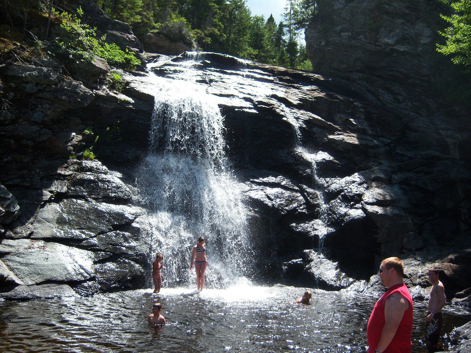
Gordon Falls is a Canadian waterfall in Albert County, New Brunswick. Located off River Road just south from Elgin, the falls are part of the Pollett River, which flows between Elgin and Salisbury. The falls are located by the stone bridge, which crosses the Pollett River. The falls are surrounded by cliffs measuring 10–20 meters (33–66 ft), making it a popular destination for swimming and cliff jumping. The area has been subject to major safety concerns by locals due to the amount of incidents and accidents resulting in people being injured or killed.
The Setting
Gordon Falls sits at 115 metres in the coastal lowlands of New Brunswick. The falls drop 6 metres.
Why This Waterfall Exists
Gordon Falls flows over hard intrusive rock laid down about 539 million to 1.0 billion years ago. These resistant rocks form a durable ledge that water cannot easily wear away, creating a 20-foot drop where softer material downstream has already eroded.
Nearby Falls Worth Visiting
Laverty Falls (12 m) lies 13.7 kilometres to the southeast.
Trail & Hike Details
Trail Description
Approach is likely a very short walk from a roadside pullout or small informal lot to a stream bank. Expect an unpaved, potentially uneven path with roots and rocks; the final viewing area may require stepping on damp rocks or a short scramble to find a clear view. There are likely no constructed viewing platforms or maintained boardwalks.
What to Expect
The falls drop a gentle 6 metres over hard intrusive rock.
Accessibility
The trail involves steep, uneven terrain with significant elevation change and is not accessible to mobility devices.
Frequently Asked Questions
🐶 Are Dogs Allowed at Gordon Falls?
❌ Dogs are not allowed
Are There Any Fees or Permits Required?
🆖 No fees required
🏊 Is There Swimming at Gordon Falls?
❌ Swimming is not allowed
When to Visit
Spring (for highest water flow) and fall (for cooler weather and foliage). Summer offers easier access but potentially reduced flow. Winter can be scenic if ice has formed, but access and footing may be hazardous.
Seasonal Access
The best time to visit is Spring, Summer, Fall, and Winter. Check with the managing park or local authority for current conditions.
Safety Information
• Rocks and banks around waterfalls can be extremely slippery, stay on stable ground. • Stream flow can increase rapidly after rain; avoid getting too close to fast water. • No guaranteed cell coverage, tell someone your plans and expected return time. • Hypothermia risk in cold water; do not attempt crossings unless safe. • Watch for ticks in spring/summer and use insect repellant as needed.
7-Day Flow Outlook
Based on the WSC gauge HOLMES BROOK SITE NO. 9 NEAR PETITCODIAC (12 km away).
Best time of year: this gauge typically runs highest from late March to mid May, peaking in April.
How we calculate this
This is a transparent outlook, not a precise forecast. We take the waterfall's current flow strength (how it ranks against its historical normal for today, from the nearest WSC stream gauge), carry that ranking forward along the gauge's seasonal curve, and nudge it for forecast rain. Confidence is highest for the next day or two and falls further out. Always check official conditions and your own judgment before visiting — high flows can be dangerous.
Know when to go.
Get a free email alert when waterfalls near Moncton hit peak flow. We only send when conditions are worth the trip — no weekly newsletters, no spam.
Weather Forecast
Location & Access
Getting There
Use GPS to navigate to 45.7856, -65.0955. The site is roughly 28 miles from Moncton, about 40 miles from Amherst, and about 69 miles from Saint John. Access is likely by local roads; there may not be formal signage. Expect rural roads and use a map/GPS for the final approach.
Get Directions on Google MapsParking
There may be limited or informal roadside parking near the approach. A formal parking lot or facilities are not confirmed, plan for limited space and do not block driveways or farm entrances.
Elevation
115 metres above sea level
Coordinates
45.785640° N, -65.095521° W
Visitor Tips & Gear
• Wear sturdy, waterproof footwear with good traction, rocks and trails may be slippery. • Assume there are no facilities: bring water, pack out trash, and use leave-no-trace practices. • Exercise caution near edges and wet rocks; banks may be unstable. • Expect variable flow depending on season and recent precipitation. • If visiting in spring or winter, be prepared for muddy or icy conditions. • Respect private property, stay on public right-of-way and do not trespass.
Where to Stay
Browse vacation cabins and private rentals nearby
Unique outdoor stays — tents, yurts, and treehouses
Rent a campervan or RV for your waterfall road trip
Some links are affiliate links. We may earn a commission at no extra cost to you.
Nearby Campground
Camp Whisong - Girl Guides
4.2 km away
Additional Information
Nearby Attractions
Nearest larger service centers: Moncton (approx. 28 miles) for lodging, food, and tourist sites. The Bay of Fundy coastline and related attractions (e.g., Hopewell Rocks) are in the broader region but are a longer drive, check distances and routing beforehand.
Wildlife
Typical southeastern New Brunswick wildlife may be present: songbirds, waterfowl, white-tailed deer, small mammals, and potentially black bears. Take usual precautions for wildlife (store food, keep distance). Watch for ticks in warmer months.
Cities near Gordon Falls
Nearby Waterfalls
Other waterfalls named Gordon Falls
2 other waterfalls share this name across Canada.
Writing about Gordon Falls? Embed this waterfall on your site for free.