Difficulty
Easy
Trail Length
1.0 km
Trail Type
Out And Back
About Gibson Fall's
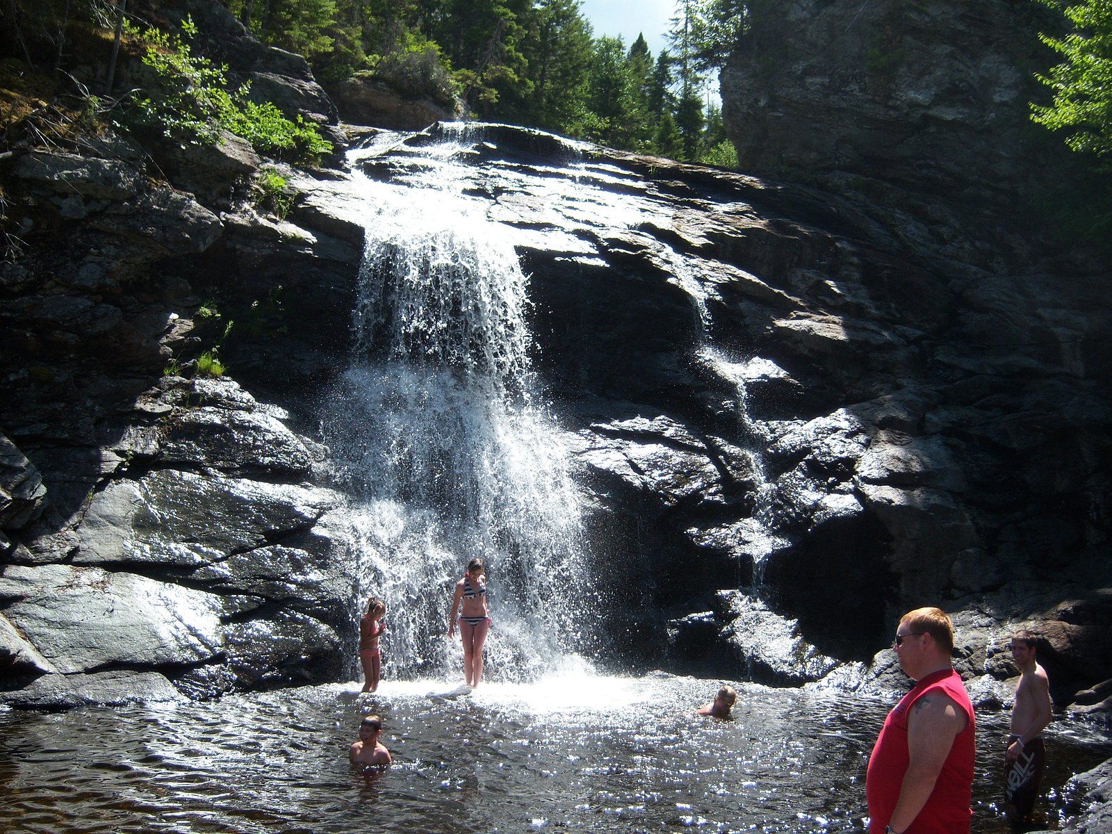
Gibson Falls is a modest, forested waterfall located in southeastern New Brunswick (approximate coordinates 45.7825, -65.0925). It is situated in a rural/wooded landscape roughly 27.8 miles from Moncton, 39.7 miles from Amherst, and 69.4 miles from Saint John. The falls appear from visitor reports and regional mapping to be a smaller cascade or drop set within a stream corridor and may be most noteworthy for its secluded setting and seasonal flow. Specific documented details (exact drop, official trail name) are limited; some access may be via informal or lightly developed trails.
Why This Waterfall Exists
Gibson Fall's flows over hard intrusive rock laid down about 539 million to 1.0 billion years ago. These resistant rocks form a durable ledge that water cannot easily wear away, creating the falls where softer material downstream has already eroded.
Nearby Falls Worth Visiting
Laverty Falls (12 m) lies 13.4 kilometres to the southeast. Also nearby: Gordon Falls (6 m, 0.5 km).
Trail & Hike Details
Trail Description
Trail information for Gibson Falls is not well documented in major trail databases. Expect an informal or lightly maintained footpath through mixed forest with roots and rocks; sections may be narrow and possibly steep near the water. There may be short scramble sections or wooden steps, but specific features (distance, official markers) are not consistently reported. Use GPS coordinates or local directions to locate the access point, and be prepared for minimal infrastructure.
What to Expect
A small, wooded waterfall setting that typically has higher flow in spring and after rain. The immediate area is likely shaded with mossy rocks and a stream channel. Trails may be muddy, uneven, and narrow. Expect limited facilities (no restrooms or visitor centre), variable cell coverage, and few other developed amenities. Seasonal conditions (ice in winter, high water in spring) can change access and safety.
Accessibility
The trail is short and relatively flat, but the surface may be uneven. Contact the managing agency for accessibility details.
Frequently Asked Questions
🐶 Are Dogs Allowed at Gibson Fall's?
❌ Dogs are not allowed
Are There Any Fees or Permits Required?
🆖 No fees required
🏊 Is There Swimming at Gibson Fall's?
❌ Swimming is not allowed
When to Visit
Late spring (snowmelt and spring rains) typically offers the strongest flows. Early fall provides good weather and foliage color. Summer is fine for access but flow may be lower in dry periods. Winter visits are possible but may require traction devices and present icy, hazardous conditions.
Seasonal Access
The best time to visit is Spring, Summer, Fall, and Winter. Check with the managing park or local authority for current conditions.
Safety Information
Hazards to be aware of: slippery and unstable rocks near the water; steep or unmarked dropoffs; changing water levels and strong currents after heavy rain; icy conditions in winter; limited or no cell service in some spots; possible encounter with wildlife. Do not climb on wet rocks near edges, supervise children closely, and avoid swimming unless conditions are known to be safe. If access crosses or borders private land, respect posted signs and property boundaries. Check local weather and trail conditions before visiting.
7-Day Flow Outlook
Based on the WSC gauge HOLMES BROOK SITE NO. 9 NEAR PETITCODIAC (12 km away).
Best time of year: this gauge typically runs highest from late March to mid May, peaking in April.
How we calculate this
This is a transparent outlook, not a precise forecast. We take the waterfall's current flow strength (how it ranks against its historical normal for today, from the nearest WSC stream gauge), carry that ranking forward along the gauge's seasonal curve, and nudge it for forecast rain. Confidence is highest for the next day or two and falls further out. Always check official conditions and your own judgment before visiting — high flows can be dangerous.
Know when to go.
Get a free email alert when waterfalls near Moncton hit peak flow. We only send when conditions are worth the trip — no weekly newsletters, no spam.
Weather Forecast
Location & Access
Getting There
Use the provided coordinates (45.7825, -65.0925) in a GPS device. From Moncton (≈27.8 miles) drive generally west/northwest on the Trans‑Canada Highway (Route 2) toward local roads that lead into rural areas near the coordinates; from Amherst (≈39.7 miles) approach via Route 2 eastbound. From Saint John (≈69.4 miles) follow the Trans‑Canada/Route 2 northeast toward the Moncton region. Once near the coordinates expect to use secondary paved or gravel roads; signage may be minimal. Follow local access rules and respect private property if the trailhead is adjacent to private land.
Get Directions on Google MapsParking
Parking information is limited. Visitors report small pull‑outs or informal parking near a trailhead or roadside; spaces may be unmarked and limited. Park fully off the roadway, avoid blocking driveways, and do not park where it would create a hazard. If you find a constructed parking area, use it. If unsure about ownership of adjacent land, look for posted signs or contact local municipal offices.
Elevation
158 metres above sea level
Coordinates
45.782516° N, -65.092451° W
Visitor Tips & Gear
1) Use the provided coordinates and verify with recent local maps or municipal information before visiting. 2) Wear sturdy, waterproof footwear with good traction; expect muddy and uneven ground. 3) Avoid cliff edges and slippery rocks near the water. 4) Park well off the road and avoid blocking access. 5) Check for private property signs and obtain permission if access crosses private land. 6) Carry insect repellent (ticks and mosquitoes can be present) and a small first‑aid kit. 7) Let someone know your plans if visiting remote spots and consider a charged phone and map.
Where to Stay
Browse vacation cabins and private rentals nearby
Unique outdoor stays — tents, yurts, and treehouses
Rent a campervan or RV for your waterfall road trip
Some links are affiliate links. We may earn a commission at no extra cost to you.
Nearby Campground
Camp Whisong - Girl Guides
4.6 km away
Additional Information
Nearby Attractions
Regional attractions include Magnetic Hill and the Magnetic Hill Zoo (Moncton area) and the Bay of Fundy attractions such as Hopewell Rocks further to the southeast. Specific distances and attractions will depend on your exact route; verify with local tourism resources for up‑to‑date information.
Wildlife
Typical wildlife of southern New Brunswick: white‑tailed deer, moose (less common near smaller streams but possible), black bears (possible in forested areas), small mammals, and numerous bird species. Ticks are present in the region, take precautions against Lyme disease. Mosquitoes can be abundant in warm months.
Cities near Gibson Fall's
Nearby Waterfalls
Writing about Gibson Fall's? Embed this waterfall on your site for free.