Fiddlehead Falls
By Armen Suny · Last verified Jun 2026
Photo Credits (1)
Difficulty
Moderate
Trail Length
1.3 km
Trail Type
Out And Back
Elevation Gain
46 m
About Fiddlehead Falls
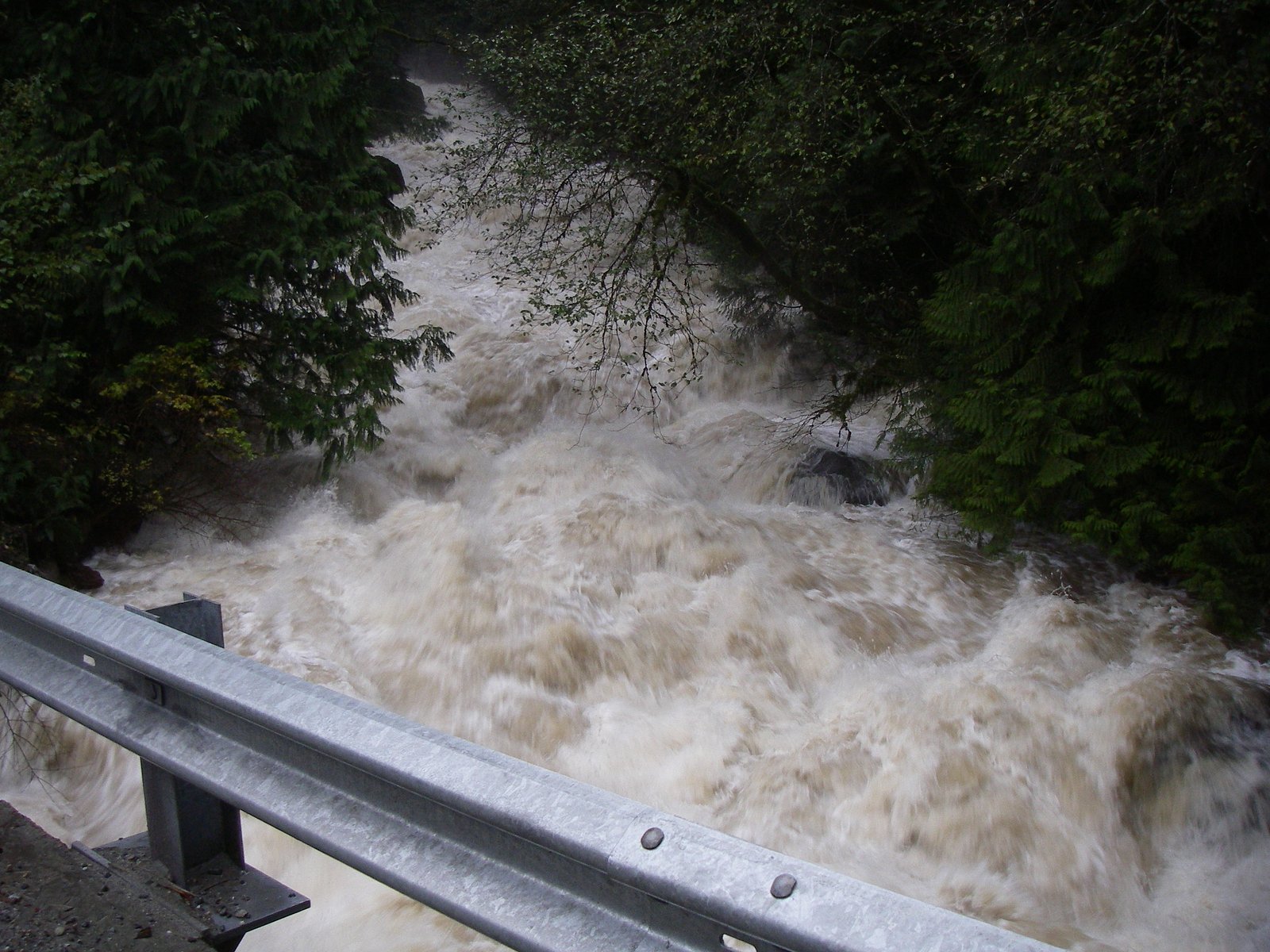
Fiddlehead Falls is a small forested waterfall in the Fraser Valley region of British Columbia. It is described in local trip reports as a multi-tiered cascade set in a mossy, tree-lined creek or stream. Specifics on official management, posted trails, and exact measured height are not widely published online; visitor accounts suggest a relatively modest-height fall rather than a large canyon waterfall. The coordinates provided (49.2824, -122.3707) place the feature in the general Abbotsford/Fraser Valley area, visitors should confirm the exact access point before visiting.
Why This Waterfall Exists
Fiddlehead Falls flows over hard intrusive rock laid down about 145-175 million years ago. These resistant rocks form a durable ledge that water cannot easily wear away, creating the falls where softer material downstream has already eroded.
Nearby Falls Worth Visiting
Upper Kanaka Falls (25 m) lies 6.6 kilometres to the southwest. Also nearby: Rolley Falls (22 m, 3.5 km) and Rockwell Falls (12 m, 2.4 km).
Trail & Hike Details
The Approach
The moderate 1.3-km out-and-back trail gains 46 metres of elevation on the way to the falls.
Trail Description
There is no widely published, authoritative trail description for Fiddlehead Falls at the supplied coordinates. Based on typical small falls in the region, access may involve a short forested path, rough footpath, or scramble down a stream bank. Trails may be unmaintained and could include roots, mud, and steep sections. If you find a marked trail on local trail guides or AllTrails, follow that route and any posted signs.
What to Expect
Expect a woodland setting with streamside vegetation, moss-covered rocks, and a multi-step cascade rather than a single high plunge. Flow is likely seasonal, higher in spring and after significant rain, lower in late summer and drought periods. Trails (if present) may be narrow and muddy; there may be limited signage, cell reception can be intermittent, and access may pass near private land or forestry operations.
Accessibility
The trail is not wheelchair accessible. Uneven terrain and elevation changes require steady footing.
Frequently Asked Questions
🐶 Are Dogs Allowed at Fiddlehead Falls?
❌ Dogs are not allowed
Are There Any Fees or Permits Required?
🆖 No fees required
🏊 Is There Swimming at Fiddlehead Falls?
❌ Swimming is not allowed
When to Visit
Late spring (snowmelt and seasonal rain) typically offers the highest flows and most impressive appearance. Early summer can be good if recent rains have occurred. Avoid periods of heavy rain for safety (high flows and slippery conditions) and be cautious in winter where ice can form.
Seasonal Access
The best time to visit is Spring, Summer, and Fall. Winter access may be limited. Check with the managing park or local authority for current conditions.
Safety Information
Possible hazards include slippery rocks, steep or unstable banks, fast or cold water, seasonal high flows, and limited or no formal trail maintenance. Access may cross private or industrial lands with active logging or gated roads, do not trespass. Wear appropriate footwear, avoid cliff edges, supervise children closely, and do not attempt river crossings during high water. Check recent trip reports for current conditions and any posted warnings.
Current Water Conditions
0.2 m³/s
Current discharge — how much water is flowing
Lower than usual for this time of year
Based on 64 years of record
0.84 m
Water depth at gauge
7-Day Discharge Trend
What does this mean for your visit?
Flow is lower than usual for this time of year.
About This Gauge
This gauge is on a nearby waterway and may not reflect exact conditions at the falls.
7-Day Flow Outlook
Based on the WSC gauge KANAKA CREEK NEAR WEBSTER CORNERS (15 km away).
Today
Low
0.2 m³/s
5/10Tomorrow
Low
0.2 m³/s
5/10Tue
Low
0.2 m³/s
5/10Wed
Low
0.1 m³/s
5/10Thu
Moderate
0.2 m³/s
5/10Fri
Moderate
0.1 m³/s
6/10Sat
Moderate
0.1 m³/s
5/10Best window: Fri — moderate flow, cloudy (trip score 6/10).
Best time of year: this gauge typically runs highest from early November to late December, peaking in December.
How we calculate this
This is a transparent outlook, not a precise forecast. We take the waterfall's current flow strength (how it ranks against its historical normal for today, from the nearest WSC stream gauge), carry that ranking forward along the gauge's seasonal curve, and nudge it for forecast rain. Confidence is highest for the next day or two and falls further out. Always check official conditions and your own judgment before visiting — high flows can be dangerous.
Know when to go.
Get a free email alert when waterfalls near Abbotsford hit peak flow. We only send when conditions are worth the trip — no weekly newsletters, no spam.
Weather Forecast
Location & Access
Getting There
General location: ~14.3 miles from Abbotsford, BC, with coordinates 49.2824, -122.3707 (user-supplied). Access details are not clearly documented in official provincial park materials. Many local waterfalls in the Fraser Valley are reached via short forested trails or unpaved logging/FS roads and may cross or be adjacent to private property. Before traveling, check official regional park websites, local hiking guides (AllTrails reports if available), or contact municipal/park authorities to confirm the access route and land ownership.
Get Directions on Google MapsParking
Parking information is not clearly documented. Expect either a small pullout on a minor road, informal parking at a trailhead, or no formal parking. Do not block gates, driveways, or private property. If visiting, use official trailhead lots when available and confirm parking rules with local authorities.
Elevation
291 metres above sea level
Coordinates
49.282443° N, -122.370749° W
Visitor Tips & Gear
• Confirm exact location and legal access before visiting, some nearby waterfalls are on private or lease-held land. • Wear sturdy, waterproof footwear with good traction; expect mud and slippery rocks. • Bring a map or GPS (use the provided coordinates), and tell someone your plans. • Park only in designated areas; do not block gates or access roads. • Avoid approaching the edge of the falls on wet or icy surfaces. • Leave no trace: pack out trash and avoid disturbing vegetation. • Check local trail reports (AllTrails, regional park sites) for recent conditions and hazards.
As an Amazon Associate, we earn from qualifying purchases.
With 1.3 km and 46 m of elevation gain, sturdy boots and trekking poles will help on this moderate trail. Sun exposure on the trail makes good sun protection a must in summer.

Polarized Sunglasses (Knockaround)
Cuts glare off the water so you actually see the falls — and your photos turn out better too.

Columbia Watertight II Rain Jacket
Packs into its own pocket, seam-sealed, and keeps you dry from spray and surprise rain.

Earth Pak Waterproof Dry Bag
Keeps your phone and gear dry when waterfall mist soaks everything else.

Waterproof Phone Pouch (AiRunTech)
Cheap insurance — take photos right next to the falls without killing your phone.

Timberland Euro Sprint Mid Waterproof
Trusted waterproof boot with premium leather and grippy rubber sole — reliable on rocky, wet trails.

TrailBuddy Trekking Poles
Lightweight aluminum, cork grips, and flip-locks that actually hold — a best-seller for good reason.
Where to Stay
Browse vacation cabins and private rentals nearby
Unique outdoor stays — tents, yurts, and treehouses
Rent a campervan or RV for your waterfall road trip
Some links are affiliate links. We may earn a commission at no extra cost to you.
Nearby Campground
Rock Creek Recreation Site
1.4 km away
Nearby Hot Springs
Hot springs near Abbotsford, British Columbia
Dorr Fumarole Field
Dorr Fumarole Field reaches 194 degrees at 8,168 feet elevation on Mount Baker's active volcanic slopes, producing superheated ...

Sherman Crater Fumaroles
Sherman Crater Fumaroles register 266 degrees Fahrenheit at 9,463 feet elevation within the active volcanic crater atop Mount B...
Baker Hot Spring
Baker Hot Spring emerges at 108 degrees Fahrenheit on US Forest Service land in Mt. Baker National Forest, flowing 59.5 degrees...
Looking for a soak after your hike? Explore more hot springs near Abbotsford, British Columbia on SoakingSprings.
Explore British Columbia springsAdditional Information
Nearby Attractions
Nearby regional attractions may include parts of the Fraser Valley, local parks and trails near Abbotsford, Sumas Mountain recreational areas, and river access points in the Vedder/Chilliwack region. Exact nearby trailheads depend on confirmed location and route.
Wildlife
Typical Fraser Valley/Lower Mainland wildlife may be present: black bears, coyotes, deer, raccoons, and numerous bird species. Salmon runs may occur in some regional streams (check local waterways). Be bear-aware where appropriate and store food securely.
Cities near Fiddlehead Falls
Nearby Waterfalls
Writing about Fiddlehead Falls? Embed this waterfall on your site for free.