Dog Mountain Falls
By Armen Suny · Last verified Jun 2026
Difficulty
Moderate
Trail Length
2.3 km
Trail Type
Loop
Elevation Gain
213 m
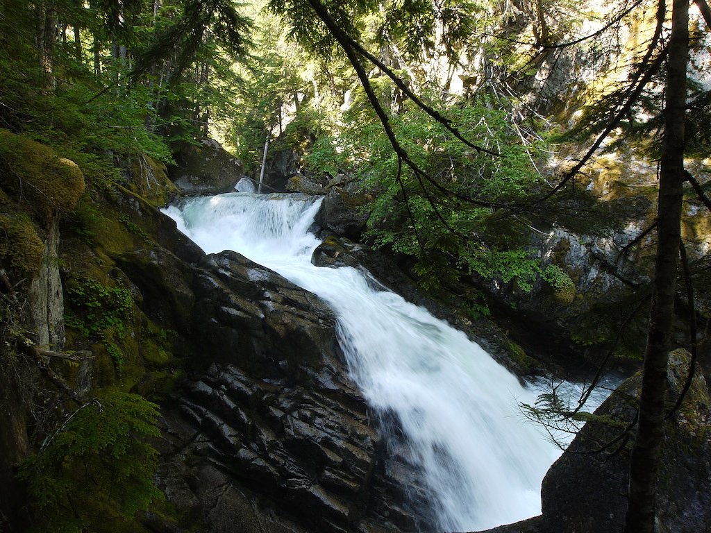
About Dog Mountain Falls
Dog Mountain Falls is a small forested cascade located near coordinates 49.3913, -121.4792 in the general Harrison/Chilliwack area of British Columbia. The waterfall appears to be a multi-step cascade through mixed conifer forest and likely sees its highest flows in spring and early summer. Specific published measurements and official park listings for this feature are limited; the following description is conservative and includes language where details are uncertain.
Why This Waterfall Exists
Dog Mountain Falls flows over hard intrusive rock laid down about 66-145 million years ago. These resistant rocks form a durable ledge that water cannot easily wear away, creating the falls where softer material downstream has already eroded.
Nearby Falls Worth Visiting
Chawuthen Creek Falls (20 m) lies 4.2 kilometres to the southwest.
Trail & Hike Details
The Approach
The moderate 2.3-km loop trail gains 213 metres of elevation on the way to the falls.
Trail Description
Trail information is not well documented in official park sources. Approaches to Dog Mountain Falls may follow an unmaintained or lightly maintained footpath from a roadside parking area or a short network of logging/access roads. Expect uneven footing, roots, rocks, and potentially steep or muddy sections. The route is likely out-and-back in character, but an official marked loop is not known.
What to Expect
A forested setting with one or more cascade drops over bedrock. Flow varies seasonally (typically higher in spring/early summer and lower in late summer/fall). Trails and rocks near the falls can be slippery and wet. Facilities (toilets, signage, maintained viewpoints) are likely minimal or absent. Cell service may be intermittent.
Accessibility
The trail is not wheelchair accessible. Uneven terrain and elevation changes require steady footing.
Frequently Asked Questions
🐶 Are Dogs Allowed at Dog Mountain Falls?
❌ Dogs are not allowed
Are There Any Fees or Permits Required?
🆖 No fees required
🏊 Is There Swimming at Dog Mountain Falls?
❌ Swimming is not allowed
When to Visit
Late spring to early summer for the best water flow and scenic conditions. Late summer offers easier, drier trail conditions but lower flows. Fall can provide good colors but expect wetter, muddier trails. Winter visits may be hazardous due to snow, ice, or closed access roads.
Seasonal Access
The best time to visit is Spring, Summer, and Fall. Winter access may be limited. Check with the managing park or local authority for current conditions.
Safety Information
Hazards include slippery wet rock, steep or unstable banks, sudden increases in stream flow after rain, limited or no cell reception, and potentially hazardous access roads. Dress for changing weather, use caution near edges and pools, travel with a partner when possible, and tell someone your route and expected return time. If unfamiliar with logging roads, confirm seasonal closures and permissions before driving them.
Current Water Conditions
3,670.0 m³/s
Current discharge — how much water is flowing
Much lower than usual for this time of year
Based on 113 years of record
5.65 m
Water depth at gauge
7-Day Discharge Trend
What does this mean for your visit?
Flow is well below normal for this time of year, so the waterfall may be a trickle.
About This Gauge
7-Day Flow Outlook
Based on the WSC gauge FRASER RIVER AT HOPE (2 km away).
Today
Barely Flowing
3670 m³/s
5/10Tomorrow
Barely Flowing
3584 m³/s
4/10Tue
Barely Flowing
3562 m³/s
4/10Wed
Barely Flowing
3504 m³/s
4/10Thu
Barely Flowing
3425 m³/s
4/10Fri
Barely Flowing
3382 m³/s
5/10Sat
Barely Flowing
3567 m³/s
3/10Best window: Today — barely flowing flow, mainly sunny (trip score 5/10).
Best time of year: this gauge typically runs highest from early May to early August, peaking in June.
How we calculate this
This is a transparent outlook, not a precise forecast. We take the waterfall's current flow strength (how it ranks against its historical normal for today, from the nearest WSC stream gauge), carry that ranking forward along the gauge's seasonal curve, and nudge it for forecast rain. Confidence is highest for the next day or two and falls further out. Always check official conditions and your own judgment before visiting — high flows can be dangerous.
Know when to go.
Get a free email alert when waterfalls near Chilliwack hit peak flow. We only send when conditions are worth the trip — no weekly newsletters, no spam.
Weather Forecast
Location & Access
Getting There
Access is typically from local forest or secondary roads branching off the main highways serving the Harrison/Chilliwack region. Expect a short drive on unpaved or logging roads in some cases and then a trail or rough footpath to the falls. Use the provided coordinates (49.3913, -121.4792) in a GPS unit. Verify current road conditions and permissions before driving on resource roads.
Get Directions on Google MapsParking
Parking is likely limited and informal (roadside or small pullouts). Some approaches may require parking at a trailhead or turnout and walking on a logging road. Do not block gates or private driveways. Check for posted signs and local access restrictions.
Elevation
361 metres above sea level
Coordinates
49.391312° N, -121.479226° W
Visitor Tips & Gear
• Check recent trip reports or local trail resources (AllTrails, regional hiking forums, or B.C. recreation pages) before you go. • Wear sturdy, grippy footwear, wet rocks and roots are common. • Bring a map and/or download offline maps; GPS coordinates are useful. • Leave no trace: pack out what you bring in. • Avoid approaching the edge of any cliffs or unstable banks. • Be cautious after heavy rain, stream flows and river levels can rise quickly. • If you plan to use logging/resource roads, confirm they are open to public traffic.
As an Amazon Associate, we earn from qualifying purchases.
With 2.3 km and 213 m of elevation gain, sturdy boots and trekking poles will help on this moderate trail. Sun exposure on the trail makes good sun protection a must in summer.

Columbia Watertight II Rain Jacket
Packs into its own pocket, seam-sealed, and keeps you dry from spray and surprise rain.

Earth Pak Waterproof Dry Bag
Keeps your phone and gear dry when waterfall mist soaks everything else.

Waterproof Phone Pouch (AiRunTech)
Cheap insurance — take photos right next to the falls without killing your phone.

Timberland Euro Sprint Mid Waterproof
Trusted waterproof boot with premium leather and grippy rubber sole — reliable on rocky, wet trails.

TrailBuddy Trekking Poles
Lightweight aluminum, cork grips, and flip-locks that actually hold — a best-seller for good reason.

Polarized Sunglasses (Knockaround)
Cuts glare off the water so you actually see the falls — and your photos turn out better too.
Where to Stay
Browse vacation cabins and private rentals nearby
Unique outdoor stays — tents, yurts, and treehouses
Rent a campervan or RV for your waterfall road trip
Some links are affiliate links. We may earn a commission at no extra cost to you.
Nearby Campground
Telte-Yet
2.5 km away
Nearby Hot Springs
Hot springs near Chilliwack, British Columbia
Baker Hot Spring
Baker Hot Spring emerges at 108 degrees Fahrenheit on US Forest Service land in Mt. Baker National Forest, flowing 59.5 degrees...
Dorr Fumarole Field
Dorr Fumarole Field reaches 194 degrees at 8,168 feet elevation on Mount Baker's active volcanic slopes, producing superheated ...

Sherman Crater Fumaroles
Sherman Crater Fumaroles register 266 degrees Fahrenheit at 9,463 feet elevation within the active volcanic crater atop Mount B...
Looking for a soak after your hike? Explore more hot springs near Chilliwack, British Columbia on SoakingSprings.
Explore British Columbia springsAdditional Information
Nearby Attractions
Nearby regional attractions include Harrison Hot Springs and the broader Fraser Valley recreational areas. Chilliwack and local provincial parks (e.g., hiking routes and viewpoints) are within regional driving distance. Verify exact distances and access for other attractions before planning.
Wildlife
Typical coastal/mountain wildlife may be present: black bears, coyotes, cougars (rare), deer, small mammals, and a variety of forest birds and amphibians. Take bear-aware precautions in bear country and store food properly.
Cities near Dog Mountain Falls
Nearby Waterfalls
Writing about Dog Mountain Falls? Embed this waterfall on your site for free.