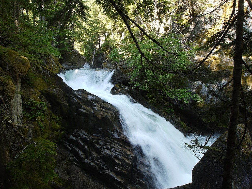
Chawuthen Creek Falls
British Columbia • 20 m
By Armen Suny · Last verified Jun 2026
Difficulty
Moderate
Trail Length
2.6 km
Trail Type
Out And Back
About Chawuthen Creek Falls
Chawuthen Creek Falls is a forested, likely seasonal waterfall located in the Chilliwack area of southwestern British Columbia (coordinates: 49.3572, -121.5055). Reports and local references indicate this is a relatively remote, less-developed waterfall that may require route-finding, travel on forestry or logging roads, and a short off-trail scramble to reach the creek and viewing points. Flow is likely highest in spring during snowmelt and after heavy rain; summer flows may be reduced.
The Setting
Chawuthen Creek Falls sits at 192 metres within Old Growth Management Areas (Mapped Legal), in the foothills of British Columbia. The falls drop 20 metres.
Why This Waterfall Exists
Chawuthen Creek Falls flows over hard intrusive rock laid down about 66-145 million years ago. These resistant rocks form a durable ledge that water cannot easily wear away, creating a 65-foot drop where softer material downstream has already eroded.
Trail & Hike Details
Trail Description
There is no widely-published, maintained trail description for Chawuthen Creek Falls. Based on available location context and reports for similar remote creek falls in the region, expect a route that includes travel on an unpaved forestry road followed by an unmarked or lightly used footpath and possible short off-trail scrambling through forest to the creek. Trail may be wet, steep in places, and involve route-finding across fallen logs and uneven terrain. Wayfinding skills and a map/GPS are recommended.
What to Expect
The falls drop 20 metres over hard intrusive rock.
Accessibility
The trail is not wheelchair accessible. Uneven terrain and elevation changes require steady footing.
Frequently Asked Questions
🐶 Are Dogs Allowed at Chawuthen Creek Falls?
❌ Dogs are not allowed
Are There Any Fees or Permits Required?
🆖 No fees required
🏊 Is There Swimming at Chawuthen Creek Falls?
❌ Swimming is not allowed
When to Visit
Late spring (snowmelt) through early summer usually provides the most robust flow and most dramatic water levels. Early fall can offer lower flows with fewer bugs and fewer visitors. Avoid visiting after heavy rain without caution due to potential flashy creek flows and slippery conditions.
Seasonal Access
The best time to visit is Spring, Summer, Fall, and Winter. Check with the managing park or local authority for current conditions.
Safety Information
Hazards can include slippery rocks, steep or unstable banks, sudden increases in water flow after rain, loose rock, poor or no cell coverage, and hazardous driving on unpaved forestry roads. Flying or falling debris and active logging operations may create dangers. Always check weather, wear appropriate footwear, avoid the water edge when flows are high, and do not attempt technical climbs without proper gear and experience.
Current Water Conditions
3,670.0 m³/s
Current discharge — how much water is flowing
Much lower than usual for this time of year
Based on 113 years of record
5.65 m
Water depth at gauge
7-Day Discharge Trend
What does this mean for your visit?
Flow is well below normal for this time of year, so the waterfall may be a trickle.
About This Gauge
7-Day Flow Outlook
Based on the WSC gauge FRASER RIVER AT HOPE (5 km away).
Today
Barely Flowing
3670 m³/s
5/10Tomorrow
Barely Flowing
3584 m³/s
4/10Tue
Barely Flowing
3562 m³/s
4/10Wed
Barely Flowing
3504 m³/s
4/10Thu
Barely Flowing
3425 m³/s
4/10Fri
Barely Flowing
3382 m³/s
5/10Sat
Barely Flowing
3567 m³/s
3/10Best window: Today — barely flowing flow, sunny (trip score 5/10).
Best time of year: this gauge typically runs highest from early May to early August, peaking in June.
How we calculate this
This is a transparent outlook, not a precise forecast. We take the waterfall's current flow strength (how it ranks against its historical normal for today, from the nearest WSC stream gauge), carry that ranking forward along the gauge's seasonal curve, and nudge it for forecast rain. Confidence is highest for the next day or two and falls further out. Always check official conditions and your own judgment before visiting — high flows can be dangerous.
Know when to go.
Get a free email alert when waterfalls near Chilliwack hit peak flow. We only send when conditions are worth the trip — no weekly newsletters, no spam.
Weather Forecast
Location & Access
Getting There
Use the provided coordinates (49.3572, -121.5055) in a reliable GPS or mapping app. The waterfall is in a forested area north of Chilliwack and is most commonly accessed from local forest/forestry roads and secondary trails. Expect unpaved roads that may require a high-clearance vehicle; some sections may be passable only on foot. Exact public trailheads and formal access routes are not well-documented, approach cautiously and verify current road and land-access conditions with local authorities or land managers before visiting.
Get Directions on Google MapsParking
Parking is likely informal (small roadside or at the end of a forestry road). There may be no official lot, signage, or facilities. Park legally and avoid blocking gates or driveways. If access crosses private land, permission may be required.
Elevation
192 metres above sea level
Coordinates
49.357172° N, -121.505523° W
Land Management
Managed by Government of British Columbia
Visitor Tips & Gear
• Use the exact GPS coordinates and a topographic map or offline mapping app. • Travel with a companion if possible and tell someone your route and expected return time. • Wear sturdy, waterproof footwear with good traction. • Bring topographic map, compass or GPS, and basic route-finding tools. • Pack bear spray and know how to use it; store food securely. • Avoid approaching slippery edges and wet rocks; do not climb on unstable ledges. • Respect private property and forestry operations, if gates are locked or signs indicate private land, do not trespass. • Practice Leave No Trace, pack out all trash.
Where to Stay
Browse vacation cabins and private rentals nearby
Unique outdoor stays — tents, yurts, and treehouses
Rent a campervan or RV for your waterfall road trip
Some links are affiliate links. We may earn a commission at no extra cost to you.
Nearby Campground
Wild Rose Camping and RV Park
1.1 km away
Nearby Hot Springs
Hot springs near Chilliwack, British Columbia
Baker Hot Spring
Baker Hot Spring emerges at 108 degrees Fahrenheit on US Forest Service land in Mt. Baker National Forest, flowing 59.5 degrees...
Dorr Fumarole Field
Dorr Fumarole Field reaches 194 degrees at 8,168 feet elevation on Mount Baker's active volcanic slopes, producing superheated ...

Sherman Crater Fumaroles
Sherman Crater Fumaroles register 266 degrees Fahrenheit at 9,463 feet elevation within the active volcanic crater atop Mount B...
Looking for a soak after your hike? Explore more hot springs near Chilliwack, British Columbia on SoakingSprings.
Explore British Columbia springsAdditional Information
Nearby Attractions
General nearby points of interest in the broader Chilliwack region include Chilliwack River valley recreation areas, Bridal Veil Falls Provincial Park, Chilliwack Lake Provincial Park, and hiking routes on Mount Cheam. Exact proximity to specific attractions will vary; verify directions and distances locally.
Wildlife
Black bears and, less commonly, cougars may be present in the region. Other wildlife includes deer, small mammals, amphibians, and various bird species. Take standard precautions for large mammals and ticks.
Cities near Chawuthen Creek Falls
Nearby Waterfalls
Writing about Chawuthen Creek Falls? Embed this waterfall on your site for free.