Difficulty
Easy
Trail Length
1.4 km
Trail Type
Loop
Elevation Gain
30 m
About Dickson Falls
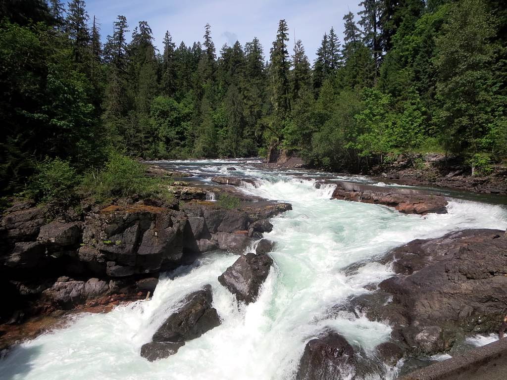
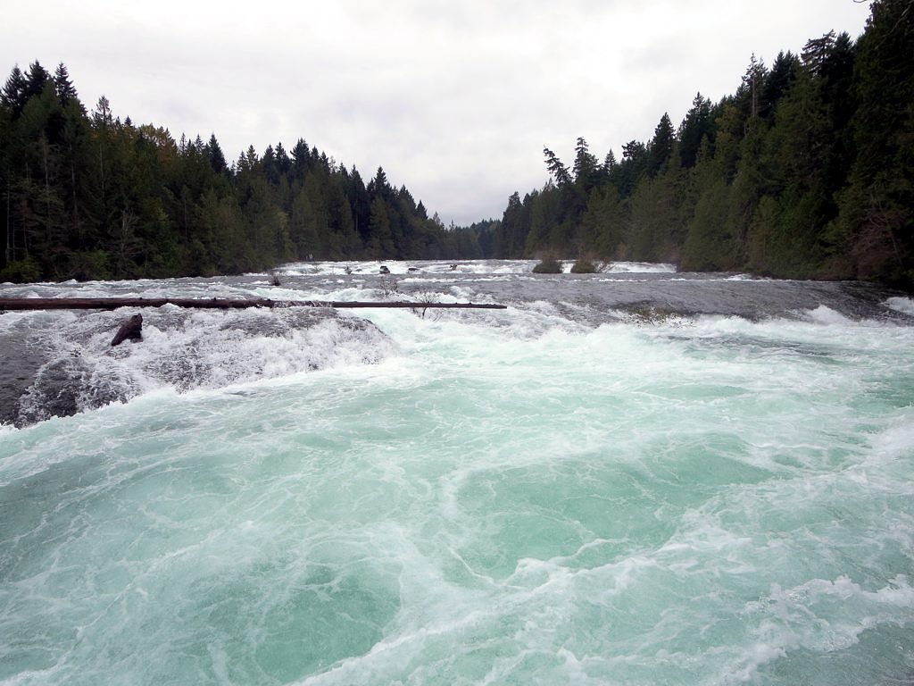
Dickson Falls is a small, scenic cascade located in the Cumberland/Comox Valley area of Vancouver Island, British Columbia. The falls are set in a mossy, second-growth coastal forest and are commonly visited as part of a short loop or out-and-back trail that passes through a narrow gorge with boardwalks and viewing platforms. Flow is typically highest in spring and after heavy rain.
Why This Waterfall Exists
Dickson Falls flows over hard volcanic rock laid down about 201-252 million years ago. These resistant rocks form a durable ledge that water cannot easily wear away, creating the falls where softer material downstream has already eroded.
Trail & Hike Details
The Approach
The easy 1.4-km loop trail gains 30 metres of elevation on the way to the falls.
Trail Description
A short forest walk that loops through second-growth coastal forest to viewpoints over a narrow gorge and a series of cascades. Expect short sections of boardwalk and stairs, damp/muddy trail surfaces in wet weather, and a few short, steeper pitches. The route is well-marked and suitable for most hikers; allow 30–60 minutes depending on stops for photos.
What to Expect
A short, family-friendly forest trail with fern- and moss-covered banks, timber boardwalks, and viewing platforms. The falls consist of cascades in a confined gorge rather than one tall plunge. Trail surfaces can be muddy and slippery when wet; there may be roots and rocks underfoot. Spring and after heavy rains bring the best flows; summer can be lower but still scenic.
Accessibility
The trail is short and relatively flat, but the surface may be uneven. Contact the managing agency for accessibility details.
Frequently Asked Questions
🐶 Are Dogs Allowed at Dickson Falls?
❌ Dogs are not allowed
Are There Any Fees or Permits Required?
🆖 No fees required
🏊 Is There Swimming at Dickson Falls?
❌ Swimming is not allowed
When to Visit
Spring (for highest water flow and lush mossy forest) and early fall (for good flows and cooler hiking conditions). Summer offers easier access and drier trails but lower flows. Winter visits are possible but expect icy, muddy, or storm-impacted conditions, use caution.
Seasonal Access
The best time to visit is Spring, Summer, Fall, and Winter. Check with the managing park or local authority for current conditions.
Safety Information
Hazards include slippery rocks and trails, steep edges at viewpoints, rapidly changing weather, and low light under the canopy. After rain the gorge and boardwalks can be very slick. Cell service may be limited in parts. Keep children close to viewing platforms, do not climb over barriers, and avoid entering fast or cold water. If hiking in bear country, make noise, store food securely, and carry bear spray where recommended. Check recent visitor reports or local park/municipal pages for trail conditions and closures before visiting.
Current Water Conditions
4.7 m³/s
Current discharge — how much water is flowing
About average for this time of year
Based on 63 years of record
0.54 m
Water depth at gauge
7-Day Discharge Trend
What does this mean for your visit?
Flow is about average for this time of year.
About This Gauge
7-Day Flow Outlook
Based on the WSC gauge ASH RIVER BELOW MORAN CREEK (6 km away).
Today
Moderate
4.7 m³/s
8/10Tomorrow
Moderate
4.7 m³/s
9/10Tue
Moderate
4.4 m³/s
8/10Wed
Moderate
4.4 m³/s
8/10Thu
Moderate
4.4 m³/s
8/10Fri
Moderate
4.2 m³/s
8/10Sat
Moderate
4.6 m³/s
6/10Best window: Tomorrow — moderate flow, sunny (trip score 9/10).
Best time of year: this gauge typically runs highest from mid November to late December, peaking in December.
How we calculate this
This is a transparent outlook, not a precise forecast. We take the waterfall's current flow strength (how it ranks against its historical normal for today, from the nearest WSC stream gauge), carry that ranking forward along the gauge's seasonal curve, and nudge it for forecast rain. Confidence is highest for the next day or two and falls further out. Always check official conditions and your own judgment before visiting — high flows can be dangerous.
Know when to go.
Get a free email alert when waterfalls near Courtenay hit peak flow. We only send when conditions are worth the trip — no weekly newsletters, no spam.
Weather Forecast
Location & Access
Getting There
Dickson Falls is located near Cumberland in the Comox Valley on Vancouver Island (coordinates 49.3958, -125.0607). From Courtenay drive toward Cumberland; follow local roads and signs for the Dickson Falls / Cumberland Forest area. There is a small trailhead/parking area off the local access road. Exact driving directions and conditions may change; check local maps or park/municipal pages before travel.
Get Directions on Google MapsParking
There is a small parking area at the trailhead; spaces are limited and may fill on busy days. Park only in designated spots and avoid blocking driveways or gates. On busy weekends you may need to park farther away and walk in.
Elevation
205 metres above sea level
Coordinates
49.395774° N, -125.060721° W
Visitor Tips & Gear
Wear grippy footwear (hiking boots or trail shoes). Expect muddy or wet conditions in the wetter months. Mosquitoes and black flies may be present in spring and summer, bring repellent. Stay on marked trails and viewing platforms; rocks near the water are slippery. Space at the small trailhead is limited, arrive early on weekends. Check local reports for seasonal trail or access changes.
As an Amazon Associate, we earn from qualifying purchases.
For this easy 1.4 km trail, lightweight trail shoes and a water bottle are usually sufficient. Icy conditions are common in winter — traction cleats are a smart addition.

Columbia Watertight II Rain Jacket
Packs into its own pocket, seam-sealed, and keeps you dry from spray and surprise rain.

Earth Pak Waterproof Dry Bag
Keeps your phone and gear dry when waterfall mist soaks everything else.

Waterproof Phone Pouch (AiRunTech)
Cheap insurance — take photos right next to the falls without killing your phone.

Kahtoola MICROspikes
Cult-favorite traction cleats that grip ice and wet rock — essential for winter waterfall hikes.

Polarized Sunglasses (Knockaround)
Cuts glare off the water so you actually see the falls — and your photos turn out better too.

Osprey Daylite Daypack
Light, organized, and just the right size for a day hike — fits water, snacks, and layers.
Where to Stay
Browse vacation cabins and private rentals nearby
Unique outdoor stays — tents, yurts, and treehouses
Rent a campervan or RV for your waterfall road trip
Some links are affiliate links. We may earn a commission at no extra cost to you.
Nearby Campground
Scout Beach Recreation Site
5.8 km away
Additional Information
Nearby Attractions
Cumberland village (local shops and cafes), Cumberland Forest trail network, Comox Valley attractions, Mount Washington Alpine Resort (further inland).
Wildlife
Typical coastal Vancouver Island wildlife may be present: black-tailed deer, various bird species, small mammals, and occasionally black bears or cougars. Streams in the region may support salmon runs at certain times/locations. Maintain distance from wildlife and secure food.
Cities near Dickson Falls
Nearby Waterfalls
Other waterfalls named Dickson Falls
1 other waterfall shares this name across Canada.
Writing about Dickson Falls? Embed this waterfall on your site for free.