Wiener Falls
By Armen Suny · Last verified Jun 2026
Difficulty
Moderate
Trail Length
3.9 km
Trail Type
Out And Back
Elevation Gain
150 m
About Wiener Falls
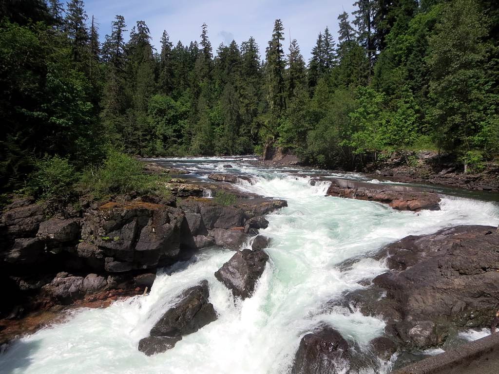
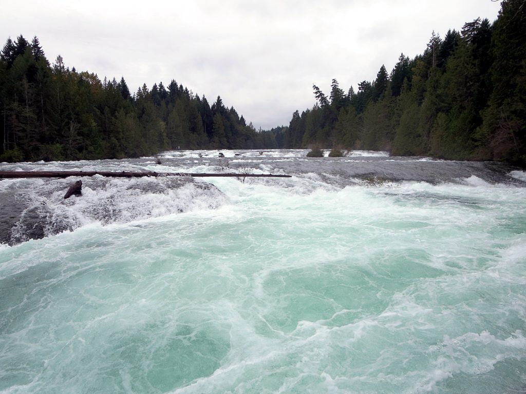
Wiener Falls is a lesser-known waterfall on Vancouver Island, British Columbia, located inland from the eastern coast of the island near Courtenay (approx. 19.2 miles), with coordinates 49.2956, -124.9934. Published information about the falls is limited; it appears to be a forested-ravine cascade on a smaller stream. Visitors' reports indicate that flow and visibility can vary seasonally (higher flows in spring, lower in late summer). Exact measured height and some site details are not well-documented.
Why This Waterfall Exists
Wiener Falls flows over volcanic rock laid down about 201-252 million years ago. These resistant rocks form a durable ledge that water cannot easily wear away, creating the falls where softer material downstream has already eroded.
Trail & Hike Details
The Approach
The moderate 3.9-km out-and-back trail gains 150 metres of elevation on the way to the falls.
Trail Description
Definitive, widely-published trail descriptions are not available for Wiener Falls. If a hiking approach exists it likely traverses forested terrain and may follow an old road or faint footpath down into a ravine. Trails (if present) may be steep in places, uneven, and muddy. Expect limited maintained infrastructure such as stairs, railings, or boardwalks.
What to Expect
Woodland setting typical of eastern Vancouver Island: conifer and mixed forest, moss-covered rocks, ferns, and potentially steep, slippery banks around the creek. Water flow is seasonal, higher in spring and after heavy rains, lower in late summer. There are likely no facilities (toilets, potable water) and cell reception may be spotty. Route-finding skills may be required.
Accessibility
The trail is not wheelchair accessible. Uneven terrain and elevation changes require steady footing.
Frequently Asked Questions
🐶 Are Dogs Allowed at Wiener Falls?
❌ Dogs are not allowed
Are There Any Fees or Permits Required?
🆖 No fees required
🏊 Is There Swimming at Wiener Falls?
❌ Swimming is not allowed
When to Visit
Spring for the most impressive flow (snowmelt and seasonal rain). Summer and early fall may offer easier access and drier trails but lower water volume. Winter visits may be hazardous due to wet/icy conditions, limited daylight, and potential road closures.
Seasonal Access
The best time to visit is Spring, Summer, Fall, and Winter. Check with the managing park or local authority for current conditions.
Safety Information
Potential hazards include slippery rocks and trails, steep or unstable banks near the stream, variable water flow and sudden surges after rain, cold water temperatures, limited cell service, and potential encounters with wildlife. If approaching the water, keep a safe distance from the lip of any drop, avoid cliff edges, and do not climb wet or moss-covered rocks. Carry navigation aids and tell someone your plans. If access requires travel on forestry roads, be aware of heavy vehicle traffic and locked gates.
Current Water Conditions
1.8 m³/s
Current discharge — how much water is flowing
Much lower than usual for this time of year
Based on 102 years of record
0.59 m
Water depth at gauge
7-Day Discharge Trend
What does this mean for your visit?
Flow is well below normal for this time of year, so the waterfall may be a trickle.
About This Gauge
7-Day Flow Outlook
Based on the WSC gauge SPROAT RIVER NEAR ALBERNI (6 km away).
Today
Barely Flowing
1.8 m³/s
4/10Tomorrow
Barely Flowing
1.8 m³/s
5/10Tue
Barely Flowing
1.7 m³/s
4/10Wed
Barely Flowing
1.6 m³/s
4/10Thu
Barely Flowing
1.6 m³/s
4/10Fri
Barely Flowing
1.5 m³/s
4/10Sat
Barely Flowing
1.6 m³/s
3/10Best window: Tomorrow — barely flowing flow, sunny (trip score 5/10).
Best time of year: this gauge typically runs highest from early November to early February, peaking in December.
How we calculate this
This is a transparent outlook, not a precise forecast. We take the waterfall's current flow strength (how it ranks against its historical normal for today, from the nearest WSC stream gauge), carry that ranking forward along the gauge's seasonal curve, and nudge it for forecast rain. Confidence is highest for the next day or two and falls further out. Always check official conditions and your own judgment before visiting — high flows can be dangerous.
Know when to go.
Get a free email alert when waterfalls near Courtenay hit peak flow. We only send when conditions are worth the trip — no weekly newsletters, no spam.
Weather Forecast
Location & Access
Getting There
The falls sit on Vancouver Island northeast of Courtenay. Use the provided coordinates (49.2956, -124.9934) in a reliable GPS unit or mapping app to plan access. Access is likely via secondary roads and forest/service roads; some approaches may cross private or resource roads. Confirm current road conditions and permissions before travel. Expect limited signage.
Get Directions on Google MapsParking
Parking information is not well documented. There may be informal roadside pullouts or small unmaintained parking areas near a trailhead if a public approach exists. Visitors should be prepared to park responsibly off the road and avoid blocking gates or driveways. If the site is reached via a logging/forestry road, parking rules and gate closures may apply.
Elevation
144 metres above sea level
Coordinates
49.295584° N, -124.993438° W
Visitor Tips & Gear
• Use a map and GPS coordinates, signage may be minimal or absent. • Wear sturdy, waterproof footwear; expect slippery rocks and muddy trails. • Give priority to respecting private property and forestry operations, do not trespass on private land. • Check current local conditions (road closures, forestry activity, weather) before heading out. • Practice Leave No Trace: pack out what you bring in. • If parking on or near forestry roads, make sure you are not blocking gates or active logging operations.
As an Amazon Associate, we earn from qualifying purchases.
With 3.9 km and 150 m of elevation gain, sturdy boots and trekking poles will help on this moderate trail. Icy conditions are common in winter — traction cleats are a smart addition.

Columbia Watertight II Rain Jacket
Packs into its own pocket, seam-sealed, and keeps you dry from spray and surprise rain.

Earth Pak Waterproof Dry Bag
Keeps your phone and gear dry when waterfall mist soaks everything else.

Waterproof Phone Pouch (AiRunTech)
Cheap insurance — take photos right next to the falls without killing your phone.

Timberland Euro Sprint Mid Waterproof
Trusted waterproof boot with premium leather and grippy rubber sole — reliable on rocky, wet trails.

TrailBuddy Trekking Poles
Lightweight aluminum, cork grips, and flip-locks that actually hold — a best-seller for good reason.

Kahtoola MICROspikes
Cult-favorite traction cleats that grip ice and wet rock — essential for winter waterfall hikes.
Where to Stay
Browse vacation cabins and private rentals nearby
Unique outdoor stays — tents, yurts, and treehouses
Rent a campervan or RV for your waterfall road trip
Some links are affiliate links. We may earn a commission at no extra cost to you.
Nearby Campground
Tall Timbers
2.4 km away
Additional Information
Nearby Attractions
Courtenay and the Comox Valley (services, lodging), Mount Washington Alpine Resort (outdoor recreation), Strathcona Provincial Park (backcountry hiking), and Elk Falls near Campbell River are regional attractions to consider when visiting the area.
Wildlife
Typical Vancouver Island wildlife may be present: black bear, cougar (rare but possible), deer, small mammals, and many bird species. Also be aware of ticks and biting insects in warmer months.
Cities near Wiener Falls
Nearby Waterfalls
Writing about Wiener Falls? Embed this waterfall on your site for free.