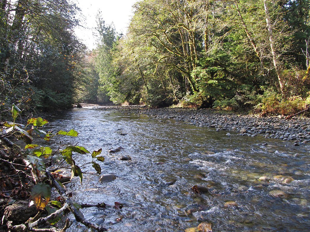
Stamp Falls
British Columbia • 7 m
By Armen Suny · Last verified Jun 2026
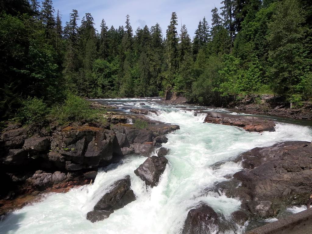
Photo Credits (5)
Difficulty
Easy
Trail Length
1.0 km
Trail Type
Out And Back
Elevation Gain
15 m
About Stamp Falls
Stamp Falls (Stamp River area) is a short-access waterfall and river gorge on northern Vancouver Island. The site features a short maintained trail and viewing platforms over the river, popular for salmon viewing during the fall run and for short walks year-round. Flow and character vary seasonally, higher in spring freshet and lower in late summer. Precise vertical drop measurements vary by source; the site is best known for the river corridor, fish ladders and viewing opportunities rather than a single dramatic high drop.
The Setting
Stamp Falls sits at 50 metres within STAMP RIVER PARK, in the coastal lowlands of British Columbia. The falls drop 7 metres.
Why This Waterfall Exists
Stamp Falls flows over hard volcanic rock laid down about 201-252 million years ago. These resistant rocks form a durable ledge that water cannot easily wear away, creating a 23-foot drop where softer material downstream has already eroded.
Trail & Hike Details
The Approach
The easy 1.0-km out-and-back trail gains 15 metres of elevation on the way to the falls.
Trail Description
A short, well-marked out-and-back route from the parking/day-use area leads to boardwalks and viewing platforms over the river and falls. The trail is mostly flat with only small steps; sections may include boardwalks, packed soil and short stairways. Views are obtained from designated platforms, do not attempt to climb on rocks near the water or off-trail.
What to Expect
The falls drop a gentle 7 metres over hard volcanic rock.
Accessibility
The trail is short and relatively flat, but the surface may be uneven. Contact the managing agency for accessibility details.
Frequently Asked Questions
🐶 Are Dogs Allowed at Stamp Falls?
❌ Dogs are not allowed
Are There Any Fees or Permits Required?
🆖 No fees required
🏊 Is There Swimming at Stamp Falls?
❌ Swimming is not allowed
When to Visit
Late fall (salmon run) for fish viewing and wildlife; spring for higher flows and more dramatic water; summer for easy access and drier trails. Avoid high-flow conditions close to storms if you plan to get close to the river edge.
Seasonal Access
The best time to visit is Spring, Summer, and Fall. Winter access may be limited. Check with the managing park or local authority for current conditions.
Safety Information
Hazards include slippery rock and boardwalk surfaces, strong currents and cold water, variable river flows during spring freshet or after heavy rain, and increased wildlife activity during salmon runs (including bears). Keep to designated trails and platforms, maintain distance from wildlife, supervise children at all times, and exercise caution on wet or icy surfaces. If unsure about conditions, check with BC Parks or local visitor centres before visiting.
Current Water Conditions
1.8 m³/s
Current discharge — how much water is flowing
Much lower than usual for this time of year
Based on 102 years of record
0.59 m
Water depth at gauge
7-Day Discharge Trend
What does this mean for your visit?
Flow is well below normal for this time of year, so the waterfall may be a trickle.
About This Gauge
7-Day Flow Outlook
Based on the WSC gauge SPROAT RIVER NEAR ALBERNI (5 km away).
Today
Barely Flowing
1.8 m³/s
4/10Tomorrow
Barely Flowing
1.8 m³/s
5/10Tue
Barely Flowing
1.7 m³/s
4/10Wed
Barely Flowing
1.6 m³/s
4/10Thu
Barely Flowing
1.6 m³/s
4/10Fri
Barely Flowing
1.5 m³/s
4/10Sat
Barely Flowing
1.6 m³/s
3/10Best window: Tomorrow — barely flowing flow, sunny (trip score 5/10).
Best time of year: this gauge typically runs highest from early November to early February, peaking in December.
How we calculate this
This is a transparent outlook, not a precise forecast. We take the waterfall's current flow strength (how it ranks against its historical normal for today, from the nearest WSC stream gauge), carry that ranking forward along the gauge's seasonal curve, and nudge it for forecast rain. Confidence is highest for the next day or two and falls further out. Always check official conditions and your own judgment before visiting — high flows can be dangerous.
Know when to go.
Get a free email alert when waterfalls near Courtenay hit peak flow. We only send when conditions are worth the trip — no weekly newsletters, no spam.
Weather Forecast
Location & Access
Getting There
Stamp Falls is on Vancouver Island in British Columbia near the Courtenay / Campbell River corridor. The falls are typically reached from the Island Highway (Highway 19) by a short drive to the provincial park day-use area / parking lot and then a short walk to viewing platforms. Exact turnoffs and kilometer markers may vary by map; use a current map or GPS (coordinates provided: 49.3322, -124.9186) and follow signed access to Stamp River / Stamp Falls Provincial Park.
Get Directions on Google MapsParking
There is typically a small parking area/day-use lot at the park/trailhead. Parking may be limited on busy weekends and during salmon runs; use designated spaces only. Expect basic picnic facilities in the day-use area, but confirm current amenities before visiting.
Elevation
50 metres above sea level
Coordinates
49.332240° N, -124.918640° W
Land Management
Managed by Government of British Columbia
Visitor Tips & Gear
• Wear sturdy footwear, surfaces, boardwalks and rock outcrops can be slippery. • Stay on designated trails and viewing platforms; currents are strong and rocks are hazardous. • Bring binoculars during salmon run for wildlife viewing. • Parking may be limited during peak times; arrive early. • Pack out what you bring; follow Leave No Trace. • Cell service may be intermittent; let someone know your plans.
As an Amazon Associate, we earn from qualifying purchases.
For this easy 1.0 km trail, lightweight trail shoes and a water bottle are usually sufficient. Sun exposure on the trail makes good sun protection a must in summer.

Polarized Sunglasses (Knockaround)
Cuts glare off the water so you actually see the falls — and your photos turn out better too.

Columbia Watertight II Rain Jacket
Packs into its own pocket, seam-sealed, and keeps you dry from spray and surprise rain.

Earth Pak Waterproof Dry Bag
Keeps your phone and gear dry when waterfall mist soaks everything else.

Waterproof Phone Pouch (AiRunTech)
Cheap insurance — take photos right next to the falls without killing your phone.

JOBY GorillaPod Starter Kit
Wraps around railings and rocks for long-exposure waterfall shots — no flat surface needed.

Osprey Daylite Daypack
Light, organized, and just the right size for a day hike — fits water, snacks, and layers.
Where to Stay
Browse vacation cabins and private rentals nearby
Unique outdoor stays — tents, yurts, and treehouses
Rent a campervan or RV for your waterfall road trip
Some links are affiliate links. We may earn a commission at no extra cost to you.
Nearby Campground
Stamp River Campground
0.5 km away
Additional Information
Nearby Attractions
Courtenay and the Comox Valley (shops, services), Campbell River (Elk Falls Provincial Park, marina), Miracle Beach Provincial Park and other coastal and river attractions on central Vancouver Island. Distances to nearby towns vary, Courtenay is the closest service centre.
Wildlife
Salmon (seasonal runs), bald eagles, herons, waterfowl, deer and small mammals. Black bears may be present in the general region, take standard bear safety precautions during salmon season and when packing food.
Cities near Stamp Falls
Nearby Waterfalls
Writing about Stamp Falls? Embed this waterfall on your site for free.