Difficulty
Moderate
Trail Length
2.4 miles
Trail Type
Out And Back
Elevation Gain
350 ft
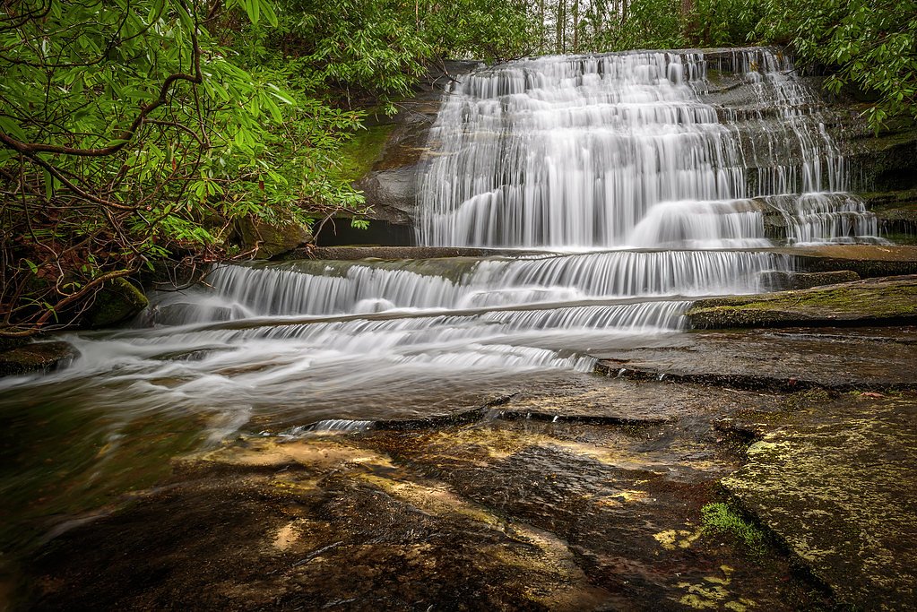
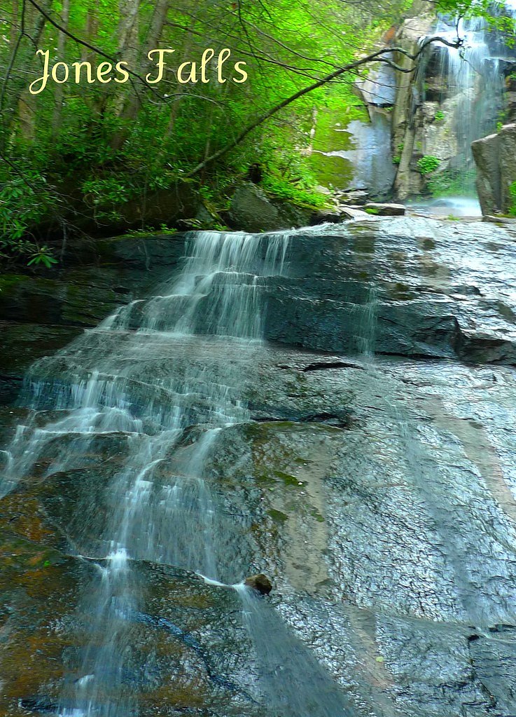
About Watauga Falls
Watauga Falls is a quiet, lesser-known cascade tucked into North Carolina’s forested hills, offering a peaceful setting for hikers and nature lovers who prefer trails off the beaten path. The falls are framed by lush woodland and provide a pleasant destination for a half-day outing; specific measurements of the waterfall’s height aren’t well-documented, which contributes to its tucked-away, exploratory feel. The approach to the falls is a moderate out-and-back hike of about 2.4 miles with roughly 350 feet of elevation gain, making it accessible to most moderately fit hikers and families comfortable with some uphill walking. The nearest developed camping at Watauga Lake Area lies roughly 13.4 km away if you want an overnight base; otherwise plan for a day trip with basic essentials (water, good footwear, and a map) to enjoy the quiet pools and woodland ambiance.
The Setting
Watauga Falls sits at 2,562 feet along the Watauga River, in the hills of North Carolina.
Trail & Hike Details
The Approach
The moderate 2.4-mile out-and-back trail gains 350 feet of elevation on the way to the falls.
Trail Description
Trail length: 2.4 miles (out-and-back); elevation gain: ~350 feet; difficulty: moderate. The route is a relatively short hike that climbs steadily but not steeply, best suited to hikers comfortable with uneven natural tread and typical singletrack or forest paths. Specific USFS trail surface, grade, and class details are not provided in the available data, so expect unpaved, natural-trail conditions and bring appropriate footwear and navigation as needed.
What to Expect
Visitors can expect a peaceful and scenic waterfall surrounded by forested areas. The falls may be less crowded due to their relative obscurity, making it a great spot for solitude and nature photography.
Accessibility
The trail is not wheelchair accessible. Uneven terrain and elevation changes require steady footing.
Frequently Asked Questions
🐶 Are Dogs Allowed at Watauga Falls?
❌ Dogs are not allowed
Are There Any Fees or Permits Required?
🆖 No fees required
🏊 Is There Swimming at Watauga Falls?
❌ Swimming is not allowed
When to Visit
Spring and early summer are ideal for visiting, as the waterfall flow is typically stronger due to seasonal rainfall.
Seasonal Access
The best time to visit is Spring, Summer, and Fall. Winter access may be limited.
Safety Information
The trail may be unmarked and uneven. Visitors should exercise caution, especially after rain, as the area may become slippery. Cell service may be limited, so plan accordingly.
7-Day Flow Outlook
Based on the USGS gauge WATAUGA RIVER NEAR SUGAR GROVE, NC (3 km away).
Today
Moderate
46 cfs
4/10Tomorrow
Moderate
53 cfs
4/10Mon
Moderate
54 cfs
4/10Tue
Moderate
50 cfs
4/10Wed
Moderate
51 cfs
4/10Thu
Moderate
50 cfs
4/10Fri
Moderate
49 cfs
4/10Best window: Today — moderate flow, chance showers and thunderstorms (trip score 4/10).
Best time of year: this gauge typically runs highest from early February to late April, peaking in March.
How we calculate this
This is a transparent outlook, not a precise forecast. We take the waterfall's current flow strength (how it ranks against its historical normal for today, from the nearest USGS stream gauge), carry that ranking forward along the gauge's seasonal curve, and nudge it for forecast rain. Confidence is highest for the next day or two and falls further out. Always check official conditions and your own judgment before visiting — high flows can be dangerous.
Know when to go.
Get a free email alert when waterfalls near Beech Mountain hit peak flow. We only send when conditions are worth the trip — no weekly newsletters, no spam.
Weather Forecast
Location & Access
Getting There
Watauga Falls is located in the Watauga River area of North Carolina. Access may require navigating local roads and potentially unmarked trails. Visitors should consult local maps or guides for precise directions.
Get Directions on Google MapsParking
Parking availability is unclear, but visitors may need to park along nearby roads or at designated trailheads if available.
Elevation
2,562 feet above sea level
Coordinates
36.253181° N, -81.854836° W
Visitor Tips & Gear
Bring a detailed map or GPS device as the trail may not be well-marked. Wear sturdy footwear and be prepared for uneven terrain. Check local conditions before visiting, especially after heavy rains.
As an Amazon Associate, we earn from qualifying purchases.
With 2.4 miles and 350 ft of elevation gain, sturdy boots and trekking poles will help on this moderate trail. Sun exposure on the trail makes good sun protection a must in summer.

Columbia Watertight II Rain Jacket
Packs into its own pocket, seam-sealed, and keeps you dry from spray and surprise rain.

Earth Pak Waterproof Dry Bag
Keeps your phone and gear dry when waterfall mist soaks everything else.

Waterproof Phone Pouch (AiRunTech)
Cheap insurance — take photos right next to the falls without killing your phone.

Timberland Euro Sprint Mid Waterproof
Trusted waterproof boot with premium leather and grippy rubber sole — reliable on rocky, wet trails.

TrailBuddy Trekking Poles
Lightweight aluminum, cork grips, and flip-locks that actually hold — a best-seller for good reason.

Polarized Sunglasses (Knockaround)
Cuts glare off the water so you actually see the falls — and your photos turn out better too.
Where to Stay

Stringer's Peak Retreat

Graystone Lodge, an Ascend Collection Hotel

Hike, Ski & Soak: Beech Mtn Home w/ Views, Hot Tub

Rhode's Motor Lodge
Browse vacation cabins and private rentals nearby
Unique outdoor stays — tents, yurts, and treehouses
Rent a campervan or RV for your waterfall road trip
Some links are affiliate links. We may earn a commission at no extra cost to you.
Nearby Campground
Watauga Lake Area
8.3 miles away · 0 sites
Water recreation is abundant in this area, featuring Watauga Lake; the Doe, Elk and Watauga rivers; several streams and seven waterfalls.Highly developed recreation areas along Watauga Lake provide facilities for fishing, picnicking, swimming and boat launching. The Appalachian National Scenic Trail runs through the area's backcountry. Camp on the lakeshore at Cardens Bluff or in the backcountry along Laurel Fork Creek at Dennis Cove.Watuaga Lake Area MapWatuaga Lake Area Guide
Book on Recreation.govAdditional Information
Nearby Attractions
The Watauga River and nearby hiking trails offer additional opportunities for outdoor recreation.
Wildlife
The area is home to a variety of wildlife, including birds, deer, and small mammals. Be cautious of snakes and other potentially hazardous animals.
Cities near Watauga Falls
Nearby Waterfalls
Other waterfalls named Watauga Falls
1 other waterfall shares this name across the U.S.
Writing about Watauga Falls? Embed this waterfall on your site for free.