Photo Credits (1)
Difficulty
Moderate
Trail Length
2.4 miles
Trail Type
Out And Back
Elevation Gain
350 ft
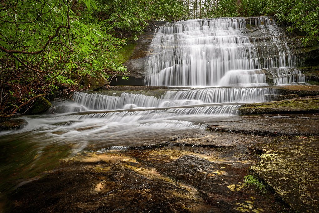
About Dutch Creek Falls
Dutch Creek Falls sits tucked into the rolling foothills of the Blue Ridge Mountains in North Carolina, offering a peaceful cascade framed by mature hardwood forest. The falls are a lovely reward for a relatively short outing — the approach is a pleasant woodland walk that feels much more remote than the mileage suggests. Spring and fall colors make the setting especially photogenic, while the steady, moderate flow of the creek creates a soothing soundtrack for your hike. The trail to the falls is an out-and-back route of about 2.4 miles with roughly 350 feet of elevation gain, so it’s well suited for hikers looking for a moderate, half-day adventure. If you want to extend your visit, Johns River Road Backcountry Camping sits about 6.49 km (approximately 4.0 miles) from the falls, offering nearby primitive camping for overnight trips. Pack sturdy footwear and be prepared for classic Blue Ridge forest conditions to get the most out of this quiet waterfall destination.
The Setting
Dutch Creek Falls sits at 2,930 feet along the Watauga River, in the hills of North Carolina.
Trail & Hike Details
The Approach
The moderate 2.4-mile out-and-back trail gains 350 feet of elevation on the way to the falls.
Trail Description
This is a 2.4-mile out-and-back trail with about 350 feet of elevation gain; the route is rated moderate. The path follows forested terrain and may include uneven tread and short, steeper pitches — expect natural dirt trail with roots and rocks, and potentially muddy sections after rain. No official USFS trail surface/grade/class data is available for this route; navigation is straightforward but typical backcountry precautions (good footwear, water, and a map) are recommended.
What to Expect
Visitors can expect a peaceful hike through wooded areas leading to a picturesque waterfall. The falls are surrounded by lush vegetation, offering a tranquil setting for photography or relaxation.
Accessibility
The trail is not wheelchair accessible. Uneven terrain and elevation changes require steady footing.
Frequently Asked Questions
🐶 Are Dogs Allowed at Dutch Creek Falls?
❌ Dogs are not allowed
Are There Any Fees or Permits Required?
🆖 No fees required
🏊 Is There Swimming at Dutch Creek Falls?
❌ Swimming is not allowed
When to Visit
Spring and early summer are ideal for visiting Dutch Creek Falls, as the water flow is typically stronger during these seasons.
Seasonal Access
The best time to visit is Spring, Summer, and Fall. Winter access may be limited.
Safety Information
The trail may be slippery after rain, and visitors should be cautious near the waterfall due to wet rocks and uneven terrain. Always inform someone of your plans before hiking.
Current Water Conditions
75 ft³/s
Current discharge — how much water is flowing
About average for this time of year
Based on 86 years of record
1.65 ft
Water depth at gauge
7-Day Discharge Trend
What does this mean for your visit?
Flow is about average for this time of year.
About This Gauge
7-Day Flow Outlook
Based on the USGS gauge WATAUGA RIVER NEAR SUGAR GROVE, NC (6 km away).
Today
Strong
81 cfs
10/10Tomorrow
Roaring
86 cfs
6/10Wed
Roaring
92 cfs
6/10Thu
Roaring
91 cfs
6/10Fri
Roaring
90 cfs
6/10Sat
Roaring
91 cfs
6/10Sun
Roaring
87 cfs
6/10Best window: Today — strong flow, mostly sunny (trip score 10/10).
Best time of year: this gauge typically runs highest from early February to late April, peaking in March.
How we calculate this
This is a transparent outlook, not a precise forecast. We take the waterfall's current flow strength (how it ranks against its historical normal for today, from the nearest USGS stream gauge), carry that ranking forward along the gauge's seasonal curve, and nudge it for forecast rain. Confidence is highest for the next day or two and falls further out. Always check official conditions and your own judgment before visiting — high flows can be dangerous.
Know when to go.
Get a free email alert when waterfalls near Valle Crucis hit peak flow. We only send when conditions are worth the trip — no weekly newsletters, no spam.
Weather Forecast
Location & Access
Getting There
Dutch Creek Falls is located near Valle Crucis, North Carolina. Access to the falls typically involves a hike through private property, so visitors should ensure they have permission before attempting to visit.
Get Directions on Google MapsParking
Parking availability is limited and may require parking along nearby roads or designated areas. Visitors should research local guidelines for parking.
Elevation
2,930 feet above sea level
Coordinates
36.188739° N, -81.787610° W
Visitor Tips & Gear
Wear sturdy hiking shoes, as the trail can be uneven or muddy. Check local regulations regarding access, as the trail may cross private property. Bring water and snacks, and avoid visiting after heavy rain due to slippery conditions.
As an Amazon Associate, we earn from qualifying purchases.
With 2.4 miles and 350 ft of elevation gain, sturdy boots and trekking poles will help on this moderate trail. Sun exposure on the trail makes good sun protection a must in summer.

Polarized Sunglasses (Knockaround)
Cuts glare off the water so you actually see the falls — and your photos turn out better too.

Columbia Watertight II Rain Jacket
Packs into its own pocket, seam-sealed, and keeps you dry from spray and surprise rain.

Earth Pak Waterproof Dry Bag
Keeps your phone and gear dry when waterfall mist soaks everything else.

Waterproof Phone Pouch (AiRunTech)
Cheap insurance — take photos right next to the falls without killing your phone.

Timberland Euro Sprint Mid Waterproof
Trusted waterproof boot with premium leather and grippy rubber sole — reliable on rocky, wet trails.

TrailBuddy Trekking Poles
Lightweight aluminum, cork grips, and flip-locks that actually hold — a best-seller for good reason.
Where to Stay

Stringer's Peak Retreat

Graystone Lodge, an Ascend Collection Hotel

Taylor House Inn

Hike, Ski & Soak: Beech Mtn Home w/ Views, Hot Tub
Browse vacation cabins and private rentals nearby
Unique outdoor stays — tents, yurts, and treehouses
Rent a campervan or RV for your waterfall road trip
Some links are affiliate links. We may earn a commission at no extra cost to you.
Nearby Campground
Johns River Road Backcountry Camping
4 miles away · 2 sites
Overview Old John’s River Road Backcountry Camping is a primitive camping location along the Mountains to Sea Trail near Blowing Rock, North Carolina. There are 2 sites available, each with a fire ring. Maximum capacity is 6 people per site and the maximum stay length is 3 nights. Access this location either by hiking the Boone Fork Trail from the Julian Price Park Picnic Area, or Old John’s River Road between mile 296 and 297 on the Blue Ridge Parkway. Black bears and other wildlife frequent thi
Book on Recreation.govAdditional Information
Nearby Attractions
Valle Crucis Community Park, Blue Ridge Parkway, and Grandfather Mountain are nearby attractions worth visiting.
Wildlife
The area is home to various wildlife, including birds, deer, and small mammals. Be cautious of snakes and other potentially hazardous animals.
Cities near Dutch Creek Falls
Nearby Waterfalls
Writing about Dutch Creek Falls? Embed this waterfall on your site for free.