Photo Credits (3)
Difficulty
Moderate
Trail Length
1.5 miles
Trail Type
Out And Back
Elevation Gain
400 ft
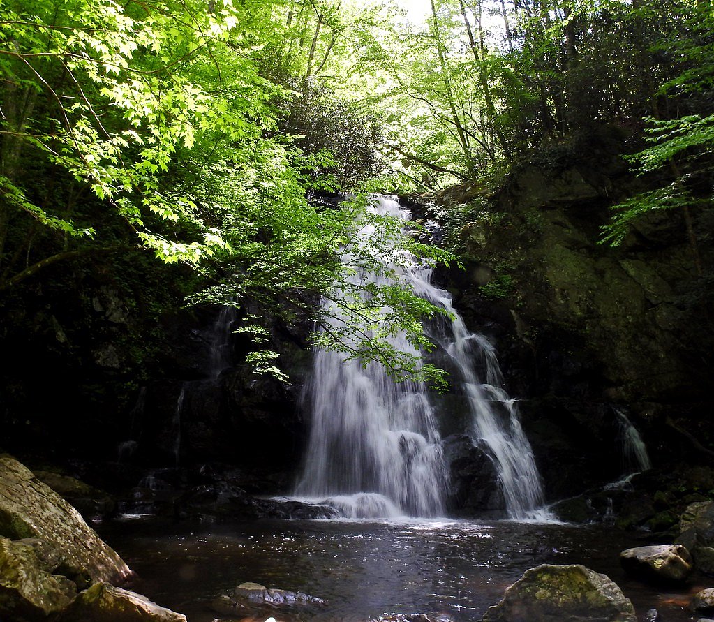
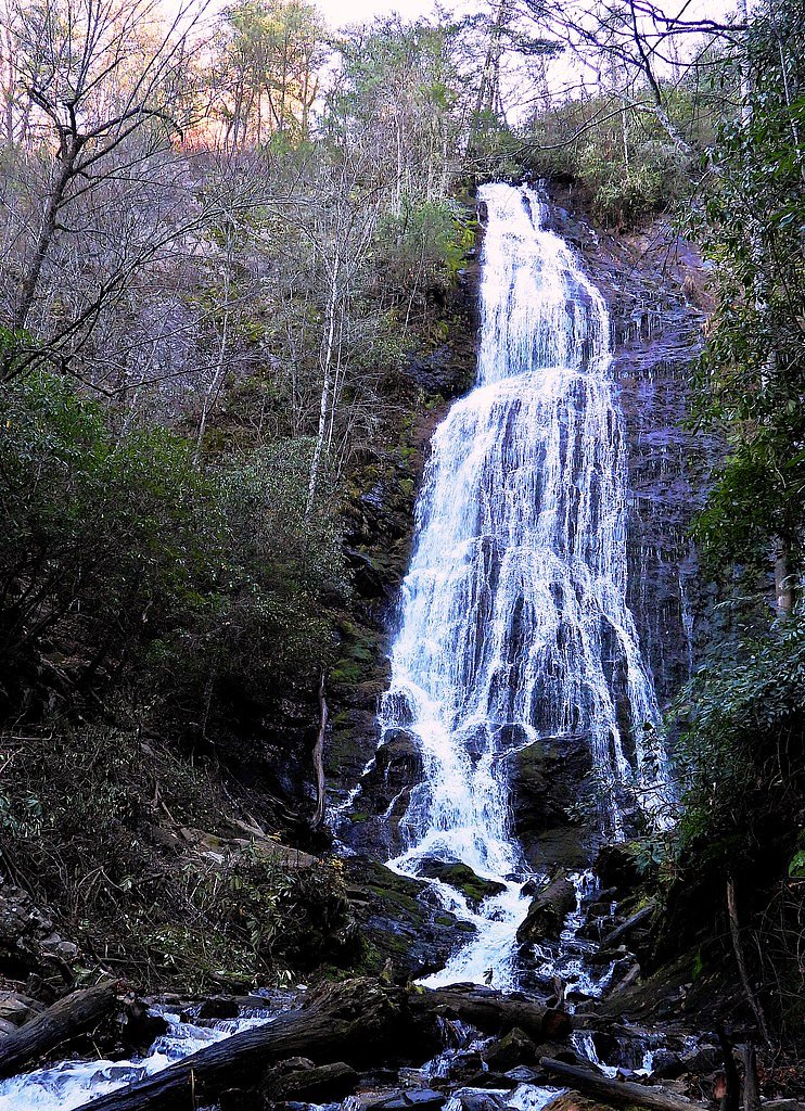
About Twisting Falls
Twisting Falls, also known as Compression Falls, is a stunning waterfall located in the Cherokee National Forest in Tennessee. It features a dramatic cascade into a deep pool, making it a popular spot for adventurous visitors.
The Setting
Twisting Falls sits at 2,372 feet within Cherokee National Forest, in the hills of Tennessee.
Trail & Hike Details
The Approach
The moderate 1.5-mile out-and-back trail gains 400 feet of elevation on the way to the falls.
Trail Description
The trail to Twisting Falls is relatively short but steep in sections, with uneven terrain and some slippery areas, especially after rain. The descent to the falls requires caution, as the path can be narrow and rocky.
What to Expect
Swimming is permitted. Dogs are welcome.
Accessibility
The trail is not wheelchair accessible. Uneven terrain and elevation changes require steady footing.
Frequently Asked Questions
🐶 Are Dogs Allowed at Twisting Falls?
✅ Dogs are allowed
Are There Any Fees or Permits Required?
🆖 No fees required
🏊 Is There Swimming at Twisting Falls?
✅ Swimming is allowed
When to Visit
Spring and summer are the best times to visit for lush greenery and warmer weather, but fall offers beautiful foliage. Winter visits may be more challenging due to icy conditions.
Seasonal Access
The best time to visit is Spring, Summer, and Fall. Winter access may be limited. Check with Cherokee National Forest for seasonal road closures.
Safety Information
The trail can be hazardous, especially after rain. Watch for slippery rocks and steep drop-offs. Swimming in the pool can be dangerous due to strong currents and submerged rocks. Always exercise caution and avoid risky behavior.
Know when to go.
Get a free email alert when waterfalls near Elk Park hit peak flow. We only send when conditions are worth the trip — no weekly newsletters, no spam.
Weather Forecast
Location & Access
Getting There
Twisting Falls is located near the town of Elk Mills, Tennessee. Access is via a trailhead off Poga Road. The trailhead is unmarked, so visitors should use GPS coordinates or detailed directions to locate it.
Get Directions on Google MapsParking
Parking is available in a small, unpaved lot near the trailhead. Space is limited, so arriving early is recommended.
Elevation
2,372 feet above sea level
Coordinates
36.229845° N, -81.975117° W
Land Management
Managed by USFS
Visitor Tips & Gear
Wear sturdy hiking shoes with good grip, as the trail can be slippery. Bring plenty of water and snacks, and avoid visiting after heavy rain due to potential trail hazards. Cell service may be limited in the area.
As an Amazon Associate, we earn from qualifying purchases.
With 1.5 miles and 400 ft of elevation gain, sturdy boots and trekking poles will help on this moderate trail. Sun exposure on the trail makes good sun protection a must in summer.

Polarized Sunglasses (Knockaround)
Cuts glare off the water so you actually see the falls — and your photos turn out better too.

Columbia Watertight II Rain Jacket
Packs into its own pocket, seam-sealed, and keeps you dry from spray and surprise rain.

Earth Pak Waterproof Dry Bag
Keeps your phone and gear dry when waterfall mist soaks everything else.

Waterproof Phone Pouch (AiRunTech)
Cheap insurance — take photos right next to the falls without killing your phone.

Timberland Euro Sprint Mid Waterproof
Trusted waterproof boot with premium leather and grippy rubber sole — reliable on rocky, wet trails.

TrailBuddy Trekking Poles
Lightweight aluminum, cork grips, and flip-locks that actually hold — a best-seller for good reason.
Where to Stay

Stringer's Peak Retreat

Hike, Ski & Soak: Beech Mtn Home w/ Views, Hot Tub

Graystone Lodge, an Ascend Collection Hotel

Paws at the Peak
Browse vacation cabins and private rentals nearby
Unique outdoor stays — tents, yurts, and treehouses
Rent a campervan or RV for your waterfall road trip
Some links are affiliate links. We may earn a commission at no extra cost to you.
Nearby Campground
Watauga Lake Area
6.3 miles away · 0 sites
Water recreation is abundant in this area, featuring Watauga Lake; the Doe, Elk and Watauga rivers; several streams and seven waterfalls.Highly developed recreation areas along Watauga Lake provide facilities for fishing, picnicking, swimming and boat launching. The Appalachian National Scenic Trail runs through the area's backcountry. Camp on the lakeshore at Cardens Bluff or in the backcountry along Laurel Fork Creek at Dennis Cove.Watuaga Lake Area MapWatuaga Lake Area Guide
Book on Recreation.govNearby Hot Springs
Hot springs near Elk Park, Tennessee

Looking for a soak after your hike? Explore more hot springs near Elk Park, Tennessee on SoakingSprings.
Explore Tennessee springsAdditional Information
Nearby Attractions
Watauga Lake, Laurel Falls, and the Appalachian Trail are nearby attractions worth exploring.
Wildlife
The area is home to various wildlife, including deer, birds, and small mammals. Be cautious of snakes, especially in warmer months.
Cities near Twisting Falls
Nearby Waterfalls
Writing about Twisting Falls? Embed this waterfall on your site for free.