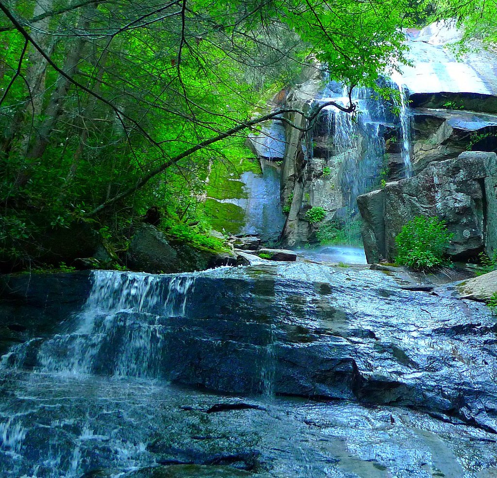
Jones Falls
By Armen Suny · Last verified May 2026
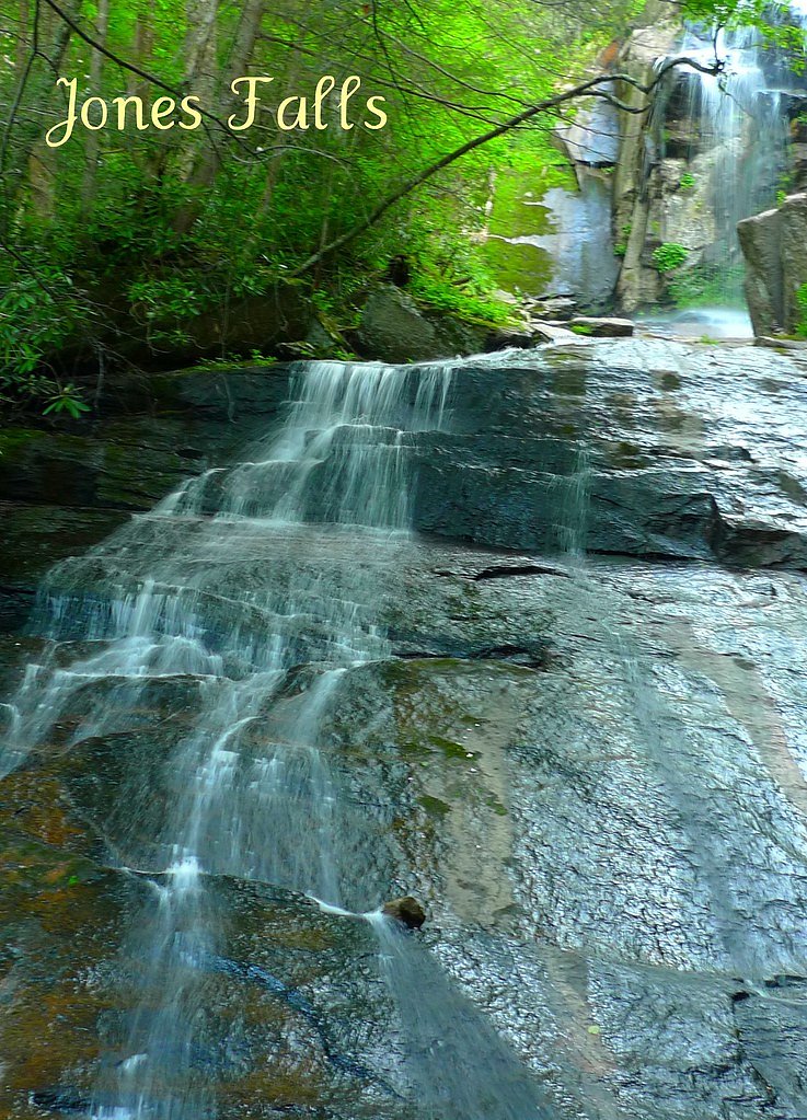

Photo Credits (2)
Difficulty
Moderate
Trail Length
3.0 miles
Trail Type
Out And Back
Elevation Gain
300 ft
About Jones Falls
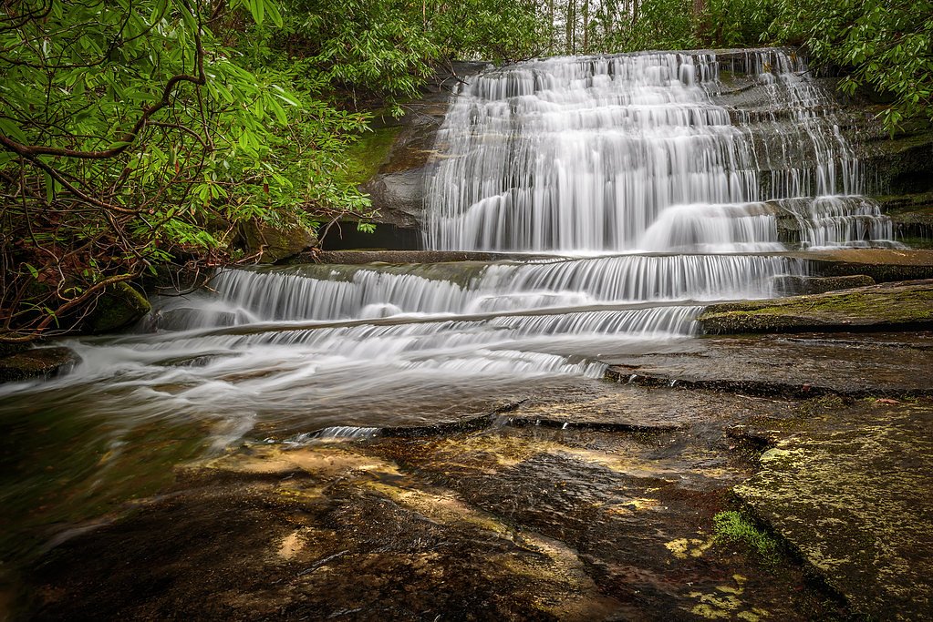
Jones Falls is a picturesque cascade tucked near the Tennessee–North Carolina border, nestled within the Cherokee National Forest and managed by the U.S. Forest Service. The falls sit along the Appalachian Trail corridor, and the route is formally mapped as ANST - APPALACHIAN RD (Trail #TR1-08). Framed by lush hardwood forest, the falls offer a peaceful spot to pause and enjoy the tumbling water and woodland quiet — a favorite quick detour for thru-hikers and day visitors alike. Access to Jones Falls is an inviting moderate hike that rewards a short effort with scenic forest and creekside views. The official USFS route to the falls is an out-and-back of about 3.0 miles with roughly 300 feet of elevation gain; the tread is native material and rated Class 3 on the USFS trail classification, so expect a few steeper or more rugged sections where steady footing and basic scrambling may be needed.
The Setting
Jones Falls sits at 3,182 feet within Cherokee National Forest, fed by the Watauga River, in the mountains of Tennessee.
Trail & Hike Details
The Approach
The moderate hike follows Anst Appalachian Rd (#TR1-08), a 3.0-mile out-and-back trail over natural surface. Expect 300 feet of elevation gain. The trail is developed (Class 3).
USFS Trail
ANST - APPALACHIAN RD #TR1-08
Trail Class
Developed
Surface
USFS Segment
159.75 miTrail Description
USFS route: ANST - APPALACHIAN RD (Trail #TR1-08). Trail type: out-and-back, approximately 3.0 miles round trip with about 300 ft elevation gain. Surface: native material. USFS class: 3. Difficulty: moderate. The tread follows the Appalachian Trail corridor through wooded terrain; sections can be uneven and include short steep or rocky approaches on the final descent to the falls, so wear sturdy shoes and be prepared for basic scrambling.
What to Expect
Dogs are welcome.
Accessibility
The trail is not wheelchair accessible. Uneven terrain and elevation changes require steady footing.
Frequently Asked Questions
🐶 Are Dogs Allowed at Jones Falls?
✅ Dogs are allowed
Are There Any Fees or Permits Required?
🆖 No fees required
🏊 Is There Swimming at Jones Falls?
❌ Swimming is not allowed
When to Visit
Spring and early summer are the best times to visit, as the waterfall flow is strongest due to seasonal rainfall. Fall offers beautiful foliage, while winter may provide a quieter experience but could have icy conditions.
Seasonal Access
The best time to visit is Spring, Summer, and Fall. Winter access may be limited. Check with Cherokee National Forest for seasonal road closures.
Safety Information
Exercise caution near the waterfall, as rocks can be slippery. Avoid visiting during heavy rain or icy conditions. Cell service may be limited in the area, so plan accordingly.
Current Water Conditions
Based on a USGS gauge 17.1 miles away
1,580 ft³/s
Current discharge — how much water is flowing
Higher than usual for this time of year
Based on 9 years of record
4.56 ft
Water depth at gauge
7-Day Discharge Trend
What does this mean for your visit?
The water is flowing higher than usual for this time of year.
About This Gauge
This gauge is on a regional waterway. Conditions at the falls may differ, especially after local rain.
7-Day Flow Outlook
Based on the USGS gauge WATAUGA RIVER AT ELIZABETHTON, TN (28 km away).
Today
Strong
1801 cfs
7/10Tomorrow
Strong
2020 cfs
7/10Tue
Strong
1726 cfs
7/10Wed
Strong
2110 cfs
7/10Thu
Strong
1926 cfs
7/10Fri
Strong
1801 cfs
7/10Sat
Strong
1962 cfs
7/10Best window: Today — strong flow, mostly sunny then slight chance showers and thunderstorms (trip score 7/10).
Best time of year: this gauge typically runs highest from mid February to mid March, peaking in May.
How we calculate this
This is a transparent outlook, not a precise forecast. We take the waterfall's current flow strength (how it ranks against its historical normal for today, from the nearest USGS stream gauge), carry that ranking forward along the gauge's seasonal curve, and nudge it for forecast rain. Confidence is highest for the next day or two and falls further out. Always check official conditions and your own judgment before visiting — high flows can be dangerous.
Know when to go.
Get a free email alert when waterfalls near Elk Park hit peak flow. We only send when conditions are worth the trip — no weekly newsletters, no spam.
Weather Forecast
Location & Access
Getting There
Jones Falls can be accessed via the Appalachian Trail. The most common starting point is from the Elk River Falls trailhead in North Carolina, which requires a hike of approximately 3 miles to reach the falls. The trail crosses into Tennessee and is well-marked.
Get Directions on Google MapsParking
Parking is available at the Elk River Falls trailhead in North Carolina. The parking area is free but may be limited during peak seasons.
Elevation
3,182 feet above sea level
Coordinates
36.202901° N, -81.982340° W
Land Management
Managed by USFS
Visitor Tips & Gear
Wear sturdy hiking shoes as the trail can be rocky and slippery, especially near the falls. Bring plenty of water and snacks, as there are no facilities along the trail. Check weather conditions before your visit, as heavy rain can make the trail muddy and more challenging.
As an Amazon Associate, we earn from qualifying purchases.
With 3.0 miles and 300 ft of elevation gain, sturdy boots and trekking poles will help on this moderate trail. Sun exposure on the trail makes good sun protection a must in summer.

Polarized Sunglasses (Knockaround)
Cuts glare off the water so you actually see the falls — and your photos turn out better too.

Columbia Watertight II Rain Jacket
Packs into its own pocket, seam-sealed, and keeps you dry from spray and surprise rain.

Earth Pak Waterproof Dry Bag
Keeps your phone and gear dry when waterfall mist soaks everything else.

Waterproof Phone Pouch (AiRunTech)
Cheap insurance — take photos right next to the falls without killing your phone.

Timberland Euro Sprint Mid Waterproof
Trusted waterproof boot with premium leather and grippy rubber sole — reliable on rocky, wet trails.

TrailBuddy Trekking Poles
Lightweight aluminum, cork grips, and flip-locks that actually hold — a best-seller for good reason.
Where to Stay

Stringer's Peak Retreat

Hike, Ski & Soak: Beech Mtn Home w/ Views, Hot Tub

Graystone Lodge, an Ascend Collection Hotel

Paws at the Peak
Browse vacation cabins and private rentals nearby
Unique outdoor stays — tents, yurts, and treehouses
Rent a campervan or RV for your waterfall road trip
Some links are affiliate links. We may earn a commission at no extra cost to you.
Nearby Campground
DENNIS COVE CAMPGROUND
8.1 miles away · 14 sites
Overview Dennis Cove Campground is a secluded campground along Laurel Fork Creek at an elevation of 2,650 feet in Carter County. This remote developed campground is popular with those seeking a rustic experience. The altitude, creek side location and lush forest surroundings make Dennis Cove particularly desirable during hot summer months. With 15 campsites, Dennis Cove is a great option for family camping. Recreation Along with camping, Laurel Fork Creek is stocked with rainbow trout below the
Book on Recreation.govNearby Hot Springs
Hot springs near Elk Park, Tennessee

Looking for a soak after your hike? Explore more hot springs near Elk Park, Tennessee on SoakingSprings.
Explore Tennessee springsAdditional Information
Nearby Attractions
Elk River Falls, Appalachian Trail, Roan Mountain State Park
Wildlife
The area is home to a variety of wildlife, including deer, birds, and small mammals. Be cautious of snakes during warmer months.
Cities near Jones Falls
Nearby Waterfalls
Other waterfalls named Jones Falls
1 other waterfall shares this name across the U.S.
Writing about Jones Falls? Embed this waterfall on your site for free.