Lower Canyon Falls
By Armen Suny · Last verified Mar 2026

Photo Credits (5)
Difficulty
Moderate
Trail Length
2.4 miles
Trail Type
Out And Back
Elevation Gain
350 ft
About Lower Canyon Falls
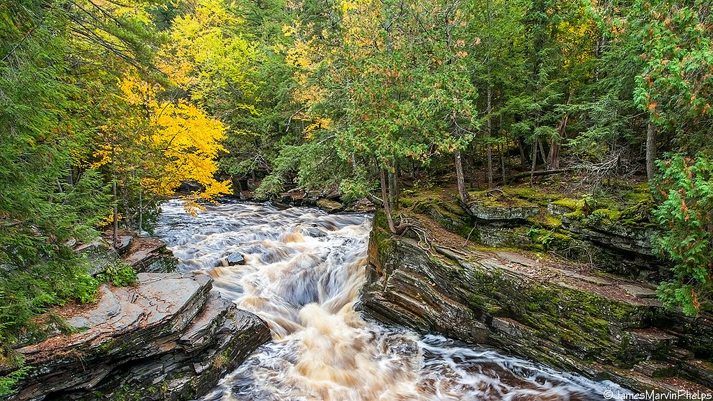
Lower Canyon Falls tumbles along the Sturgeon River in Michigan’s Upper Peninsula, sitting within the rugged Canyon Falls and Gorge area. The waterfall and surrounding rim are located on State Forest lands designated PCON and managed by OTHS, which helps preserve the gorge’s dramatic rock walls and river-cut scenery. Hikers come here for the sense of wilderness and the powerful river views rather than developed amenities. Access is via a short but rewarding hike that threads along the Sturgeon River and the gorge rim, offering sweeping views of the water and forested cliffs. The route is an out-and-back that gains about 350 feet over its length and is rated moderate—ideal for visitors who are comfortable with steady uphill sections and uneven trail underfoot. Pack sturdy shoes and a camera: the canyon scenery makes for memorable photos and a classic Upper Peninsula outing.
The Setting
Lower Canyon Falls sits at 1,332 feet within State Forest, fed by the Sturgeon River, in the foothills of Michigan.
Trail & Hike Details
The Approach
The moderate 2.4-mile out-and-back trail gains 350 feet of elevation on the way to the falls.
Trail Description
This is an out-and-back route of 2.4 miles with approximately 350 feet of elevation gain and is rated moderate. The trail follows the Sturgeon River and the rim of the Canyon Falls gorge, delivering river and cliff-side views; expect steady uphill and downhill sections rather than a flat stroll. Trail surface and formal USFS trail class/number are not specified in the available land manager information; the path is best negotiated with hiking footwear and a moderate level of fitness.
What to Expect
Dogs are welcome.
Accessibility
The trail is not wheelchair accessible. Uneven terrain and elevation changes require steady footing.
Frequently Asked Questions
🐶 Are Dogs Allowed at Lower Canyon Falls?
✅ Dogs are allowed
Are There Any Fees or Permits Required?
🆖 No fees required
🏊 Is There Swimming at Lower Canyon Falls?
❌ Swimming is not allowed
When to Visit
Spring and early summer are ideal for viewing the waterfall at its fullest flow, but the area is beautiful throughout the year.
Seasonal Access
The best time to visit is Spring, Summer, and Fall. Winter access may be limited.
Safety Information
Exercise caution near the edge of the gorge and around the waterfall, as rocks can be slippery. Be aware of changing weather conditions, especially in winter when ice may form on the trail.
Current Water Conditions
88 ft³/s
Current discharge — how much water is flowing
About average for this time of year
Based on 86 years of record
4.09 ft
Water depth at gauge
7-Day Discharge Trend
What does this mean for your visit?
Flow is about average for this time of year.
About This Gauge
This gauge is on a nearby waterway and may not reflect exact conditions at the falls.
7-Day Flow Outlook
Based on the USGS gauge STURGEON RIVER NEAR SIDNAW, MI (9 km away).
Today
Low
100 cfs
3/10Tomorrow
Low
120 cfs
3/10Wed
Low
110 cfs
3/10Thu
Low
106 cfs
3/10Fri
Low
103 cfs
3/10Sat
Low
90 cfs
4/10Sun
Low
78 cfs
4/10Best window: Sat — low flow, chance rain showers (trip score 4/10).
Best time of year: this gauge typically runs highest from late March to early June, peaking in April.
How we calculate this
This is a transparent outlook, not a precise forecast. We take the waterfall's current flow strength (how it ranks against its historical normal for today, from the nearest USGS stream gauge), carry that ranking forward along the gauge's seasonal curve, and nudge it for forecast rain. Confidence is highest for the next day or two and falls further out. Always check official conditions and your own judgment before visiting — high flows can be dangerous.
Know when to go.
Get a free email alert when waterfalls near Covington hit peak flow. We only send when conditions are worth the trip — no weekly newsletters, no spam.
Weather Forecast
Location & Access
Getting There
Lower Canyon Falls is located off US-41 near L'Anse, Michigan. The trailhead for the Canyon Falls and Gorge is accessible from a parking area at a roadside rest stop.
Get Directions on Google MapsParking
There is a parking area at the trailhead, which is free and typically has ample space.
Elevation
1,332 feet above sea level
Coordinates
46.622400° N, -88.477283° W
Land Management
Managed by OTHS
Visitor Tips & Gear
Wear sturdy shoes as the trail can be muddy or slippery, especially after rain. Bring insect repellent during the summer months to protect against mosquitoes.
As an Amazon Associate, we earn from qualifying purchases.
With 2.4 miles and 350 ft of elevation gain, sturdy boots and trekking poles will help on this moderate trail. Sun exposure on the trail makes good sun protection a must in summer.

Polarized Sunglasses (Knockaround)
Cuts glare off the water so you actually see the falls — and your photos turn out better too.

Columbia Watertight II Rain Jacket
Packs into its own pocket, seam-sealed, and keeps you dry from spray and surprise rain.

Earth Pak Waterproof Dry Bag
Keeps your phone and gear dry when waterfall mist soaks everything else.

Waterproof Phone Pouch (AiRunTech)
Cheap insurance — take photos right next to the falls without killing your phone.

Timberland Euro Sprint Mid Waterproof
Trusted waterproof boot with premium leather and grippy rubber sole — reliable on rocky, wet trails.

TrailBuddy Trekking Poles
Lightweight aluminum, cork grips, and flip-locks that actually hold — a best-seller for good reason.
Where to Stay

Champion Vacation Rental with Fire Pit!

UP Escape in the Pines

Whole home, private lake, sauna, WFH office

Tiny Woodland Cottage Retreat with Yard in Pelkie
Browse vacation cabins and private rentals nearby
Unique outdoor stays — tents, yurts, and treehouses
Rent a campervan or RV for your waterfall road trip
Some links are affiliate links. We may earn a commission at no extra cost to you.
Nearby Campground
Sturgeon River Gorge Wilderness
10.5 miles away · 0 sites
The Wild and Scenic Sturgeon River rushes out of the northern portion of this wilderness, over the 20 foot volcanic outcroppings of Sturgeon Falls, and through a gorge that reaches 350 feet in depth and a mile in width. Throughout this rugged, steep Wilderness, the Sturgeon and Little Silver Rivers and their tributaries have carved falls, rapids, ponds, oxbows, and terraces. Stunning views are possible from the eastern rim of the gorge. Except for a few naturally bare slopes, most of the land is
Book on Recreation.govAdditional Information
Nearby Attractions
The nearby town of L'Anse offers dining and lodging options. The Upper Peninsula is also home to other waterfalls and scenic areas, such as Tahquamenon Falls and Pictured Rocks National Lakeshore.
Wildlife
The area is home to a variety of wildlife, including deer, birds, and small mammals. Be cautious of ticks during warmer months.
Cities near Lower Canyon Falls
Nearby Waterfalls

Writing about Lower Canyon Falls? Embed this waterfall on your site for free.