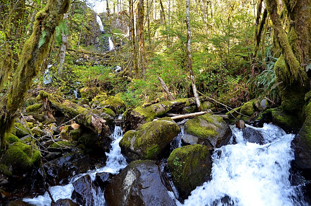
Stout Creek Falls
Oregon • 34 ft
By Armen Suny · Last verified May 2026
Difficulty
Moderate
Trail Length
2.4 miles
Trail Type
Out And Back
Elevation Gain
350 ft
About Stout Creek Falls
Stout Creek Falls is a quiet, 34-foot cascade tucked into Marion County, Oregon, that drops into a small, fern-fringed pool—an ideal spot for hikers seeking a peaceful nature break. The setting feels secluded but approachable, with mossy boulders and mixed conifer forest framing the falls. The land is managed by SDNR under the Forest Development Fund (Board of Forestry), designated as an SRMA and overseen by SLB, so visitors should expect a managed-forest experience rather than a wilderness setting. The falls sit in a waterfall-rich part of the western Cascade foothills; nearby Ayers Falls—on Ayers Creek, the smallest tributary of Stout Creek—lies on the outer edge of Santiam State Forest near Mehama, where the Mount Hood National Forest foothills meet the Middle Santiam Wilderness. That concentration of streams and steep terrain means Stout Creek Falls is one of several rewarding short hikes in the region, making it a pleasant stop on a broader exploration of Marion County’s waterfalls.
The Setting
Stout Creek Falls sits at 1,699 feet within Forest Development Fund (Board Of Forestry), fed by the Little North Santiam River, in the hills of Oregon. The falls drop 34 feet.
Height: 34 feet
Trail & Hike Details
The Approach
The moderate 2.4-mile out-and-back trail gains 350 feet of elevation on the way to the falls.
Trail Description
The out-and-back route to Stout Creek Falls is about 2.4 miles round trip with roughly 350 feet of elevation gain, typically rated moderate. The trail threads through mixed forest and can have uneven or muddy sections—wet-season footwear and steady footing are recommended. Trail users should expect a moderate climb rather than steep technical sections; the path leads directly to the falls and the small pool at its base. (Waterfall height: 34 feet.)
What to Expect
The falls drop 34 feet. Dogs are welcome.
Accessibility
The trail is not wheelchair accessible. Uneven terrain and elevation changes require steady footing.
Frequently Asked Questions
🐶 Are Dogs Allowed at Stout Creek Falls?
✅ Dogs are allowed
Are There Any Fees or Permits Required?
🆖 No fees required
🏊 Is There Swimming at Stout Creek Falls?
❌ Swimming is not allowed
When to Visit
Spring and early summer are ideal times to visit, as the waterfall flow is strongest due to seasonal rains and snowmelt. Fall offers beautiful foliage, while winter may bring icy conditions.
Seasonal Access
The best time to visit is Spring, Summer, and Fall. Winter access may be limited.
Safety Information
The trail can be slippery, especially during wet conditions. Exercise caution near the waterfall edge, as rocks may be unstable. Cell service is limited, so inform someone of your plans before visiting.
Current Water Conditions
143 ft³/s
Current discharge — how much water is flowing
About average for this time of year
Based on 94 years of record
3.14 ft
Water depth at gauge
62°F
CoolRefreshing for swimming
7-Day Discharge Trend
What does this mean for your visit?
Flow is about average for this time of year. Water temperature is a refreshing 62 degrees F, good for a quick swim. Expect excellent dissolved oxygen levels. PH is normal at 7.8 and mineral content is typical.
Water Quality
Dissolved Oxygen
ExcellentSupports aquatic life
pH
NormalWithin healthy range (6.5-8.5)
Conductance
Dissolved minerals in the water
About This Gauge
7-Day Flow Outlook
Based on the USGS gauge LITTLE NORTH SANTIAM RIVER NEAR MEHAMA, OR (3 km away).
Today
Roaring
161 cfs
6/10Tomorrow
Roaring
155 cfs
6/10Mon
Roaring
145 cfs
6/10Tue
Roaring
127 cfs
8/10Wed
Roaring
114 cfs
8/10Thu
Roaring
120 cfs
6/10Fri
Roaring
121 cfs
6/10Best window: Tue — roaring flow, patchy fog (trip score 8/10).
Best time of year: this gauge typically runs highest from early January to late January, peaking in January.
How we calculate this
This is a transparent outlook, not a precise forecast. We take the waterfall's current flow strength (how it ranks against its historical normal for today, from the nearest USGS stream gauge), carry that ranking forward along the gauge's seasonal curve, and nudge it for forecast rain. Confidence is highest for the next day or two and falls further out. Always check official conditions and your own judgment before visiting — high flows can be dangerous.
Know when to go.
Get a free email alert when waterfalls near Lyons hit peak flow. We only send when conditions are worth the trip — no weekly newsletters, no spam.
Weather Forecast
Location & Access
Getting There
Stout Creek Falls is located near Mehama, Oregon. Access typically involves driving on gravel roads and a short hike to reach the falls. The trailhead is not well-marked, so using GPS coordinates or detailed directions is recommended.
Get Directions on Google MapsParking
Parking is limited and located along the side of the road near the trailhead. Visitors should ensure they do not block access roads or private property.
Elevation
1,699 feet above sea level
Coordinates
44.813889° N, -122.573889° W
Land Management
Managed by SLB
Visitor Tips & Gear
Bring sturdy shoes, especially during the rainy season, as the trail can be muddy. Consider visiting early in the day to avoid any potential crowds and to enjoy the peaceful surroundings. Cell service may be limited in the area, so plan accordingly.
As an Amazon Associate, we earn from qualifying purchases.
With 2.4 miles and 350 ft of elevation gain, sturdy boots and trekking poles will help on this moderate trail. Sun exposure on the trail makes good sun protection a must in summer.

Columbia Watertight II Rain Jacket
Packs into its own pocket, seam-sealed, and keeps you dry from spray and surprise rain.

Earth Pak Waterproof Dry Bag
Keeps your phone and gear dry when waterfall mist soaks everything else.

Waterproof Phone Pouch (AiRunTech)
Cheap insurance — take photos right next to the falls without killing your phone.

Timberland Euro Sprint Mid Waterproof
Trusted waterproof boot with premium leather and grippy rubber sole — reliable on rocky, wet trails.

TrailBuddy Trekking Poles
Lightweight aluminum, cork grips, and flip-locks that actually hold — a best-seller for good reason.

Polarized Sunglasses (Knockaround)
Cuts glare off the water so you actually see the falls — and your photos turn out better too.
Where to Stay

The 1908 Bungalow

Oregon Garden Resort

La Quinta by Wyndham Salem OR

Howard Johnson by Wyndham Salem
Browse vacation cabins and private rentals nearby
Unique outdoor stays — tents, yurts, and treehouses
Rent a campervan or RV for your waterfall road trip
Some links are affiliate links. We may earn a commission at no extra cost to you.
Nearby Campground
Aquila Vista Recreation Site
12.4 miles away · 1 sites
Overview Aquila Vista is closed until further notice to remove wildfire burned danger trees. Aquila Vista is available for overnight group camping for groups up to 30 people and 20 vehicles. The season, when it reopens, will be mid-May through mid-October. The site is located in the heart of the forest next to a large beaver pond. There is plenty of hiking and natural beauty to see at Aquila Vista including a small waterfall. Amenities include vault toilet, two group picnic shelters with multiple
Book on Recreation.govNearby Hot Springs
Hot springs near Lyons, Oregon

Bagby Hot Springs
Bagby Hot Springs flows at 136°F deep in Mount Hood National Forest at 2,272 feet elevation, requiring a 3,720-foot hike from F...

Breitenbush Hot Springs
Breitenbush Hot Springs emerges at 198°F along the Breitenbush River, ranking as one of Oregon's hottest thermal features with ...

Austin Hot Springs
Austin Hot Springs discharges at 186°F along the Clackamas River at 1,680 feet elevation, emerging just 310 feet from Clackamas...

Bigelow Hot Springs
Bigelow Hot Springs, also called Deer Creek Hot Springs, emerges at 142°F just 400 feet from Deer Creek Road in the Willamette ...
Foley Springs
Foley Springs emerges at 178°F in the Cascade Range of Lane County, making it one of Oregon's hottest thermal features with rec...
Belknap Springs
Belknap Springs flows at 160°F along the McKenzie River in the Cascade Range, emerging just 510 feet from North Belknap Springs...
Looking for a soak after your hike? Explore more hot springs near Lyons, Oregon on SoakingSprings.
Explore Oregon springsAdditional Information
Nearby Attractions
Nearby attractions include Silver Falls State Park and Opal Creek Wilderness, both offering additional hiking and waterfall experiences.
Wildlife
The area is home to various bird species, deer, and other small forest animals. Visitors may also encounter native plants and fungi.
Cities near Stout Creek Falls
Nearby Waterfalls


Writing about Stout Creek Falls? Embed this waterfall on your site for free.