Photo Credits (3)
Difficulty
Easy
Trail Length
1.0 miles
Trail Type
Out And Back
Elevation Gain
100 ft
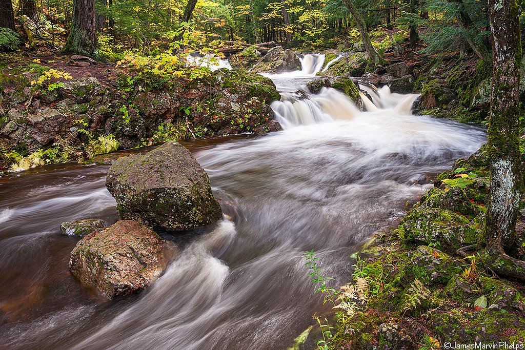
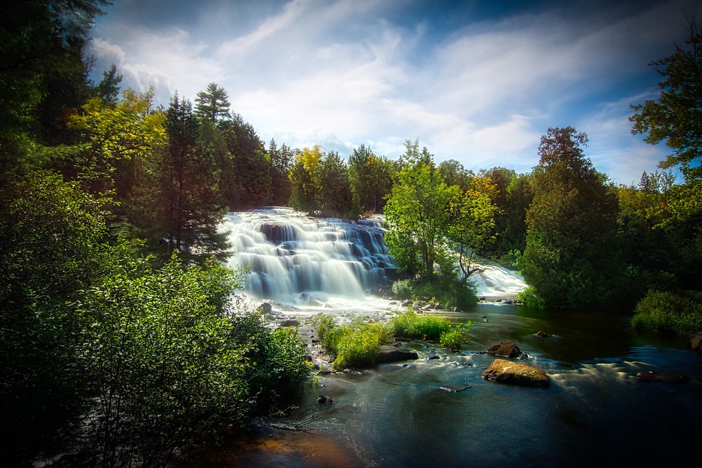
About Rock Bluff Falls
Rock Bluff Falls is a small, peaceful cascade tucked into the wooded hills of Michigan’s Upper Peninsula, surrounded by the mixed hardwoods of the Ottawa National Forest. Managed by the U.S. Forest Service, the site rewards a short stroll with a scenic view of water tumbling over a rocky bluff — an ideal spot for photographers and families seeking a quiet forest outing. Access is provided by a USFS-maintained spur (NFST-T06031031 / Trail #T06031031), so you’ll be following a route managed and signed by the Forest Service as you approach the falls. The approach is short and easy, making Rock Bluff Falls a great half-day stop on a UP trip. The overall route is an out-and-back of about 1.0 mile round trip with roughly 100 feet of elevation gain; the USFS segment to the falls itself is very short, so most visitors can enjoy the setting without strenuous hiking. Come prepared for potentially muddy footing after rain and expect a tranquil, wooded experience rather than a heavily developed attraction.
The Setting
Rock Bluff Falls sits at 1,362 feet within Ottawa National Forest, fed by the Middle Branch Ontonagon River, in the foothills of Michigan.
Trail & Hike Details
The Approach
The easy hike follows Nfst T06031031 (#T06031031), a 1.0-mile out-and-back trail over natural surface. Expect 100 feet of elevation gain with grades of 0-5%. The trail is developed (Class 3).
USFS Trail
NFST-T06031031 #T06031031
Trail Class
Developed
Surface
Avg Grade
USFS Segment
0.03 miTrail Description
Trail type: out-and-back, total length ~1.0 mile, elevation gain ~100 ft, difficulty: easy. The official USFS spur to the falls is NFST-T06031031 (Trail #T06031031) and is recorded at approximately 0.03 GIS miles. Surface: native material; Typical grade: 0–5%; USFS class: 3. The route is generally a short, relatively flat woodland path suitable for most visitors, though sections can become muddy after rain — appropriate footwear is recommended.
What to Expect
Dogs are welcome.
Accessibility
The trail is not wheelchair accessible. Uneven terrain and elevation changes require steady footing.
Frequently Asked Questions
🐶 Are Dogs Allowed at Rock Bluff Falls?
✅ Dogs are allowed
Are There Any Fees or Permits Required?
🆖 No fees required
🏊 Is There Swimming at Rock Bluff Falls?
❌ Swimming is not allowed
When to Visit
Spring and early summer are ideal times to visit, as the waterfall is typically at its fullest due to snowmelt and rainfall.
Seasonal Access
The best time to visit is Spring, Summer, and Fall. Winter access may be limited. Check with Ottawa National Forest for seasonal road closures.
Safety Information
The trail may be slippery after rain, and visitors should exercise caution near the waterfall to avoid slipping on wet rocks. Always stay on marked trails.
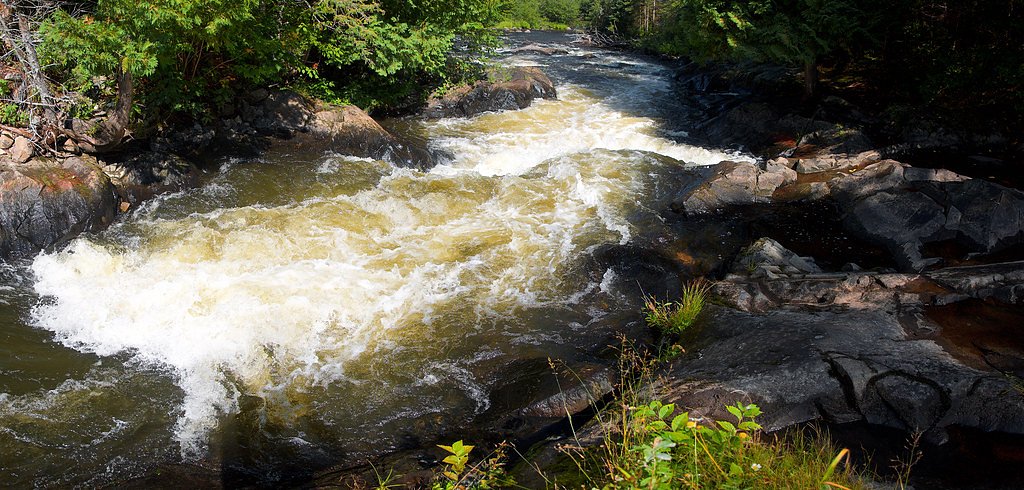
Current Water Conditions
177 ft³/s
Current discharge — how much water is flowing
About average for this time of year
Based on 78 years of record
4.66 ft
Water depth at gauge
7-Day Discharge Trend
What does this mean for your visit?
Flow is about average for this time of year.
About This Gauge
This gauge is on a nearby waterway and may not reflect exact conditions at the falls.
7-Day Flow Outlook
Based on the USGS gauge MIDDLE BRANCH ONTONAGON RIVER NEAR PAULDING, MI (9 km away).
Today
Moderate
177 cfs
8/10Tomorrow
Moderate
194 cfs
5/10Mon
Moderate
210 cfs
6/10Tue
Moderate
207 cfs
6/10Wed
Moderate
205 cfs
6/10Thu
Moderate
207 cfs
6/10Fri
Moderate
199 cfs
6/10Best window: Today — moderate flow, sunny (trip score 8/10).
Best time of year: this gauge typically runs highest from late March to mid June, peaking in April.
How we calculate this
This is a transparent outlook, not a precise forecast. We take the waterfall's current flow strength (how it ranks against its historical normal for today, from the nearest USGS stream gauge), carry that ranking forward along the gauge's seasonal curve, and nudge it for forecast rain. Confidence is highest for the next day or two and falls further out. Always check official conditions and your own judgment before visiting — high flows can be dangerous.
Know when to go.
Get a free email alert when waterfalls near Watersmeet hit peak flow. We only send when conditions are worth the trip — no weekly newsletters, no spam.
Weather Forecast
Location & Access
Getting There
Rock Bluff Falls is located near the town of Munising in Michigan's Upper Peninsula. It is accessible via local roads, but specific directions may vary depending on the starting point. Visitors are advised to use GPS or consult local maps for the most accurate route.
Get Directions on Google MapsParking
Parking is typically available near the trailhead, but spaces may be limited during peak seasons.
Elevation
1,362 feet above sea level
Coordinates
46.373611° N, -89.184722° W
Land Management
Managed by USFS
Visitor Tips & Gear
Visit early in the day to avoid crowds, especially during the summer months. Bring insect repellent during warmer seasons, as mosquitoes can be prevalent in the area.
As an Amazon Associate, we earn from qualifying purchases.
This easy 1.0 miles hike is straightforward — comfortable trail shoes and plenty of water should do. Sun exposure on the trail makes good sun protection a must in summer.

Polarized Sunglasses (Knockaround)
Cuts glare off the water so you actually see the falls — and your photos turn out better too.

Columbia Watertight II Rain Jacket
Packs into its own pocket, seam-sealed, and keeps you dry from spray and surprise rain.

Earth Pak Waterproof Dry Bag
Keeps your phone and gear dry when waterfall mist soaks everything else.

Waterproof Phone Pouch (AiRunTech)
Cheap insurance — take photos right next to the falls without killing your phone.

JOBY GorillaPod Starter Kit
Wraps around railings and rocks for long-exposure waterfall shots — no flat surface needed.

Osprey Daylite Daypack
Light, organized, and just the right size for a day hike — fits water, snacks, and layers.
Where to Stay

Two Rivers Motel and Cabins of Kenton, MI

AmericInn by Wyndham Iron River

Lakeshore Motel Ice Lake

Phelps Cabin on 26 Acres with Fire Pit!
Browse vacation cabins and private rentals nearby
Unique outdoor stays — tents, yurts, and treehouses
Rent a campervan or RV for your waterfall road trip
Some links are affiliate links. We may earn a commission at no extra cost to you.
Nearby Campground
Iron River Ranger District
7.7 miles away · 0 sites
Iron River is located in Iron County, in the western portion of Michigan's Upper Peninsula, just seven miles from the Wisconsin border. The border is shared with the Nicolet National forest. The Iron River Ranger District is 138,000 acres in size. Recreation opportunities include two camping for fee campgrounds and two rustic campgrounds. Three wilderness areas are located on adjacent districts. The area's climate is truly unique for each season of the year. The weather is summarized as follows:
Book on Recreation.govAdditional Information
Nearby Attractions
Nearby attractions include Pictured Rocks National Lakeshore, Munising Falls, and Miners Castle.
Wildlife
The area is home to a variety of wildlife, including birds, deer, and small mammals. Visitors should be cautious of ticks during warmer months.
Cities near Rock Bluff Falls
Nearby Waterfalls

Writing about Rock Bluff Falls? Embed this waterfall on your site for free.