


Photo Credits (5)
Difficulty
Easy
Trail Length
0.6 miles
Trail Type
Out And Back
Elevation Gain
80 ft
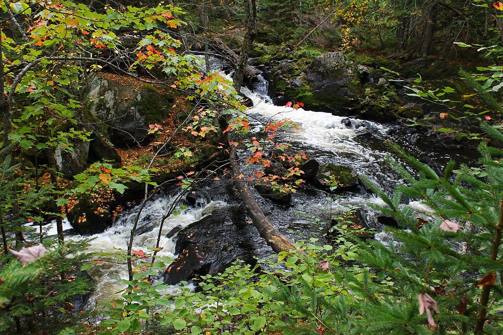
About Wolverine Falls
Wolverine Falls is a quiet, lesser-known cascade tucked into the forested banks of the Ontonagon unit of the Michigan Wild and Scenic River, managed by the U.S. Forest Service. The falls offer a peaceful spot for photographers and families alike, with seasonal flow that peaks in spring from snowmelt and diminishes in drier months. Because it isn’t a high-traffic destination, the setting feels intimate and prime for a short, restorative outing. A short approach makes Wolverine Falls an easy add-on to a day of exploring the western Upper Peninsula. The route to the falls is a brief 0.6-mile out-and-back with about 80 feet of elevation gain, so most hikers can enjoy the view without a long commitment. As it sits on USFS-managed land within the Michigan Wild and Scenic River corridor, visitors should follow Leave No Trace practices and respect any site-specific guidance posted by the Forest Service.
The Setting
Wolverine Falls sits at 1,302 feet within Ontonagon, Michigan Wild and Scenic River, fed by the Cisco Branch Ontonagon R, in the foothills of Michigan.
Trail & Hike Details
The Approach
The easy 0.6-mile out-and-back trail gains 80 feet of elevation on the way to the falls.
Trail Description
The U.S. Forest Service records the approach to Wolverine Falls as a 0.6-mile out-and-back trail with roughly 80 feet of elevation gain and an overall difficulty rating of easy. Specific USFS trail surface, grade, and technical class are not specified in available records; the short route is suitable for most hikers and families but may include natural, uneven footing typical of wooded river corridors. No official USFS trail number/name is listed for this route—check local Forest Service notices or on-site signage for the latest conditions before you go.
What to Expect
Expect a tranquil natural setting with a waterfall surrounded by forest. The flow of the waterfall may vary depending on the season, with spring offering the most dramatic views.
Accessibility
The trail is short and relatively flat, but the surface may be uneven. Contact the managing agency for accessibility details.
Frequently Asked Questions
🐶 Are Dogs Allowed at Wolverine Falls?
❌ Dogs are not allowed
Are There Any Fees or Permits Required?
🆖 No fees required
🏊 Is There Swimming at Wolverine Falls?
❌ Swimming is not allowed
When to Visit
Spring is typically the best time to visit due to higher water flow from snowmelt. Summer and fall also offer pleasant conditions, but the flow may be reduced.
Seasonal Access
The best time to visit is Spring, Summer, and Fall. Winter access may be limited.
Safety Information
Visitors should be cautious of slippery rocks near the waterfall and uneven terrain on the trail. Always stay on marked paths if available and avoid visiting during severe weather.
Current Water Conditions
17 ft³/s
Current discharge — how much water is flowing
About average for this time of year
Based on 81 years of record
4.38 ft
Water depth at gauge
7-Day Discharge Trend
What does this mean for your visit?
Flow is about average for this time of year.
About This Gauge
This gauge is on a nearby waterway and may not reflect exact conditions at the falls.
7-Day Flow Outlook
Based on the USGS gauge CISCO BRANCH ONTONAGON R AT CISCO LAKE OUTLET, MI (19 km away).
Today
Barely Flowing
17 cfs
5/10Tomorrow
Barely Flowing
23 cfs
5/10Sun
Barely Flowing
27 cfs
3/10Mon
Low
27 cfs
3/10Tue
Low
20 cfs
3/10Wed
Low
27 cfs
3/10Thu
Low
24 cfs
3/10Best window: Today — barely flowing flow, partly sunny (trip score 5/10).
Best time of year: this gauge typically runs highest from mid October to early December, peaking in April.
How we calculate this
This is a transparent outlook, not a precise forecast. We take the waterfall's current flow strength (how it ranks against its historical normal for today, from the nearest USGS stream gauge), carry that ranking forward along the gauge's seasonal curve, and nudge it for forecast rain. Confidence is highest for the next day or two and falls further out. Always check official conditions and your own judgment before visiting — high flows can be dangerous.
Know when to go.
Get a free email alert when waterfalls near Ewen hit peak flow. We only send when conditions are worth the trip — no weekly newsletters, no spam.
Weather Forecast
Location & Access
Getting There
The exact location and access details for Wolverine Falls are not well-documented. Visitors are advised to consult local resources or hiking guides for the most accurate directions.
Get Directions on Google MapsParking
Parking availability is unclear. It is recommended to check with local authorities or nearby trailheads for parking options.
Elevation
1,302 feet above sea level
Coordinates
46.405502° N, -89.349035° W
Land Management
Managed by USFS
Visitor Tips & Gear
Bring sturdy footwear and be prepared for potentially unmarked trails. Check weather conditions before visiting, as trails may become muddy or slippery after rain.
As an Amazon Associate, we earn from qualifying purchases.
For this easy 0.6 miles trail, lightweight trail shoes and a water bottle are usually sufficient. Sun exposure on the trail makes good sun protection a must in summer.

Polarized Sunglasses (Knockaround)
Cuts glare off the water so you actually see the falls — and your photos turn out better too.

Columbia Watertight II Rain Jacket
Packs into its own pocket, seam-sealed, and keeps you dry from spray and surprise rain.

Earth Pak Waterproof Dry Bag
Keeps your phone and gear dry when waterfall mist soaks everything else.

Waterproof Phone Pouch (AiRunTech)
Cheap insurance — take photos right next to the falls without killing your phone.

JOBY GorillaPod Starter Kit
Wraps around railings and rocks for long-exposure waterfall shots — no flat surface needed.

Osprey Daylite Daypack
Light, organized, and just the right size for a day hike — fits water, snacks, and layers.
Where to Stay

Boulder Bear Motor Lodge

Two Rivers Motel and Cabins of Kenton, MI

Phelps Cabin on 26 Acres with Fire Pit!

Northwoods Vacation Cisco Chain
Browse vacation cabins and private rentals nearby
Unique outdoor stays — tents, yurts, and treehouses
Rent a campervan or RV for your waterfall road trip
Some links are affiliate links. We may earn a commission at no extra cost to you.
Nearby Campground
SYLVANIA WILDERNESS BACKCOUNTRY CAMPING
11.3 miles away · 50 sites
Overview Planning a trip to the Sylvania Wilderness? Watch for Alerts at the top of the page for any Alerts regarding this facility. Encompassing one of the largest tracts of remaining old growth forest in the Midwest, the Sylvania Wilderness encompasses 18,327 acres and is part of the National Wilderness Preservation System. 34 named lakes are within its boundary. Recreation opportunities include canoeing on Sylvania's undeveloped lakes, hiking through its old growth forest, and camping at one
Book on Recreation.govAdditional Information
Nearby Attractions
Nearby attractions are not well-documented. Visitors may explore other natural areas or parks in Michigan for additional outdoor activities.
Wildlife
The area may host typical Michigan wildlife such as deer, birds, and small mammals. Be cautious of ticks and other insects.
Cities near Wolverine Falls
Nearby Waterfalls
Other waterfalls named Wolverine Falls
1 other waterfall shares this name across the U.S.
Writing about Wolverine Falls? Embed this waterfall on your site for free.