Nesowadnehunk Falls
By Armen Suny · Last verified May 2026
Difficulty
Moderate
Trail Length
2.4 miles
Trail Type
Out And Back
Elevation Gain
350 ft
About Nesowadnehunk Falls
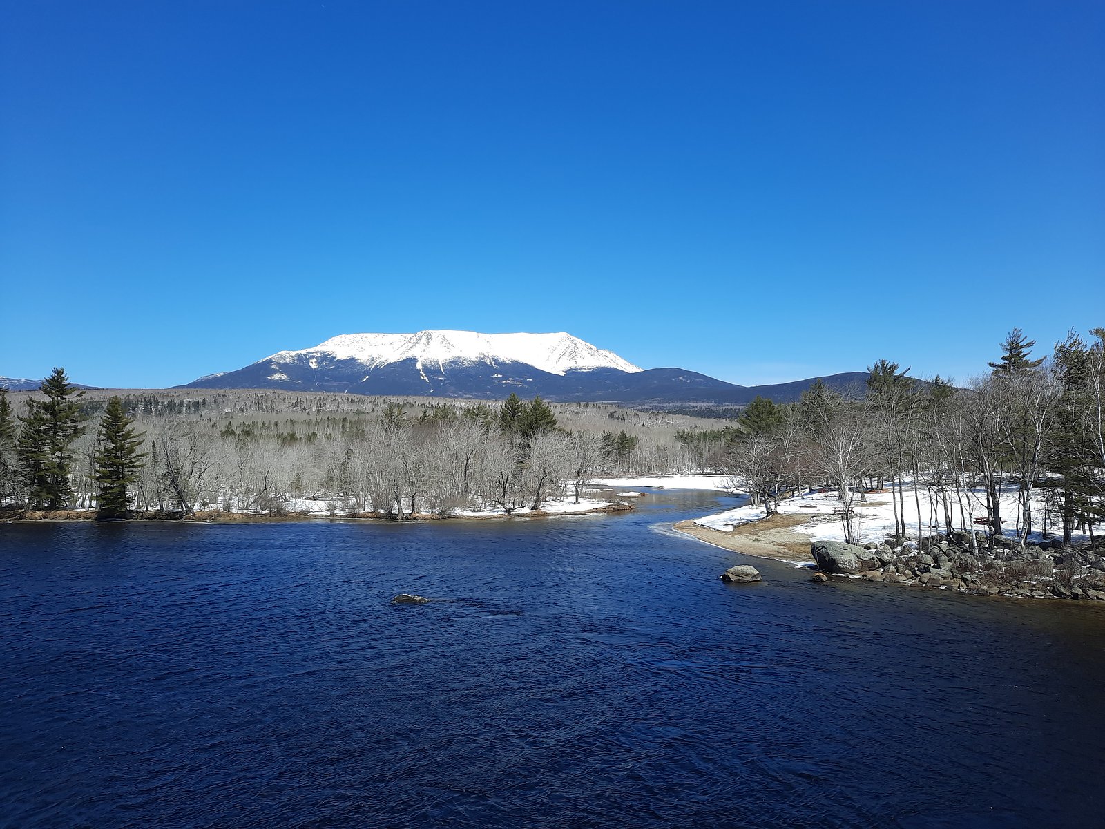
Nesowadnehunk Falls is a scenic cascade on the Nesowadnehunk Stream tucked into the forested reaches of Baxter State Park. The falls’ series of drops and pools make it a favorite stop for photographers and hikers seeking a tranquil slice of Maine’s north woods, with the river’s movement and surrounding spruce-fir forest offering a peaceful, photogenic setting. The walk to the falls is an approachable outing for anyone comfortable with a moderate hike: the route is a 2.4-mile out-and-back with about 350 feet of elevation gain, typically rated Moderate. Nestled within Baxter State Park, the trail follows the stream corridor and rewards visitors with repeated water views and the quiet solitude the park is known for, making it an excellent half-day outing for nature lovers and day hikers.
The Setting
Nesowadnehunk Falls sits at 584 feet along the East Branch Penobscot River, in the foothills of Maine.
Trail & Hike Details
The Approach
The moderate 2.4-mile out-and-back trail gains 350 feet of elevation on the way to the falls.
Trail Description
This is a 2.4-mile out-and-back trail that gains roughly 350 feet and is generally rated Moderate. The route follows the Nesowadnehunk Stream through forested terrain to reach the falls, offering repeated streamside views. Official USFS trail surface/grade/class data and a trail number are not applicable or not provided for this Baxter State Park route; expect a natural, unpaved hiking surface with some short ups and downs rather than paved or heavily engineered tread.
What to Expect
Visitors can expect a serene and scenic experience with the sound of rushing water and opportunities to observe local wildlife. The falls are surrounded by lush forest, providing a peaceful atmosphere.
Accessibility
The trail is not wheelchair accessible. Uneven terrain and elevation changes require steady footing.
Frequently Asked Questions
🐶 Are Dogs Allowed at Nesowadnehunk Falls?
❌ Dogs are not allowed
Are There Any Fees or Permits Required?
🤑 Fee: $0.00
🏊 Is There Swimming at Nesowadnehunk Falls?
❌ Swimming is not allowed
When to Visit
The best time to visit is during the spring and early summer when water flow is at its peak, or in the fall for stunning foliage views.
Seasonal Access
The best time to visit is Spring, Summer, and Fall. Winter access may be limited.
Safety Information
Exercise caution near the falls as rocks can be slippery. Be aware of changing weather conditions and carry a map of the park. Cell phone service is limited in the area.
Current Water Conditions
Based on a USGS gauge 22.7 miles away
2,250 ft³/s
Current discharge — how much water is flowing
About average for this time of year
Based on 104 years of record
6.33 ft
Water depth at gauge
7-Day Discharge Trend
What does this mean for your visit?
Flow is about average for this time of year.
About This Gauge
This gauge is on a regional waterway. Conditions at the falls may differ, especially after local rain.
7-Day Flow Outlook
Based on the USGS gauge East Branch Penobscot River at Grindstone, Maine (37 km away).
Today
Low
2430 cfs
4/10Tomorrow
Moderate
2617 cfs
4/10Sun
Moderate
2475 cfs
5/10Mon
Low
2187 cfs
6/10Tue
Moderate
2435 cfs
4/10Wed
Moderate
2344 cfs
5/10Thu
Moderate
2191 cfs
5/10Best window: Mon — low flow, sunny (trip score 6/10).
Best time of year: this gauge typically runs highest from late March to late June, peaking in April.
How we calculate this
This is a transparent outlook, not a precise forecast. We take the waterfall's current flow strength (how it ranks against its historical normal for today, from the nearest USGS stream gauge), carry that ranking forward along the gauge's seasonal curve, and nudge it for forecast rain. Confidence is highest for the next day or two and falls further out. Always check official conditions and your own judgment before visiting — high flows can be dangerous.
Know when to go.
Get a free email alert when waterfalls near Brownville Junction hit peak flow. We only send when conditions are worth the trip — no weekly newsletters, no spam.
Weather Forecast
Location & Access
Getting There
Nesowadnehunk Falls is located within Baxter State Park. Visitors can access the park via the Togue Pond Gate or Matagamon Gate. The falls are situated along the Nesowadnehunk Stream, near the park's Tote Road.
Get Directions on Google MapsParking
Parking is available at designated areas within Baxter State Park. Visitors should check with park staff for the closest parking area to the falls.
Elevation
584 feet above sea level
Coordinates
45.846712° N, -69.030047° W
Visitor Tips & Gear
Wear sturdy footwear as the trail may have uneven sections. Bring insect repellent, especially during the summer months. Check Baxter State Park's rules and regulations before visiting.
As an Amazon Associate, we earn from qualifying purchases.
With 2.4 miles and 350 ft of elevation gain, sturdy boots and trekking poles will help on this moderate trail. Sun exposure on the trail makes good sun protection a must in summer.

Polarized Sunglasses (Knockaround)
Cuts glare off the water so you actually see the falls — and your photos turn out better too.

Columbia Watertight II Rain Jacket
Packs into its own pocket, seam-sealed, and keeps you dry from spray and surprise rain.

Earth Pak Waterproof Dry Bag
Keeps your phone and gear dry when waterfall mist soaks everything else.

Waterproof Phone Pouch (AiRunTech)
Cheap insurance — take photos right next to the falls without killing your phone.

Timberland Euro Sprint Mid Waterproof
Trusted waterproof boot with premium leather and grippy rubber sole — reliable on rocky, wet trails.

TrailBuddy Trekking Poles
Lightweight aluminum, cork grips, and flip-locks that actually hold — a best-seller for good reason.
Where to Stay

Waterfront home on Moosehead Lake

Baxter Park Inn

Hotel Terrace

Family Friendly Lakefront Cottage, Ambajejus Lake
Browse vacation cabins and private rentals nearby
Unique outdoor stays — tents, yurts, and treehouses
Rent a campervan or RV for your waterfall road trip
Some links are affiliate links. We may earn a commission at no extra cost to you.
Nearby Campground
Katahdin Woods and Waters National Monument Camping and Huts
22.2 miles away · 27 sites
Overview Katahdin Woods and Waters National Monument is located in Maine’s north woods. Katahdin Woods and Waters protects part of an extraordinary natural and cultural landscape: the mountains, woods, and waters where the East Branch of the Penobscot River and its tributaries, including the Wassataquoik Stream and the Seboeis River, run freely. Campsites, lean-tos and huts located throughout the monument provide opportunities to stay overnight while hiking, biking, paddling and enjoying other re
Book on Recreation.govAdditional Information
Nearby Attractions
Other attractions in Baxter State Park include Katahdin Stream Falls, Daicey Pond, and Mount Katahdin.
Wildlife
Visitors may encounter moose, deer, and a variety of bird species. Always observe wildlife from a safe distance.
Cities near Nesowadnehunk Falls
Nearby Waterfalls
Writing about Nesowadnehunk Falls? Embed this waterfall on your site for free.