
Photo Credits (5)
Difficulty
Moderate
Trail Length
3.0 miles
Trail Type
Out And Back
Elevation Gain
500 ft
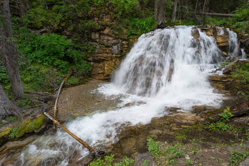
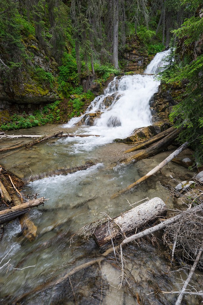
About Double Falls
Double Falls sits within the Lewis & Clark National Forest and is managed by the U.S. Forest Service, offering a peaceful forest setting that's easy to reach for a half-day outing. The waterfall is reached from North Fork Ford Creek and is a popular short hike for visitors wanting a quick nature escape without a long backcountry commitment. With a nearby campground just 0.15 km away at Double Falls Campground, it’s also a convenient option for an overnight stay under the pines. Access is via the USFS North Fork Ford Creek Trail (Trail #284). USFS mapping shows a 0.26-mile GIS segment for the trail, and the route commonly enjoyed by hikers is an out-and-back of about 3.0 miles total with roughly 500 feet of elevation gain. The hike is typically rated moderate—inviting for hikers who want a manageable climb and a scenic payoff at the falls.
The Setting
Double Falls sits at 5,299 feet within Lewis & Clark National Forest, fed by the Sun River Bl Diversion Dam, in the high mountains of Montana.
Trail & Hike Details
The Approach
The moderate hike follows North Fork Ford Creek (#284), a 3.0-mile out-and-back trail over natural surface. Expect 500 feet of elevation gain. The trail is moderately developed (Class 2).
USFS Trail
NORTH FORK FORD CREEK #284
Trail Class
Moderately Developed
Surface
USFS Segment
0.26 miTrail Description
Follow the USFS North Fork Ford Creek Trail (Trail #284) to reach Double Falls. The trail is classified as Class 2 and is surfaced with native material, so expect a natural dirt and root-strewn footing rather than a built or paved path. The commonly used route is an out-and-back of about 3.0 miles round-trip with approximately 500 feet of elevation gain and is rated moderate; USFS GIS data also notes a 0.26-mile mapped segment for the trail. Wear sturdy footwear for uneven or rocky sections, and plan for a quick walk-in if you’re staying at the nearby Double Falls Campground (0.15 km).
What to Expect
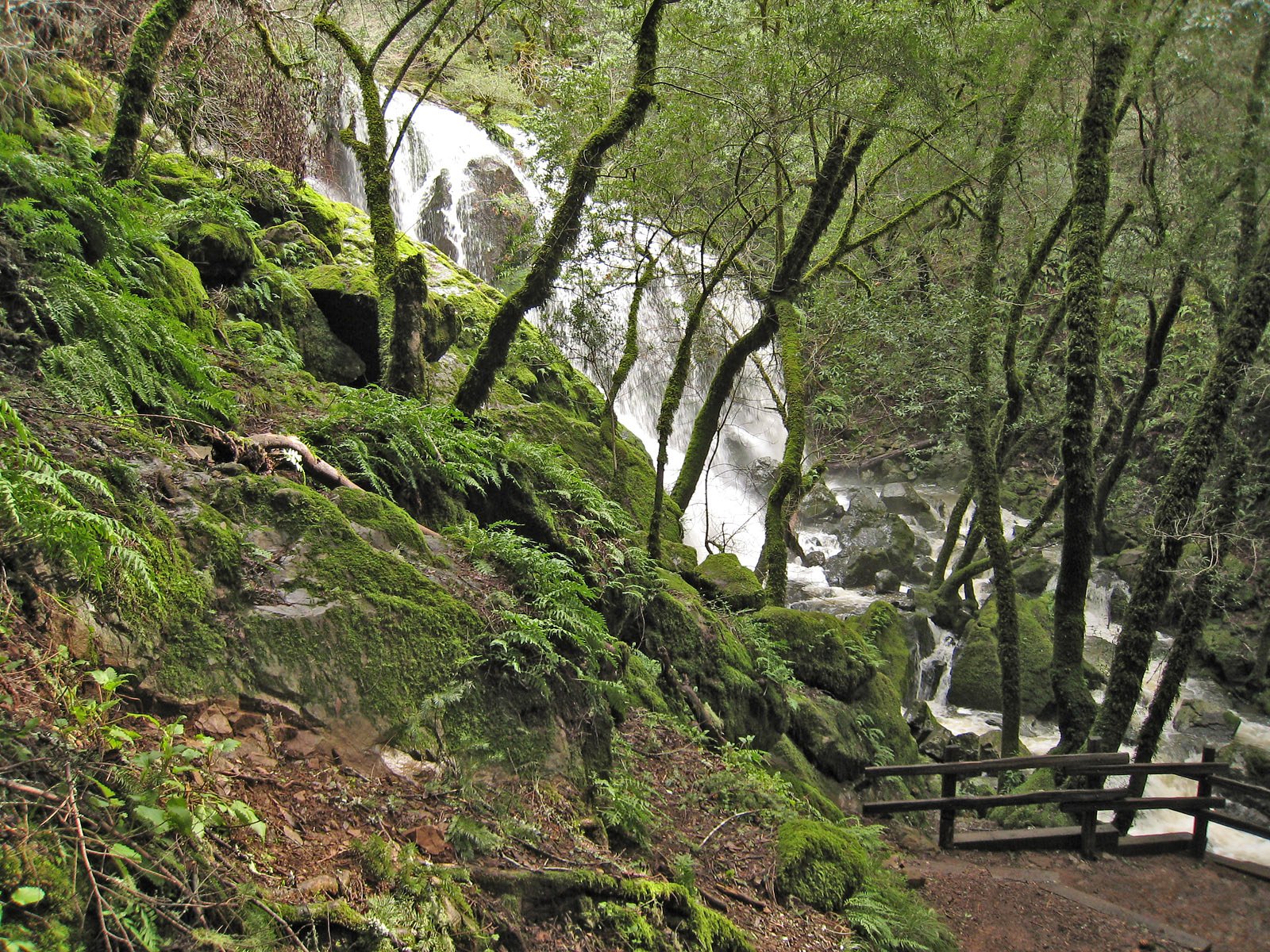
Visitors can expect a tranquil hike through nature, culminating in a view of Double Falls cascading over a rocky cliff. The area around the falls is typically quiet and offers opportunities for photography and relaxation.
Accessibility
The trail is not wheelchair accessible. Uneven terrain and elevation changes require steady footing.
Frequently Asked Questions
🐶 Are Dogs Allowed at Double Falls?
❌ Dogs are not allowed
Are There Any Fees or Permits Required?
🆖 No fees required
🏊 Is There Swimming at Double Falls?
❌ Swimming is not allowed
When to Visit
Spring and early summer are ideal for visiting, as the waterfall is likely to have the highest flow due to snowmelt. Fall offers beautiful foliage, while summer provides warmer weather.
Seasonal Access
The best time to visit is Spring, Summer, and Fall. Access roads and trails may close during winter due to snow. Check with Lewis & Clark National Forest for seasonal road closures.
Safety Information
Be cautious of slippery rocks near the falls and stay on marked trails to avoid getting lost. Carry bear spray and be aware of wildlife in the area.
Current Water Conditions
132 ft³/s
Current discharge — how much water is flowing
Lower than usual for this time of year
Based on 23 years of record
3.73 ft
Water depth at gauge
7-Day Discharge Trend
What does this mean for your visit?
Flow is lower than usual for this time of year.
About This Gauge
This gauge is on a nearby waterway and may not reflect exact conditions at the falls.
7-Day Flow Outlook
Based on the USGS gauge Sun River bl Diversion Dam nr Augusta MT (24 km away).
Today
Low
163 cfs
3/10Tomorrow
Low
156 cfs
3/10Sun
Low
147 cfs
4/10Mon
Low
163 cfs
3/10Tue
Barely Flowing
140 cfs
5/10Wed
Low
113 cfs
3/10Thu
Low
116 cfs
3/10Best window: Tue — barely flowing flow, partly sunny (trip score 5/10).
Best time of year: this gauge typically runs highest from late April to early July, peaking in June.
How we calculate this
This is a transparent outlook, not a precise forecast. We take the waterfall's current flow strength (how it ranks against its historical normal for today, from the nearest USGS stream gauge), carry that ranking forward along the gauge's seasonal curve, and nudge it for forecast rain. Confidence is highest for the next day or two and falls further out. Always check official conditions and your own judgment before visiting — high flows can be dangerous.
Know when to go.
Get a free email alert when waterfalls near Augusta hit peak flow. We only send when conditions are worth the trip — no weekly newsletters, no spam.
Weather Forecast
Location & Access
Getting There
Double Falls is located within a remote area of Montana. Access typically requires driving to a trailhead, followed by a hike. Specific directions may vary depending on the starting point, so consulting a map or local resources is recommended.
Get Directions on Google MapsParking
Parking is available at the trailhead, but spaces may be limited during peak seasons.
Elevation
5,299 feet above sea level
Coordinates
47.406943° N, -112.723894° W
Land Management
Managed by USFS
Visitor Tips & Gear
Start your hike early to avoid crowds and ensure you have enough daylight for the return trip. Bring plenty of water and snacks, as there are no facilities along the trail.
This trail sits at 5,299 ft above sea level
Elevated TrailUV radiation is roughly 21% stronger at this elevation than at sea level, and the dry air accelerates dehydration. Extra sun protection and fluids go a long way.
As an Amazon Associate, we earn from qualifying purchases.

Coppertone Sport SPF 50 Sunscreen
UV intensity jumps ~4% per 1,000 ft — at this elevation you can burn in half the time.

Sun Bum SPF 30 Lip Balm (3-Pack)
Lips have almost no natural UV protection and burn fast in thin, dry mountain air.

Liquid I.V. Electrolyte Packets
You lose moisture ~2x faster at elevation — electrolytes help you absorb water efficiently.

ROCKNIGHT Polarized UV400 Sunglasses
High-altitude glare off rock and water is intense — UV400 lenses block 99%+ of UVA/UVB.
As an Amazon Associate, we earn from qualifying purchases.
With 3.0 miles and 500 ft of elevation gain, sturdy boots and trekking poles will help on this moderate trail. Sun exposure on the trail makes good sun protection a must in summer.

Polarized Sunglasses (Knockaround)
Cuts glare off the water so you actually see the falls — and your photos turn out better too.

Columbia Watertight II Rain Jacket
Packs into its own pocket, seam-sealed, and keeps you dry from spray and surprise rain.

Earth Pak Waterproof Dry Bag
Keeps your phone and gear dry when waterfall mist soaks everything else.

Waterproof Phone Pouch (AiRunTech)
Cheap insurance — take photos right next to the falls without killing your phone.

Timberland Euro Sprint Mid Waterproof
Trusted waterproof boot with premium leather and grippy rubber sole — reliable on rocky, wet trails.

TrailBuddy Trekking Poles
Lightweight aluminum, cork grips, and flip-locks that actually hold — a best-seller for good reason.
Where to Stay

Remote Wolf Creek Cabin - Wide Open Spaces!

Pet-Friendly Augusta Cabin - Walk to Main Street!

Cozy Augusta Cabin with Grill - Walk to Main St

Cozy Augusta Cabin w/ Furnished Deck & Grill!
Browse vacation cabins and private rentals nearby
Unique outdoor stays — tents, yurts, and treehouses
Rent a campervan or RV for your waterfall road trip
Some links are affiliate links. We may earn a commission at no extra cost to you.
Nearby Campground
Double Falls Campground
0.1 miles away · 0 sites
CampgroundBears may frequent the area; keep all food out of sight in approved containers and remove all food from area after eating. Mandatory food storage is required.
Book on Recreation.govNearby Hot Springs
Hot springs near Augusta, Montana
Medicine (Sun River) Springs
Medicine Springs, also called Sun River Springs, flows at 86°F at 4,816 feet elevation in Teton County, Montana, near the bound...
Bearmouth Warm Spring 2
Bearmouth Warm Spring 2 flows at 68°F in Granite County, Montana, at 3,977 feet elevation -- about 170 feet higher than its com...
Bearmouth Warm Spring 1
Bearmouth Warm Spring 1 surfaces at 68°F directly beside a road in Granite County, Montana, at 3,807 feet elevation. With only ...
Nimrod Springs
Nimrod Springs flows at 70°F with hard, sulfate-rich water carrying 323 mg/L sulfate and 137 mg/L calcium at near-neutral pH 7....
Looking for a soak after your hike? Explore more hot springs near Augusta, Montana on SoakingSprings.
Explore Montana springsAdditional Information
Nearby Attractions
Nearby attractions may include other hiking trails, scenic viewpoints, and local wildlife areas.
Wildlife
The area is home to a variety of wildlife, including deer, birds, and small mammals. Be cautious of bears and carry bear spray if hiking in bear country.
Cities near Double Falls
Nearby Waterfalls
Other waterfalls named Double Falls
3 other waterfalls share this name across the U.S.
Writing about Double Falls? Embed this waterfall on your site for free.