Photo Credits (5)
Difficulty
Moderate
Trail Length
2.4 miles
Trail Type
Out And Back
Elevation Gain
350 ft
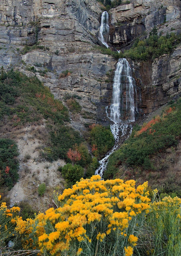
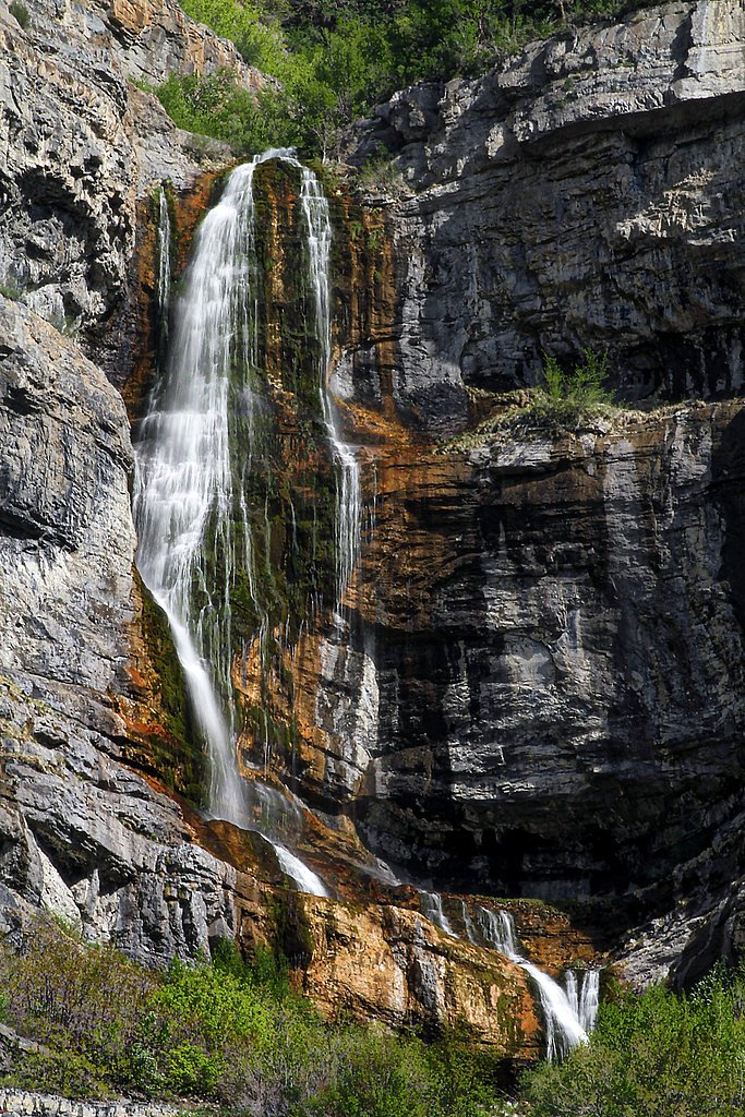
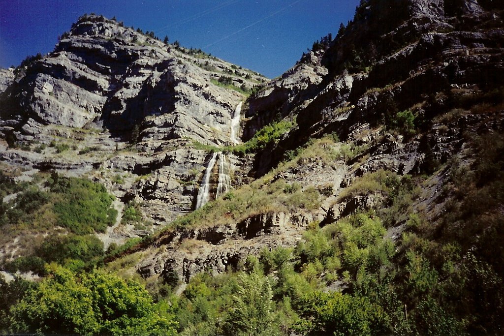
About Double Falls
Double Falls is a secluded, lesser-known waterfall tucked inside Zion National Park and managed by the National Park Service. Its twin cascades spill into a quiet pool framed by the park’s dramatic canyon walls, offering a peaceful reward for hikers willing to leave the busier viewpoints behind. The setting feels intimate and restorative, ideal for photography, a picnic, or a brief escape into the park’s quieter corners. The route to the falls is a moderate out-and-back hike of 2.4 miles with about 350 feet of elevation gain, making it accessible to many day-hikers who are prepared for a few uphill pitches. If you plan to camp, South Campground is the nearest option inside the park, roughly 9.43 km away, so an overnight at Zion makes a convenient base for exploring Double Falls and other nearby trails. As a National Park feature administered by the NPS, visitors should follow park regulations and leave no trace to help preserve this peaceful spot.
The Setting
Double Falls sits at 4,803 feet within Zion National Park, fed by the North Fork Virgin River, in the mountains of Utah.
Trail & Hike Details
The Approach
The moderate 2.4-mile out and back trail gains 350 feet of elevation on the way to the falls.
Trail Description
This NPS-managed route to Double Falls is an out-and-back trail totaling 2.4 miles with approximately 350 feet of elevation gain. The hike is rated moderate and is suitable for hikers comfortable with some uphill sections; expect a mix of level walking and short climbs. Specific surface, grade, and trail-class details are not listed in the park’s summary data, so bring sturdy footwear and be prepared for typical backcountry conditions within Zion National Park.
What to Expect
Visitors can expect a peaceful hike through desert terrain with the reward of a stunning dual waterfall at the end. The area is remote, so it is important to come prepared with water and supplies.
Accessibility
The trail is not wheelchair accessible. Uneven terrain and elevation changes require steady footing.
Frequently Asked Questions
🐶 Are Dogs Allowed at Double Falls?
❌ Dogs are not allowed
Are There Any Fees or Permits Required?
🆖 No fees required
🏊 Is There Swimming at Double Falls?
❌ Swimming is not allowed
When to Visit
Spring and early summer are the best times to visit, as the waterfall flow is typically stronger due to snowmelt and seasonal rains.
Seasonal Access
The best time to visit is Spring, Summer, and Fall. Winter access may be limited. Watch for flash flood warnings during monsoon season (July through September). Check with Zion National Park for current conditions.
Safety Information
Visitors should be prepared for remote conditions. Bring plenty of water, as there are no facilities nearby. Watch for flash floods during rainy weather, and avoid hiking during extreme heat.
Current Water Conditions
29 ft³/s
Current discharge — how much water is flowing
Lower than usual for this time of year
Based on 37 years of record
7.04 ft
Water depth at gauge
65°F
CoolRefreshing for swimming
7-Day Discharge Trend
What does this mean for your visit?
Flow is lower than usual for this time of year. Water temperature is a refreshing 65 degrees F, good for a quick swim.
About This Gauge
This gauge is on a nearby waterway and may not reflect exact conditions at the falls.
7-Day Flow Outlook
Based on the USGS gauge NORTH FORK VIRGIN RIVER NEAR SPRINGDALE, UT (9 km away).
Today
Moderate
29 cfs
9/10Tomorrow
Moderate
29 cfs
9/10Sun
Moderate
29 cfs
9/10Mon
Moderate
29 cfs
9/10Tue
Moderate
28 cfs
9/10Wed
Moderate
28 cfs
9/10Thu
Moderate
27 cfs
9/10Best window: Today — moderate flow, patchy blowing dust (trip score 9/10).
Best time of year: this gauge typically runs highest from early March to early June, peaking in April.
How we calculate this
This is a transparent outlook, not a precise forecast. We take the waterfall's current flow strength (how it ranks against its historical normal for today, from the nearest USGS stream gauge), carry that ranking forward along the gauge's seasonal curve, and nudge it for forecast rain. Confidence is highest for the next day or two and falls further out. Always check official conditions and your own judgment before visiting — high flows can be dangerous.
Know when to go.
Get a free email alert when waterfalls near Springdale hit peak flow. We only send when conditions are worth the trip — no weekly newsletters, no spam.
Weather Forecast
Location & Access
Getting There
Double Falls is located in the Grand Staircase-Escalante National Monument area. Access typically involves driving on dirt roads, which may require a high-clearance vehicle, especially after rain. Specific directions should be confirmed with local visitor centers or reliable navigation tools.
Get Directions on Google MapsParking
Parking is available near the trailhead, but spaces may be limited. Visitors should check local conditions before traveling.
Hours
Elevation
4,803 feet above sea level
Coordinates
37.280537° N, -113.024665° W
Land Management
Managed by NPS
Visitor Tips & Gear
Check weather conditions before visiting, as dirt roads leading to the trailhead can become impassable after rain. Bring plenty of water, sunscreen, and sturdy footwear. Cell service may be limited in the area.
As an Amazon Associate, we earn from qualifying purchases.
With 2.4 miles and 350 ft of elevation gain, sturdy boots and trekking poles will help on this moderate trail. Sun exposure on the trail makes good sun protection a must in summer.
America the Beautiful Annual Pass
Covers entrance fees at 2,000+ federal recreation sites — required at most National Parks.

Polarized Sunglasses (Knockaround)
Cuts glare off the water so you actually see the falls — and your photos turn out better too.

Columbia Watertight II Rain Jacket
Packs into its own pocket, seam-sealed, and keeps you dry from spray and surprise rain.

Earth Pak Waterproof Dry Bag
Keeps your phone and gear dry when waterfall mist soaks everything else.

Waterproof Phone Pouch (AiRunTech)
Cheap insurance — take photos right next to the falls without killing your phone.

Timberland Euro Sprint Mid Waterproof
Trusted waterproof boot with premium leather and grippy rubber sole — reliable on rocky, wet trails.

TrailBuddy Trekking Poles
Lightweight aluminum, cork grips, and flip-locks that actually hold — a best-seller for good reason.
Where to Stay

Red Cliffs Lodge Zion, A Tribute Portfolio Hotel

Under Canvas Zion

Arrowhead Country Cabins

Zion White Bison Glamping & RV Resort
Browse vacation cabins and private rentals nearby
Unique outdoor stays — tents, yurts, and treehouses
Rent a campervan or RV for your waterfall road trip
Some links are affiliate links. We may earn a commission at no extra cost to you.
Nearby Campground
SOUTH CAMPGROUND (UT)
5.9 miles away · 123 sites
Overview Reservations for South Campground are available up to 14 days before your arrival and may extend up to two days beyond this 14-day booking window. For visitors to Zion National Park, South Campground is an ideal place to stay. Located near the park's south entrance, the campground is just a short walk from the main visitor center, the Zion Canyon Shuttle System and the adjacent town of Springdale. The canyon and most of the park's trails are only accessible by shuttle bus from approxima
Book on Recreation.govNearby Hot Springs
Hot springs near Springdale, Utah

Dixie (Laverkin) Hot Springs
Dixie Hot Springs flows at 108°F just 25 meters from road access in Washington County, making it one of southwestern Utah's hot...
Berry Springs
Berry Springs emerges at 75°F near Hurricane in Washington County, Utah, at 2,860 feet elevation in the red rock landscape of U...
Virgin River Spring
A 70-degree spring flowing at 2,760 feet elevation in Washington County, barely thermal at just 5.6 degrees above the warm ambi...
Red Canyon
Red Canyon Spring flows at 72°F at 5,360 feet elevation in Kane County's red rock country near Kanab, running 18.6 degrees abov...
Warner Valley Spring
Emerging at 70 degrees Fahrenheit in Warner Valley, this spring rises just 6.2 degrees above ambient at 2,720 feet elevation in...

Warm Spring
A 75-degree spring in Washington County near the city of Washington, flowing at 2,820 feet elevation with 341 mg/L total dissol...
Looking for a soak after your hike? Explore more hot springs near Springdale, Utah on SoakingSprings.
Explore Utah springsAdditional Information
Nearby Attractions
Other attractions in the Grand Staircase-Escalante National Monument include Calf Creek Falls and the Escalante River.
Wildlife
The area is home to desert wildlife such as lizards, birds, and small mammals. Visitors should be cautious of snakes, especially during warmer months.
Cities near Double Falls
Other waterfalls named Double Falls
3 other waterfalls share this name across the U.S.
Writing about Double Falls? Embed this waterfall on your site for free.