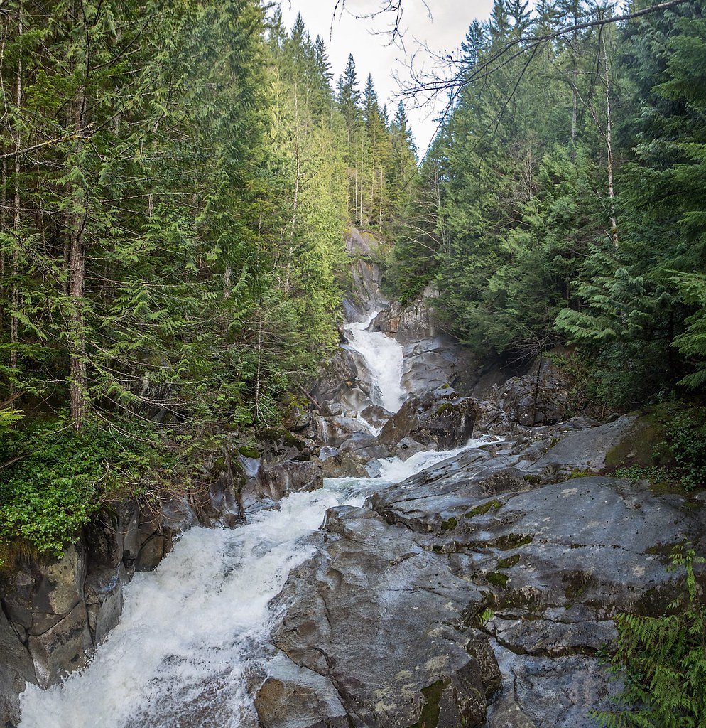
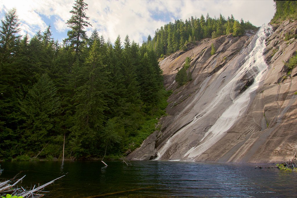
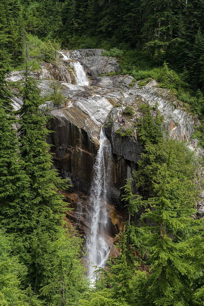
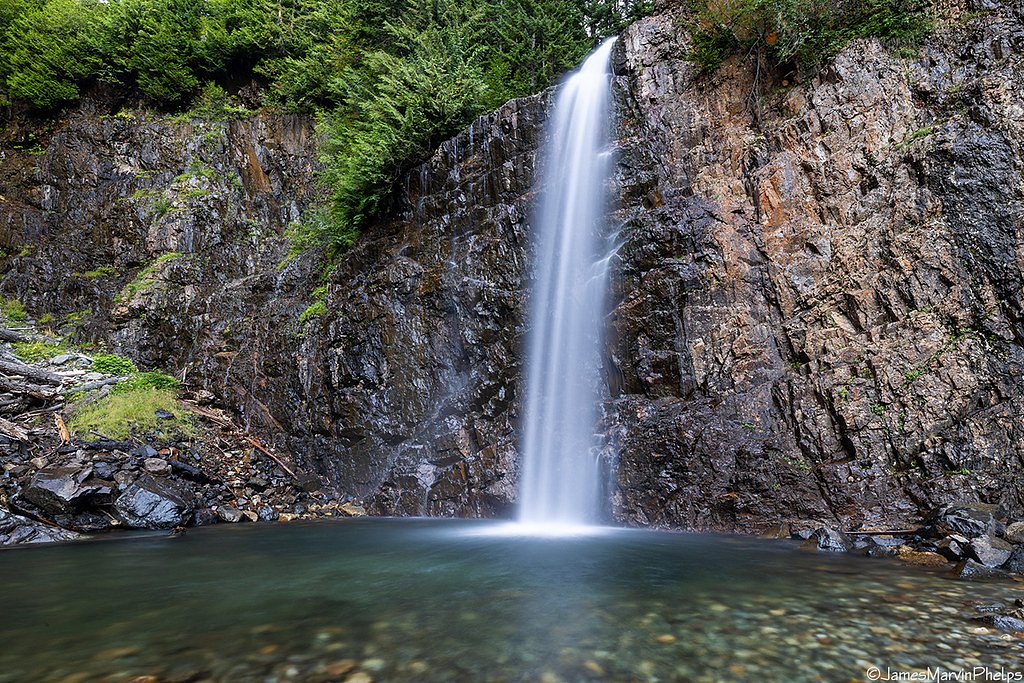
Dingford Creek Falls
By Armen Suny · Last verified Mar 2026
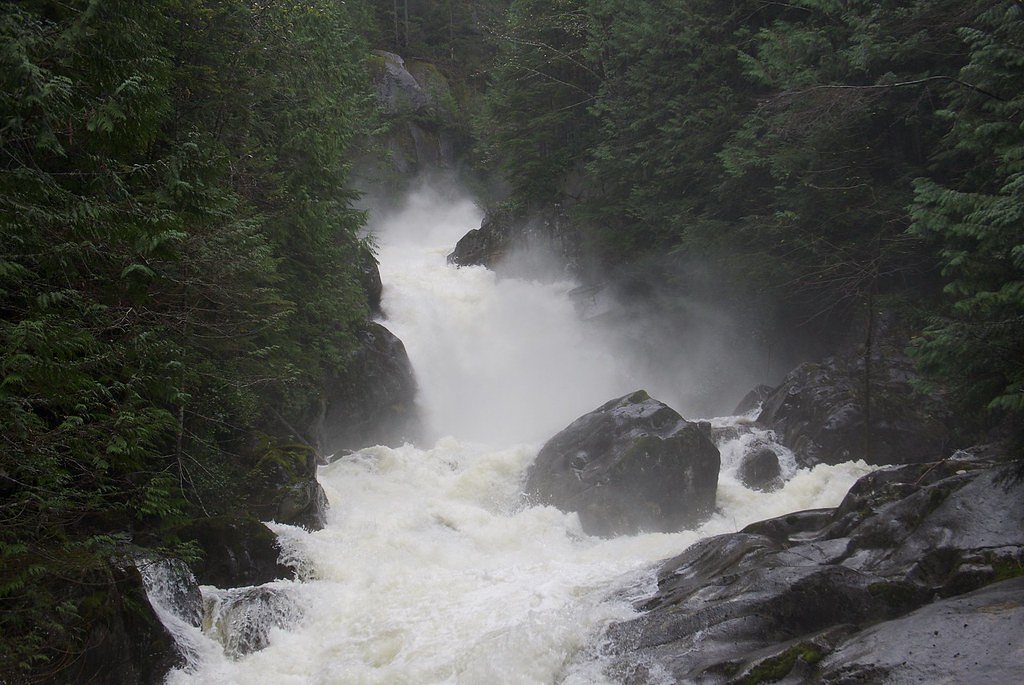
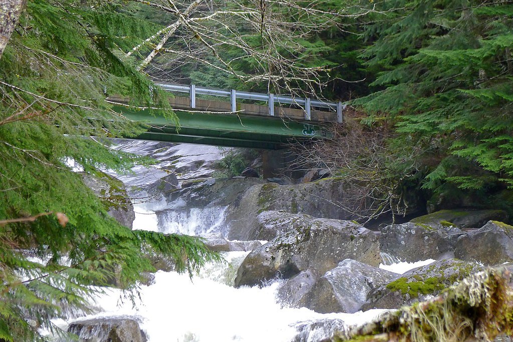
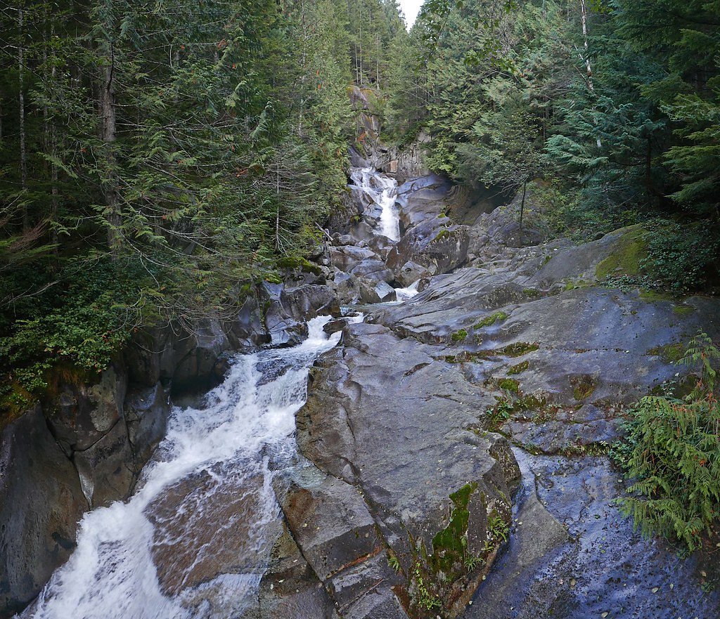
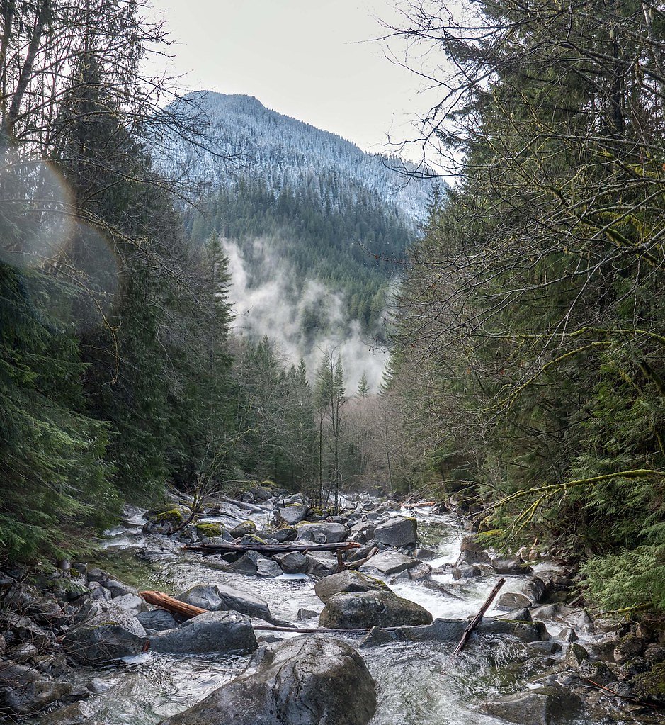

Photo Credits (5)
Difficulty
Moderate
Trail Length
2.5 miles
Trail Type
Out And Back
Elevation Gain
500 ft
About Dingford Creek Falls
Dingford Creek Falls is a scenic waterfall located in the Alpine Lakes Wilderness of Washington. It is a multi-tiered waterfall along Dingford Creek, surrounded by lush forest and rugged terrain. The falls are a popular destination for hikers exploring the Middle Fork Snoqualmie River area.
The Setting
Dingford Creek Falls sits at 1,299 feet within Snoqualmie National Forest, fed by the Middle Fork Snoqualmie River, in the foothills of Washington.
Trail & Hike Details
The Approach
The moderate hike follows Dingford Creek (#1005), a 2.5-mile out-and-back trail over natural surface. Expect 500 feet of elevation gain with grades of 12-20%. The trail is developed (Class 3).
USFS Trail
DINGFORD CREEK #1005
Trail Class
Developed
Surface
Avg Grade
USFS Segment
0.50 miTrail Description
The trail to Dingford Creek Falls follows the Dingford Creek Trail, which is well-maintained but can be rocky and uneven in places. The trail meanders through dense forest and crosses several small streams before reaching the falls. The waterfall is visible from the trail, but some scrambling may be required for closer views.
What to Expect
Dogs are welcome.
Accessibility
The trail is not wheelchair accessible. Uneven terrain and elevation changes require steady footing.
Frequently Asked Questions
🐶 Are Dogs Allowed at Dingford Creek Falls?
✅ Dogs are allowed
Are There Any Fees or Permits Required?
🤑 Fee: $5.00
Permit required
A Northwest Forest Pass or America the Beautiful Pass is required for parking at the trailhead.
🏊 Is There Swimming at Dingford Creek Falls?
❌ Swimming is not allowed
When to Visit
Spring and early summer are the best times to visit, as the waterfall is most active due to snowmelt.
Seasonal Access
The best time to visit is Spring, Summer, and Fall. Winter access may be limited. Check with Snoqualmie National Forest for seasonal road closures.
Safety Information
The trail can be slippery, especially after rain. Use caution when crossing streams or approaching the falls. Be prepared for changing weather conditions and carry the 10 essentials for hiking.
Current Water Conditions
562 ft³/s
Current discharge — how much water is flowing
Much lower than usual for this time of year
Based on 64 years of record
2.39 ft
Water depth at gauge
7-Day Discharge Trend
What does this mean for your visit?
Flow is well below normal for this time of year, so the waterfall may be a trickle.
About This Gauge
This gauge is on a nearby waterway and may not reflect exact conditions at the falls.
7-Day Flow Outlook
Based on the USGS gauge MIDDLE FORK SNOQUALMIE RIVER NEAR TANNER, WA (15 km away).
Today
Roaring
571 cfs
6/10Tomorrow
Roaring
621 cfs
6/10Mon
Roaring
554 cfs
6/10Tue
Roaring
516 cfs
6/10Wed
Roaring
502 cfs
6/10Thu
Roaring
526 cfs
6/10Fri
Roaring
507 cfs
6/10Best window: Today — roaring flow, light rain likely (trip score 6/10).
Best time of year: this gauge typically runs highest from late April to late June, peaking in June.
How we calculate this
This is a transparent outlook, not a precise forecast. We take the waterfall's current flow strength (how it ranks against its historical normal for today, from the nearest USGS stream gauge), carry that ranking forward along the gauge's seasonal curve, and nudge it for forecast rain. Confidence is highest for the next day or two and falls further out. Always check official conditions and your own judgment before visiting — high flows can be dangerous.
Know when to go.
Get a free email alert when waterfalls near Snoqualmie Pass hit peak flow. We only send when conditions are worth the trip — no weekly newsletters, no spam.
Weather Forecast
Location & Access
Getting There
Dingford Creek Falls is accessed via the Middle Fork Snoqualmie River Road (Forest Road 56). The trailhead for Dingford Creek Trail is located at the end of this road. The road may be rough and require a high-clearance vehicle, especially in wet conditions.
Get Directions on Google MapsParking
Parking is available at the Dingford Creek Trailhead, but spaces are limited. Overflow parking may require walking along the road to the trailhead.
Elevation
1,299 feet above sea level
Coordinates
47.514279° N, -121.455095° W
Land Management
Managed by USFS
Visitor Tips & Gear
Start early to secure parking and avoid crowds. Wear sturdy hiking boots as the trail can be rocky and slippery. Bring bug spray during summer months as mosquitoes can be prevalent.
As an Amazon Associate, we earn from qualifying purchases.
With 2.5 miles and 500 ft of elevation gain, sturdy boots and trekking poles will help on this moderate trail. Sun exposure on the trail makes good sun protection a must in summer.

Polarized Sunglasses (Knockaround)
Cuts glare off the water so you actually see the falls — and your photos turn out better too.

Columbia Watertight II Rain Jacket
Packs into its own pocket, seam-sealed, and keeps you dry from spray and surprise rain.

Earth Pak Waterproof Dry Bag
Keeps your phone and gear dry when waterfall mist soaks everything else.

Waterproof Phone Pouch (AiRunTech)
Cheap insurance — take photos right next to the falls without killing your phone.

Timberland Euro Sprint Mid Waterproof
Trusted waterproof boot with premium leather and grippy rubber sole — reliable on rocky, wet trails.

TrailBuddy Trekking Poles
Lightweight aluminum, cork grips, and flip-locks that actually hold — a best-seller for good reason.
Where to Stay

Snoqualmie Inn by Hotel America

Moon River Suites #5

Moon River Suites #3

The Summit Inn
Browse vacation cabins and private rentals nearby
Unique outdoor stays — tents, yurts, and treehouses
Rent a campervan or RV for your waterfall road trip
Some links are affiliate links. We may earn a commission at no extra cost to you.
Nearby Campground
Middle Fork Campground
4.7 miles away · 39 sites
Overview This campground is located along the Middle Fork of the scenic Snoqualmie River in Mt. Baker-Snoqualmie National Forest. Beneath a canopy of towering Douglas fir, cedar and Western hemlock, and located near several hiking trails within a short driving distance, this campground is a perfect site for both individual and small group camping excursions.Recreation In addition to being a prime location for hiking, fishing, horseback riding and picnicking in summer and early fall, Middle Fork o
Book on Recreation.govNearby Hot Springs
Hot springs near Snoqualmie Pass, Washington
Goldmeyer Hot Springs
Goldmeyer Hot Springs emerges at 127 degrees in the central Cascades, producing water 78.9 degrees above ambient temperature at...
Lester Hot Springs
This 120-degree spring sits within the City of Tacoma Watershed at 1,582 feet elevation, emerging 72.3 degrees above ambient in...
Scenic Hot Springs
Scenic Hot Springs delivers genuinely hot water at 122 degrees Fahrenheit at 2,246 feet elevation in the Cascade Mountains near...
Garland Mineral Springs
Garland Mineral Springs flows at 84 degrees in the Snoqualmie National Forest, producing water 39.6 degrees above ambient tempe...
Kennedy Hot Spring
Kennedy Hot Spring flows at 100 degrees at 3,520 feet elevation in the Mt. Baker National Forest, emerging 58.7 degrees above a...

Mt Rainier Fumaroles
Mount Rainier fumaroles reach 162 degrees at 14,217 feet elevation, emerging 154.8 degrees above ambient at Washington's highes...
Looking for a soak after your hike? Explore more hot springs near Snoqualmie Pass, Washington on SoakingSprings.
Explore Washington springsAdditional Information
Nearby Attractions
Middle Fork Snoqualmie River, Goldmyer Hot Springs (requires separate permit), and other trails in the Alpine Lakes Wilderness.
Wildlife
The area is home to deer, black bears, and various bird species. Be cautious and carry bear spray if hiking in remote areas.
Cities near Dingford Creek Falls
Nearby Waterfalls
Writing about Dingford Creek Falls? Embed this waterfall on your site for free.