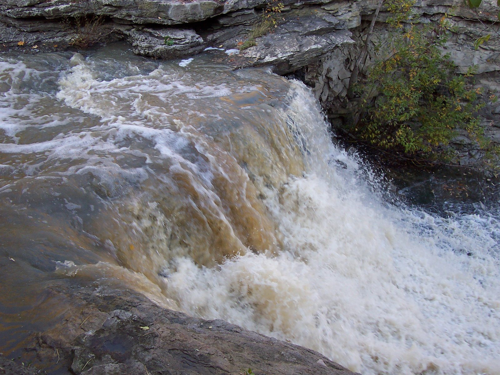
Thirty Road Falls
Ontario • 8 m
By Armen Suny · Last verified Jun 2026
Photo Credits (3)
Difficulty
Moderate
Trail Length
0.6 km
Trail Type
Out And Back
About Thirty Road Falls
Thirty Road Falls is a small stream waterfall located in the Niagara region of Ontario (coordinates 43.1677, -79.5138). The feature sits near rural roads and appears in a wooded/field edge setting rather than inside a developed provincial park. Flow and appearance are highly seasonal, highest in spring and after heavy rain, and reduced in dry periods. Precise height and official measurements are not readily available from public trail databases.
The Setting
Thirty Road Falls sits at 177 metres within Featherstone, in the foothills of Ontario. The falls drop 8 metres.
Height: 26 feet
Nearby Falls Worth Visiting
Beamer's Falls (14 m) lies 5.1 kilometres to the west. Also nearby: East of Fifty Falls (10 m, 10.8 km) and Puddicombe Falls (6 m, 10.5 km).
Trail & Hike Details
Trail Description
There is no well-documented maintained trail to Thirty Road Falls in common guide sources. Expect a short, unmarked approach from a nearby road or pullout through a roadside woodlot or field edge. Terrain is likely uneven with roots, loose rocks, and possibly a short steep bank down to the stream. Trail conditions and access may change seasonally and with landowner permissions.
What to Expect
The falls drop 8 metres.
Accessibility
The trail is not wheelchair accessible. Uneven terrain and elevation changes require steady footing.
Frequently Asked Questions
🐶 Are Dogs Allowed at Thirty Road Falls?
❌ Dogs are not allowed
Are There Any Fees or Permits Required?
🆖 No fees required
🏊 Is There Swimming at Thirty Road Falls?
❌ Swimming is not allowed
When to Visit
Spring (late March–May) for highest water flow and late fall for color. Summer visits are possible but flow may be reduced. Winter can offer ice formations but surfaces will be icy and hazardous.
Seasonal Access
The best time to visit is Spring, Summer, Fall, and Winter. Check with the managing park or local authority for current conditions.
Safety Information
Hazards may include slippery rocks and banks, unstable edges, swift water after heavy rain, poison ivy, ticks, and seasonal ice. The site may be adjacent to private property, trespassing risks and encounters with agriculture/working lands are possible. Do not attempt to climb the falls or enter fast-moving water. Use caution in winter due to black ice and unstable frozen waterfalls.
Current Water Conditions
0.1 m³/s
Current discharge — how much water is flowing
About average for this time of year
Based on 34 years of record
2.96 m
Water depth at gauge
7-Day Discharge Trend
What does this mean for your visit?
Flow is about average for this time of year.
About This Gauge
7-Day Flow Outlook
Based on the WSC gauge TWENTY MILE CREEK ABOVE SMITHVILLE (7 km away).
Today
Moderate
0.1 m³/s
8/10Tomorrow
Moderate
0.1 m³/s
8/10Tue
Moderate
0.1 m³/s
6/10Wed
Moderate
0.3 m³/s
6/10Thu
Moderate
0.2 m³/s
8/10Fri
Moderate
0.2 m³/s
6/10Sat
Moderate
0.1 m³/s
6/10Best window: Today — moderate flow, cloudy (trip score 8/10).
Best time of year: this gauge typically runs highest from mid February to mid April, peaking in April.
How we calculate this
This is a transparent outlook, not a precise forecast. We take the waterfall's current flow strength (how it ranks against its historical normal for today, from the nearest WSC stream gauge), carry that ranking forward along the gauge's seasonal curve, and nudge it for forecast rain. Confidence is highest for the next day or two and falls further out. Always check official conditions and your own judgment before visiting — high flows can be dangerous.
Know when to go.
Get a free email alert when waterfalls near Hamilton hit peak flow. We only send when conditions are worth the trip — no weekly newsletters, no spam.
Weather Forecast
Location & Access
Getting There
The falls are at approximately 43.1677, -79.5138 in the Niagara/Hamilton region. Nearest cities mentioned are Hamilton (~19 miles), Niagara University (~22 miles) and Youngstown (~24 miles). Access is most likely from local roads (including a road named Thirty Road or a numbered county road). Visitors should use a mapped route to the coordinates and expect a short roadside approach. The site may be on or adjacent to private land, verify land access before crossing fences or entering fields.
Get Directions on Google MapsParking
There is likely no formal parking lot. Parking may be roadside on a shoulder or in an informal pullout. Park legally and safely off the roadway and avoid blocking gates or driveways. If no safe roadside parking exists, consider parking in a nearby town and walking in.
Elevation
177 metres above sea level
Coordinates
43.167666° N, -79.513755° W
Land Management
Managed by Bruce Trail Conservancy
Visitor Tips & Gear
• Confirm land access before visiting; the waterfall may be adjacent to private property. • Wear sturdy shoes or boots; banks and rocks will be slippery when wet. • Bring insect repellent (ticks and mosquitoes can be common). • Park safely and legally; avoid blocking roads or farm gates. • Do not climb unstable banks or attempt to climb the falls. • Pack out all trash and respect local vegetation and wildlife. • Check recent local trip reports or mapping apps for updated access information.
Where to Stay
Browse vacation cabins and private rentals nearby
Unique outdoor stays — tents, yurts, and treehouses
Rent a campervan or RV for your waterfall road trip
Some links are affiliate links. We may earn a commission at no extra cost to you.
Nearby Campground
Cave Springs Camp
6.1 km away
Additional Information
Nearby Attractions
The falls are within driving distance of attractions in the Niagara region and the Hamilton area. Major draws in the broader region include Niagara Falls and the Niagara wine route; check local maps for parks, conservation areas, and trails in the immediate vicinity.
Wildlife
Typical regional wildlife may include white-tailed deer, small mammals (raccoons, squirrels), songbirds, and water-associated species. Be aware of ticks and typical mosquito activity in warmer months.
Cities near Thirty Road Falls
Nearby Waterfalls

Writing about Thirty Road Falls? Embed this waterfall on your site for free.