
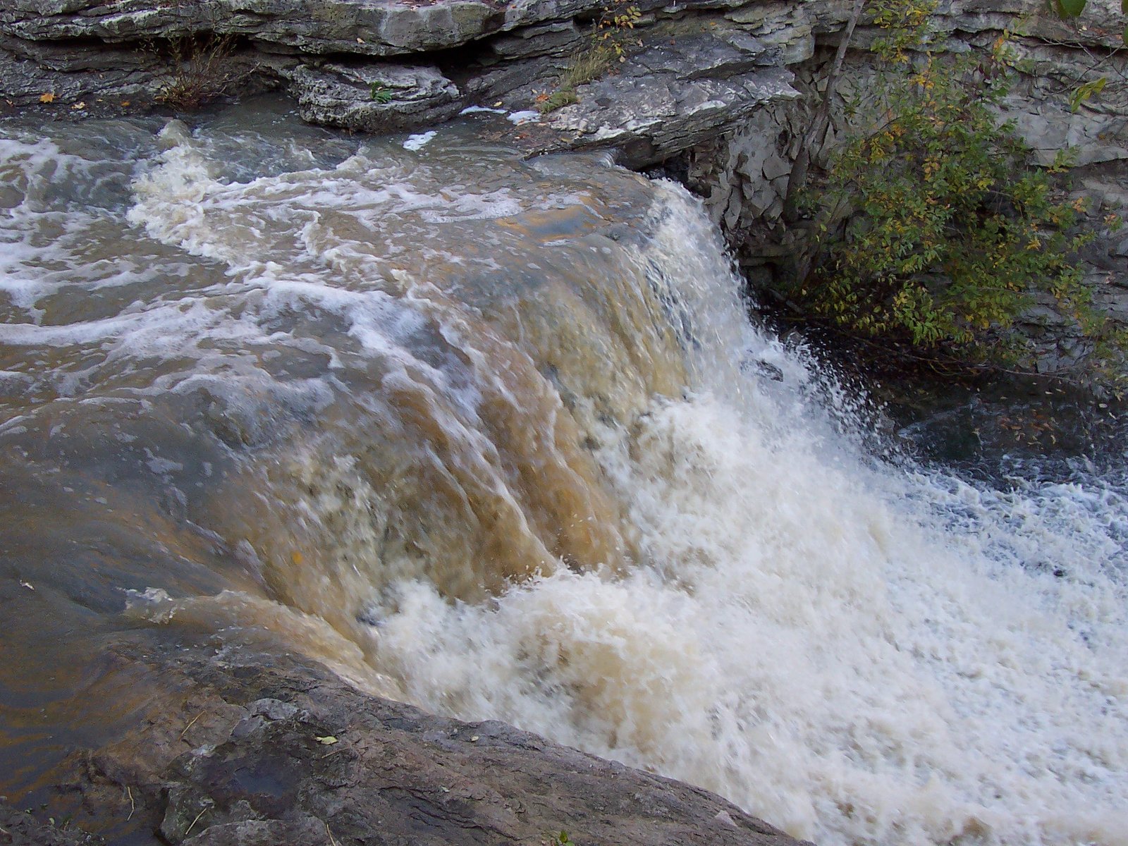
Lower Beamer Falls
Ontario • 6 m
By Armen Suny · Last verified Jun 2026
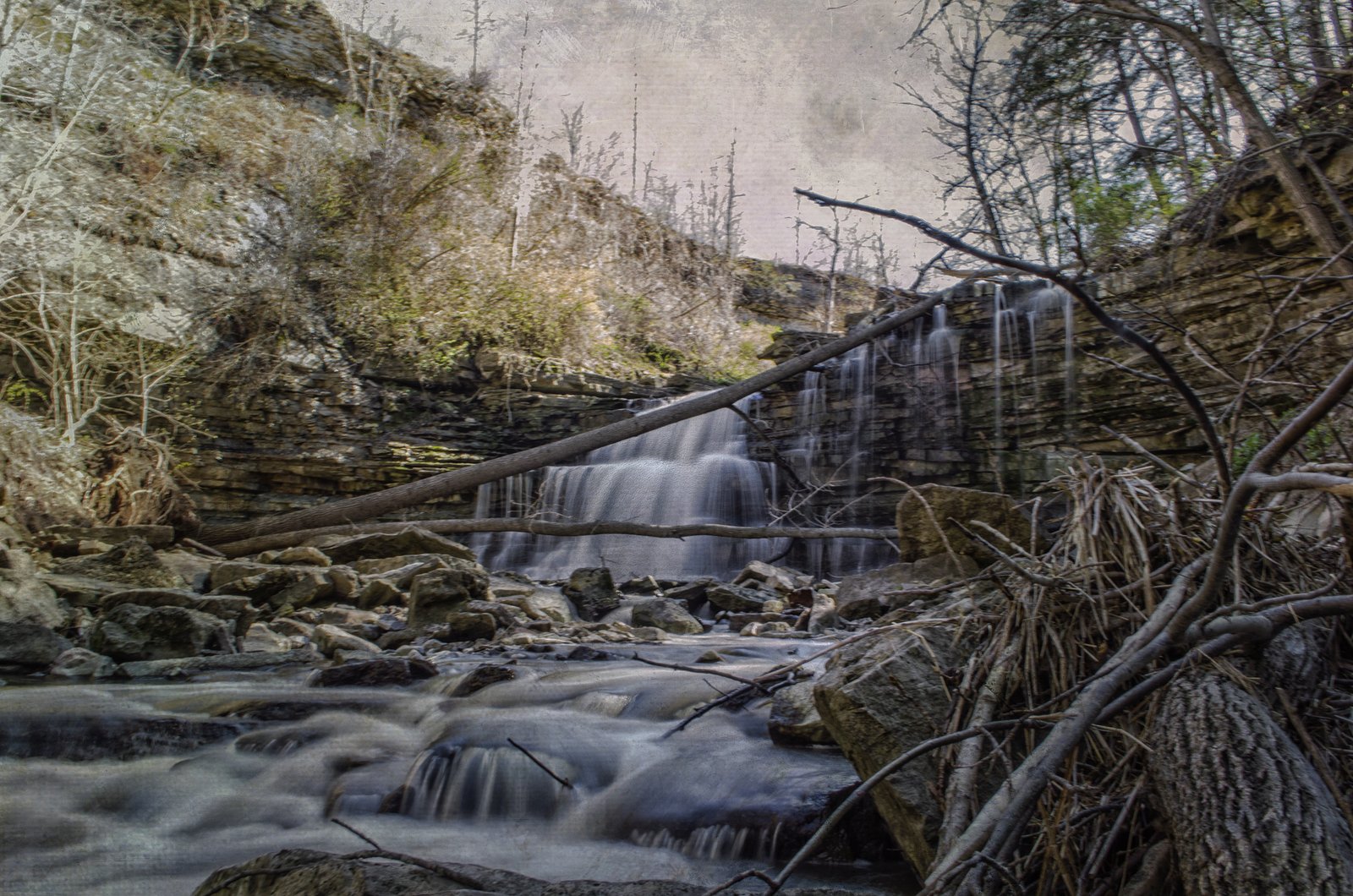
Photo Credits (5)
Difficulty
Moderate
Trail Length
4.2 km
Trail Type
Loop
Elevation Gain
115 m
About Lower Beamer Falls
Lower Beamer Falls is a small cascade on the Niagara Escarpment in the Grimsby/Jordan area of southern Ontario (coordinates: 43.1836, -79.5728). The falls are set in a wooded escarpment gorge and are most often visited from a short trail or viewpoint above the stream. Flow and appearance vary seasonally (typically highest in spring and after heavy rain). Specific published details (exact vertical drop and formalized trail metrics) are limited or vary by source, so some details below are presented cautiously.
The Setting
Lower Beamer Falls sits at 198 metres within Beamer Memorial, in the foothills of Ontario. The falls drop 6 metres.
Height: 19 feet
Nearby Falls Worth Visiting
Beamer's Falls (14 m) lies 0.2 kilometres to the west. Also nearby: East of Fifty Falls (10 m, 5.6 km) and Fifty Road Cascade (10 m, 6.0 km).
Trail & Hike Details
The Approach
The moderate 4.2-km loop trail gains 115 metres of elevation on the way to the falls.
Trail Description
A generally short, wooded trail leads from the parking or roadside access down to viewpoints along the escarpment and the stream that feeds Lower Beamer Falls. Expect uneven surfaces, roots, rock steps or short stair sections in places. Trails are typically well-defined but may be narrow in the gorge. There may be fenced viewing areas in higher-use sections; off-trail travel into the gorge is discouraged due to cliff edges and unstable rock.
What to Expect
The falls drop a gentle 6 metres.
Accessibility
The trail is not wheelchair accessible. Uneven terrain and elevation changes require steady footing.
Frequently Asked Questions
🐶 Are Dogs Allowed at Lower Beamer Falls?
❌ Dogs are not allowed
Are There Any Fees or Permits Required?
🆖 No fees required
🏊 Is There Swimming at Lower Beamer Falls?
❌ Swimming is not allowed
When to Visit
Spring (high runoff) for strongest flows and fall for foliage color. Early mornings or weekdays reduce crowds. Avoid visiting immediately after heavy rains if you plan to approach stream edges, flows can be stronger and banks unstable.
Seasonal Access
The best time to visit is Spring, Summer, Fall, and Winter. Check with the managing park or local authority for current conditions.
Safety Information
Hazards include slippery rock, steep drop-offs, unstable cliff edges, fast-flowing water after rain, and seasonal ice. Stay on marked trails, keep a safe distance from cliff edges, supervise children closely, and avoid approaching the water during high flow. Carry a basic first-aid kit and let someone know your plans. Check for posted warnings or closures from local authorities before visiting.
Current Water Conditions
0.1 m³/s
Current discharge — how much water is flowing
About average for this time of year
Based on 34 years of record
2.96 m
Water depth at gauge
7-Day Discharge Trend
What does this mean for your visit?
Flow is about average for this time of year.
About This Gauge
7-Day Flow Outlook
Based on the WSC gauge TWENTY MILE CREEK ABOVE SMITHVILLE (8 km away).
Today
Moderate
0.1 m³/s
8/10Tomorrow
Moderate
0.1 m³/s
8/10Tue
Moderate
0.1 m³/s
6/10Wed
Moderate
0.3 m³/s
6/10Thu
Moderate
0.2 m³/s
8/10Fri
Moderate
0.2 m³/s
6/10Sat
Moderate
0.1 m³/s
6/10Best window: Today — moderate flow, cloudy (trip score 8/10).
Best time of year: this gauge typically runs highest from mid February to mid April, peaking in April.
How we calculate this
This is a transparent outlook, not a precise forecast. We take the waterfall's current flow strength (how it ranks against its historical normal for today, from the nearest WSC stream gauge), carry that ranking forward along the gauge's seasonal curve, and nudge it for forecast rain. Confidence is highest for the next day or two and falls further out. Always check official conditions and your own judgment before visiting — high flows can be dangerous.
Know when to go.
Get a free email alert when waterfalls near Hamilton hit peak flow. We only send when conditions are worth the trip — no weekly newsletters, no spam.
Weather Forecast
Location & Access
Getting There
The falls are located on the Niagara Escarpment near Grimsby/Jordan in southern Ontario (use the provided coordinates 43.1836, -79.5728). Access is generally from local conservation area access points or small roadside/parking areas on local municipal roads; exact approach routes vary depending on which parking area you use. Expect a short walk from parking to the gorge/viewpoint. Confirm access and parking with the managing conservation authority or local municipality before you go.
Get Directions on Google MapsParking
Limited parking is typical: small conservation-area lots or roadside parking. Parking may be tight on busy days; use designated lots if available and obey local signs. Check for signage or parking maps from the local conservation authority.
Elevation
198 metres above sea level
Coordinates
43.183550° N, -79.572825° W
Land Management
Managed by Niagara Peninsula Conservation Authority
Visitor Tips & Gear
• Wear sturdy footwear with good traction, rocks and boardwalks can be slippery. • Stay on marked trails and behind any railings; cliff edges and loose rock are hazards. • Park only in designated areas and avoid blocking driveways or gates. • Check recent trail and access reports (local conservation authority or trail sites) for closures or conditions before visiting. • Be prepared for limited facilities (no guaranteed restrooms or water).
As an Amazon Associate, we earn from qualifying purchases.
With 4.2 km and 115 m of elevation gain, sturdy boots and trekking poles will help on this moderate trail. Icy conditions are common in winter — traction cleats are a smart addition.

Columbia Watertight II Rain Jacket
Packs into its own pocket, seam-sealed, and keeps you dry from spray and surprise rain.

Polarized Sunglasses (Knockaround)
Cuts glare off the water so you actually see the falls — and your photos turn out better too.

Earth Pak Waterproof Dry Bag
Keeps your phone and gear dry when waterfall mist soaks everything else.

Waterproof Phone Pouch (AiRunTech)
Cheap insurance — take photos right next to the falls without killing your phone.

Timberland Euro Sprint Mid Waterproof
Trusted waterproof boot with premium leather and grippy rubber sole — reliable on rocky, wet trails.

TrailBuddy Trekking Poles
Lightweight aluminum, cork grips, and flip-locks that actually hold — a best-seller for good reason.
Where to Stay
Browse vacation cabins and private rentals nearby
Unique outdoor stays — tents, yurts, and treehouses
Rent a campervan or RV for your waterfall road trip
Some links are affiliate links. We may earn a commission at no extra cost to you.
Nearby Campground
Cave Springs Camp
11.2 km away
Additional Information
Nearby Attractions
Bruce Trail sections and other Niagara Escarpment viewpoints, local wine country (Jordan/Grimsby/Jordan Village), nearby Hamilton waterfalls and conservation areas. Niagara Falls and Niagara-on-the-Lake are regionally accessible but are larger, separate attractions.
Wildlife
Common species include songbirds, raptors (seasonal), small mammals, amphibians and white-tailed deer. Take standard precautions for ticks and be aware of local seasonal wildlife activity.
Cities near Lower Beamer Falls
Nearby Waterfalls
Writing about Lower Beamer Falls? Embed this waterfall on your site for free.