Stotan Falls
By Armen Suny · Last verified Jun 2026
Photo Credits (4)
Difficulty
Drive Up
Trail Length
0.2 km
Trail Type
Out And Back
About Stotan Falls
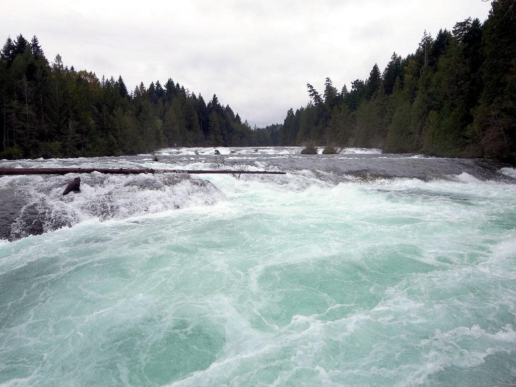
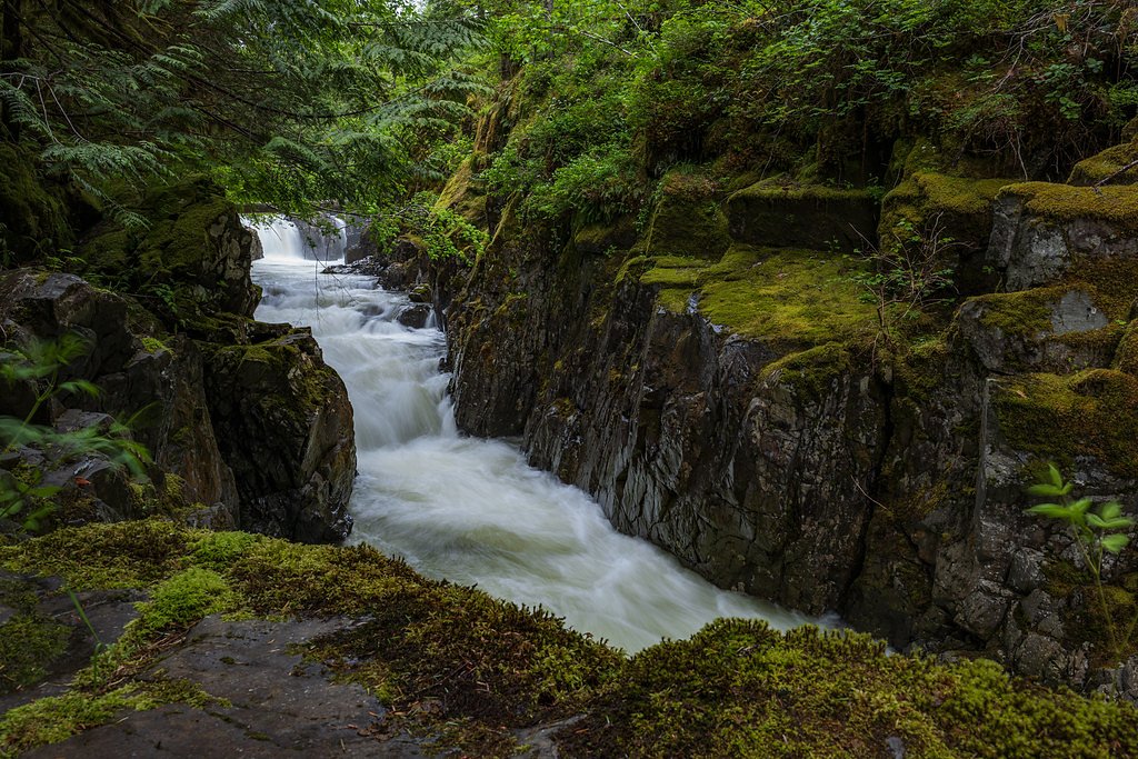
Stotan Falls is a forested, likely multi-tiered creek waterfall on Vancouver Island near Courtenay, British Columbia (coordinates 49.6818, -125.0543). Visitor reports suggest it is a relatively small, scenic cascade set in a coastal temperate rainforest. Seasonal flow may vary considerably, highest in spring snowmelt and after heavy rains, lower in late summer.
Why This Waterfall Exists
Stotan Falls flows over layered sedimentary rock laid down about 66-101 million years ago. Over time, the stream has worn through these layers at different rates, creating the step that forms the waterfall.
Trail & Hike Details
The Approach
No hiking required. Stotan Falls is accessible by vehicle with a roadside viewing area.
Trail Description
Trail to the falls (where present) is likely a short forested walk that may include roots, mud and uneven footing. Viewpoints may be informal and there may be limited or no constructed viewing platforms or railings. Exact route details and turn-by-turn directions are not confirmed here; carry a map or GPS track if available.
What to Expect
Expect a small to moderate cascade in a coastal rainforest setting. Surrounding terrain may include dense vegetation, wet rocks, and steep banks near the stream. Flow is seasonal and can be much stronger in spring or after heavy rain. Facilities (toilets, signage, maintained trails) are likely minimal or absent. Cell service may be intermittent.
Accessibility
This waterfall is viewable from a vehicle-accessible area. No hiking is required.
Frequently Asked Questions
🐶 Are Dogs Allowed at Stotan Falls?
❌ Dogs are not allowed
Are There Any Fees or Permits Required?
🆖 No fees required
🏊 Is There Swimming at Stotan Falls?
❌ Swimming is not allowed
When to Visit
Spring (late March–May) for highest flows and lush vegetation; early summer for generally reliable conditions and fewer muddy sections; fall after rainstorms for good water flow. Late summer can be lower-flow and less impressive. Avoid visiting during heavy storms or when roads are flooded/washed out.
Seasonal Access
The best time to visit is Spring, Summer, and Fall. Winter access may be limited. Check with the managing park or local authority for current conditions.
Safety Information
Hazards may include slippery rocks, steep or unstable banks, sudden increases in water flow after rain, limited cell coverage, and rough or unmaintained access roads. There may be no formal railings or viewing platforms. Use caution near the water, stay on durable surfaces, and avoid getting too close to edges. If you encounter wildlife, give animals space and follow local safety guidance. If uncertain about road conditions, check with local authorities or visitor centers before driving remote spurs.
Current Water Conditions
10.9 m³/s
Current discharge — how much water is flowing
Much lower than usual for this time of year
Based on 70 years of record
19.90 m
Water depth at gauge
7-Day Discharge Trend
What does this mean for your visit?
Flow is well below normal for this time of year, so the waterfall may be a trickle.
About This Gauge
7-Day Flow Outlook
Based on the WSC gauge PUNTLEDGE RIVER AT COURTENAY (2 km away).
Today
Barely Flowing
11 m³/s
4/10Tomorrow
Barely Flowing
12 m³/s
5/10Tue
Barely Flowing
11 m³/s
4/10Wed
Barely Flowing
10 m³/s
4/10Thu
Barely Flowing
11 m³/s
3/10Fri
Barely Flowing
11 m³/s
4/10Sat
Barely Flowing
10 m³/s
4/10Best window: Tomorrow — barely flowing flow, sunny (trip score 5/10).
Best time of year: this gauge typically runs highest from late April to late June, peaking in May.
How we calculate this
This is a transparent outlook, not a precise forecast. We take the waterfall's current flow strength (how it ranks against its historical normal for today, from the nearest WSC stream gauge), carry that ranking forward along the gauge's seasonal curve, and nudge it for forecast rain. Confidence is highest for the next day or two and falls further out. Always check official conditions and your own judgment before visiting — high flows can be dangerous.
Know when to go.
Get a free email alert when waterfalls near Courtenay hit peak flow. We only send when conditions are worth the trip — no weekly newsletters, no spam.
Weather Forecast
Location & Access
Getting There
The falls are located on northeastern Vancouver Island near Courtenay (≈2.4 miles), Campbell River (≈24.6 miles) and Powell River (≈31.2 miles). Use coordinates 49.6818, -125.0543 to locate the site. Access is typically via local roads and an unpaved spur or small trail; some approaches may use forest service or private roads. Expect limited signage; a GPS or map is recommended.
Get Directions on Google MapsParking
Parking is likely limited to a small pullout or roadside parking near the trailhead. Vehicles with low clearance may be fine for paved roads but forest service spurs can be rough. Park legally and avoid blocking gates or driveways.
Elevation
85 metres above sea level
Coordinates
49.681782° N, -125.054262° W
Visitor Tips & Gear
• Use the provided coordinates and a reliable map/GPS to find the trailhead. • Wear sturdy, waterproof footwear, wet and slippery rock is common. • Be cautious near edges; banks and ledges can be unstable. • Bring insect repellent in spring/summer. • Leave no trace: pack out garbage and avoid disturbing vegetation. • If driving on forest service roads, check conditions and travel carefully; a vehicle with moderate clearance may be helpful.
Where to Stay
Browse vacation cabins and private rentals nearby
Unique outdoor stays — tents, yurts, and treehouses
Rent a campervan or RV for your waterfall road trip
Some links are affiliate links. We may earn a commission at no extra cost to you.
Nearby Campground
Camp Gilwell
1.9 km away
Additional Information
Nearby Attractions
Courtenay and Comox area amenities and parks (shops, services). Nearby natural attractions on northeastern Vancouver Island include regional trails, lakes, and provincial parks, confirm distances and access before visiting. Strathcona Provincial Park and Elk Falls Provincial Park are within a broader day-trip distance but not immediate neighbors.
Wildlife
Typical Vancouver Island wildlife may be present: black bears, cougars, deer, small mammals, and a variety of birds. Expect insects (including mosquitoes and ticks) in warmer months. Keep food secured and be bear-aware.
Cities near Stotan Falls
Nearby Waterfalls

Writing about Stotan Falls? Embed this waterfall on your site for free.