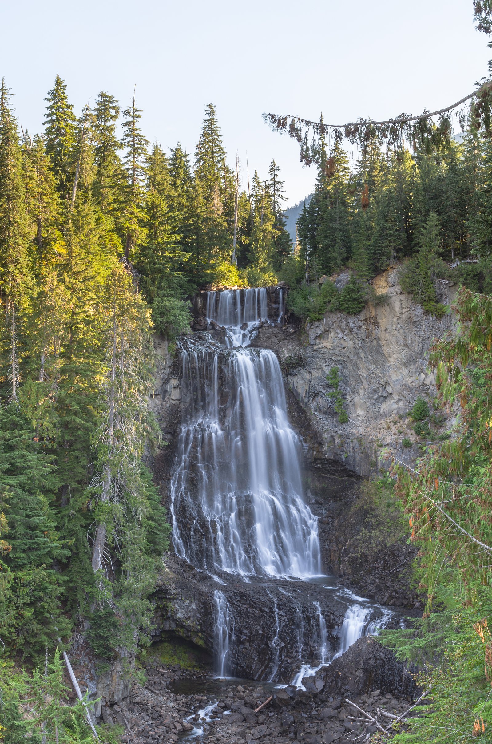
Soo Falls
British Columbia • 30 m
By Armen Suny · Last verified Jun 2026
Difficulty
Easy
Trail Length
0.6 km
Trail Type
Out And Back
About Soo Falls
Soo Falls is a modest, forested cascade in the coastal interior of British Columbia at approximate coordinates 50.2318, -123.0641. The falls sit in a steep, mountainous valley along secondary roads off Highway 99 (the Duffey Lake / Lillooet corridor). Water flow can vary widely by season, high in spring/early summer from snowmelt and lower in late summer and autumn. Exact published height and official name usage are inconsistent in online resources; local references and visitor reports describe it as a small multi-tiered drop that is best visited as a short roadside outing or brief hike from a nearby pullout.
The Setting
Soo Falls sits at 675 metres in the hills of British Columbia. The falls drop 30 metres.
Why This Waterfall Exists
Soo Falls flows over hard intrusive rock laid down about 145-162 million years ago. These resistant rocks form a durable ledge that water cannot easily wear away, creating a 98-foot drop where softer material downstream has already eroded.
Nearby Falls Worth Visiting
Alexander Falls (43 m) lies 11.7 kilometres to the southwest. Also nearby: Rainbow Falls (29 m, 12.4 km).
Trail & Hike Details
Trail Description
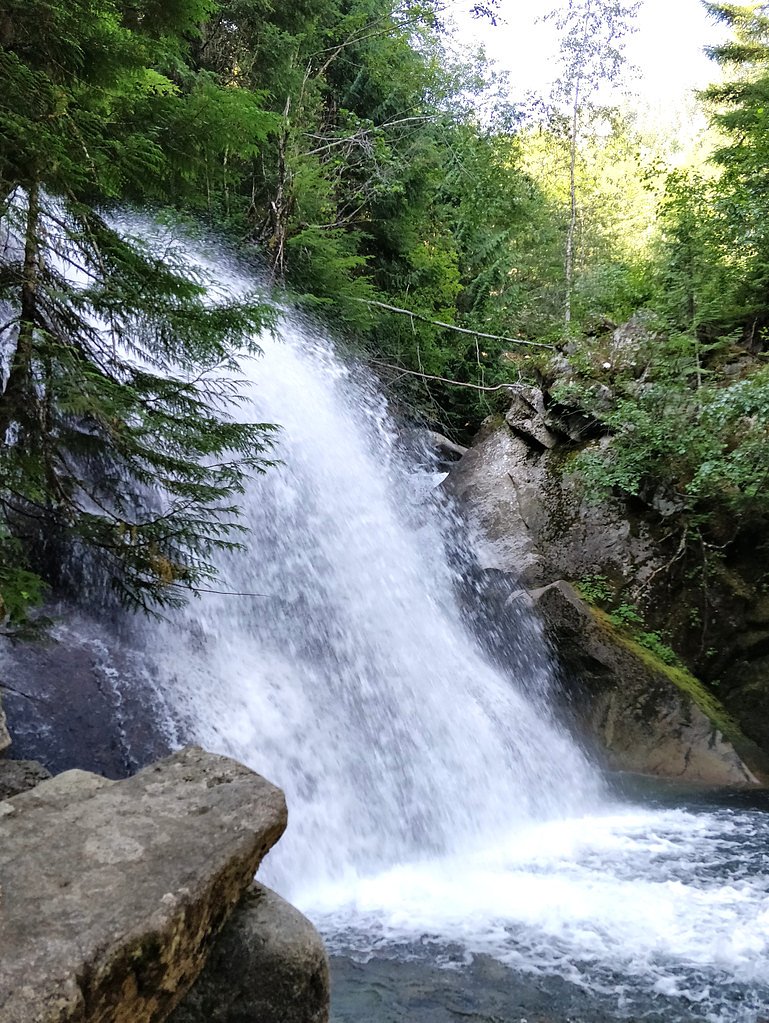
Published trail descriptions are limited. Visitor reports suggest a short, informal path or rough scramble from a roadside pullout to viewpoints above or beside the falls. Trails, if present, may be unmarked, narrow and involve uneven ground, roots and rocks. Expect limited infrastructure (no official viewpoints, handrails or maintained stairs).
What to Expect
The falls cascade 30 metres over hard intrusive rock.
Accessibility
The trail is short and relatively flat, but the surface may be uneven. Contact the managing agency for accessibility details.
Frequently Asked Questions
🐶 Are Dogs Allowed at Soo Falls?
❌ Dogs are not allowed
Are There Any Fees or Permits Required?
🆖 No fees required
🏊 Is There Swimming at Soo Falls?
❌ Swimming is not allowed
When to Visit
Late spring to early summer for strongest flows and lush surroundings. Summer offers easier road access and more predictable weather. Avoid heavy rain events and freshets that can make approaches dangerous; winter visits may be hazardous because of ice, snow and avalanche risk.
Seasonal Access
The best time to visit is Spring, Summer, and Fall. Winter access may be limited. Check with the managing park or local authority for current conditions.
Safety Information
Hazards can include slippery wet rock, steep drop-offs, fast-moving water, loose footing on trails, and variable road conditions. River and waterfall flows can rise rapidly during spring freshet or heavy rain, stay well back from the edge. Winter and shoulder seasons may bring ice, snow and avalanche risk on nearby slopes. Emergency services may be far away and cell coverage unreliable; travel prepared and inform someone of your plans.
Current Water Conditions
5.6 m³/s
Current discharge — how much water is flowing
Much lower than usual for this time of year
Based on 29 years of record
6.01 m
Water depth at gauge
7-Day Discharge Trend
What does this mean for your visit?
Flow is well below normal for this time of year, so the waterfall may be a trickle.
About This Gauge
This gauge is on a nearby waterway and may not reflect exact conditions at the falls.
7-Day Flow Outlook
Based on the WSC gauge FITZSIMMONS CREEK BELOW BLACKCOMB CREEK (15 km away).
Today
Barely Flowing
5.6 m³/s
4/10Tomorrow
Barely Flowing
5.8 m³/s
4/10Wed
Barely Flowing
5.6 m³/s
4/10Thu
Barely Flowing
5.6 m³/s
4/10Fri
Barely Flowing
5.6 m³/s
3/10Sat
Low
6.1 m³/s
4/10Sun
Low
5.8 m³/s
4/10Best window: Today — barely flowing flow, cloudy (trip score 4/10).
Best time of year: this gauge typically runs highest from late May to mid August, peaking in June.
How we calculate this
This is a transparent outlook, not a precise forecast. We take the waterfall's current flow strength (how it ranks against its historical normal for today, from the nearest WSC stream gauge), carry that ranking forward along the gauge's seasonal curve, and nudge it for forecast rain. Confidence is highest for the next day or two and falls further out. Always check official conditions and your own judgment before visiting — high flows can be dangerous.
Know when to go.
Get a free email alert when waterfalls near Lillooet hit peak flow. We only send when conditions are worth the trip — no weekly newsletters, no spam.
Weather Forecast
Location & Access
Getting There
Access is typically from secondary roads off Highway 99 (the Duffey Lake / Lillooet corridor). The falls are in a remote mountain area; expect long driving distances from larger towns. Use detailed maps or a reliable GPS with the coordinates 50.2318, -123.0641. Cell service may be intermittent; allow extra travel time on narrow or unpaved sections.
Get Directions on Google MapsParking
There may be a small roadside pullout or informal parking near the access point rather than a formal parking lot. Parking space can be limited and may be on gravel or shoulder; park well off the travel lane and avoid blocking logging or local traffic.
Elevation
675 metres above sea level
Coordinates
50.231792° N, -123.064103° W
Visitor Tips & Gear
• Confirm current road and weather conditions before traveling; some approach roads may be rough or seasonal. • Wear sturdy, grippy footwear, rocks and roots near the falls can be slippery. • Keep a safe distance from the edge and avoid climbing on wet rock ledges. • Carry water, snacks, and a basic first-aid kit; cell coverage may be unreliable. • Pack out all trash and follow Leave No Trace principles. • If traveling in bear country, carry bear spray and know how to use it.
Where to Stay
Browse vacation cabins and private rentals nearby
Unique outdoor stays — tents, yurts, and treehouses
Rent a campervan or RV for your waterfall road trip
Some links are affiliate links. We may earn a commission at no extra cost to you.
Nearby Campground
Madeley Lake Campsite
7.2 km away
Additional Information
Nearby Attractions
The falls are on the Duffey Lake / Highway 99 corridor between larger centres (Pemberton, Lillooet). The corridor includes many scenic stops, backcountry access points and provincial parks; research nearby parks and trailheads for additional things to see.
Wildlife
Typical interior/coastal mountain wildlife may be present: black bears, deer, small mammals, and a variety of birds. Salmon runs may occur in nearby larger river systems (seasonal and location-dependent). Always store food securely and be aware of wildlife safety practices.
Cities near Soo Falls
Nearby Waterfalls
Writing about Soo Falls? Embed this waterfall on your site for free.