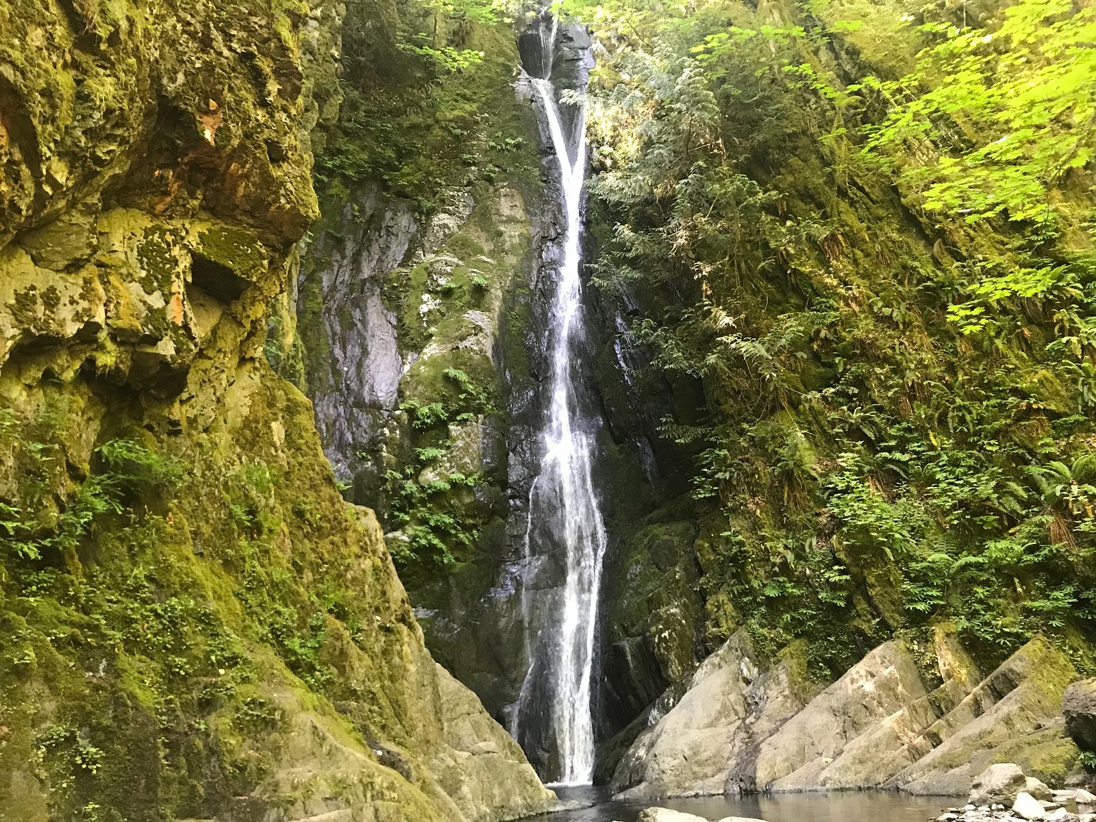
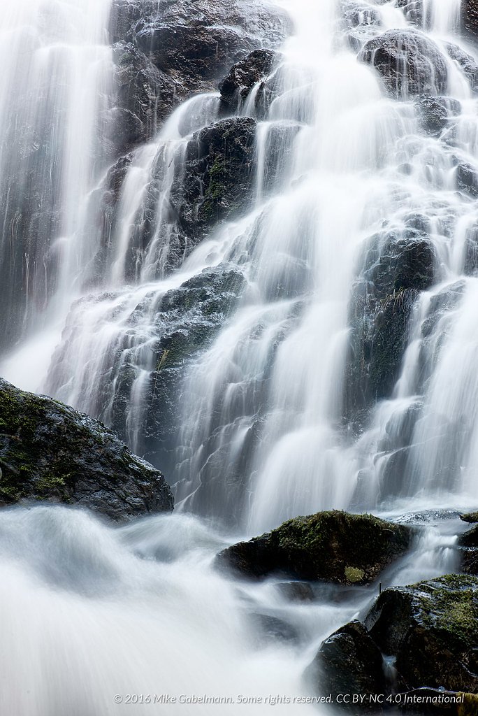
Sitting Lady Falls
British Columbia • 18 m
By Armen Suny · Last verified Jun 2026
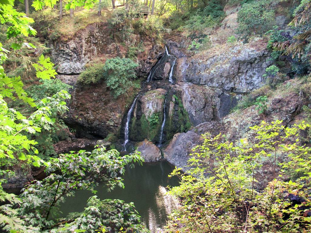
Photo Credits (5)
Difficulty
Easy
Trail Length
2.7 km
Trail Type
Loop
Elevation Gain
74 m
About Sitting Lady Falls
Sitting Lady Falls is a forested waterfall on southern Vancouver Island near the Victoria region (coordinates ~48.3884, -123.5224). The site appears to be a smaller, wooded cascade set inside a coastal temperate rainforest environment. Exact details about the fall's official name, measured height, and formal trailhead are not well-documented in major park databases; the description below uses conservative, visitor-focused language and advises confirming route details with local resources (park offices, AllTrails, or recent trip reports) before traveling.
The Setting
Sitting Lady Falls sits at 52 metres within Witty's Lagoon Regional Park, in the coastal lowlands of British Columbia. The falls drop 18 metres.
Why This Waterfall Exists
Sitting Lady Falls flows over Metchosin Formation, a hard volcanic rock layer deposited about 34-66 million years ago. These resistant rocks form a durable ledge that water cannot easily wear away, creating a 58-foot drop where softer material downstream has already eroded.
Nearby Falls Worth Visiting
Niagara Falls (48 m) lies 10.8 kilometres to the north. Also nearby: Mary Vine Falls (21 m, 15.8 km) and Goldstream Falls (7 m, 9.0 km).
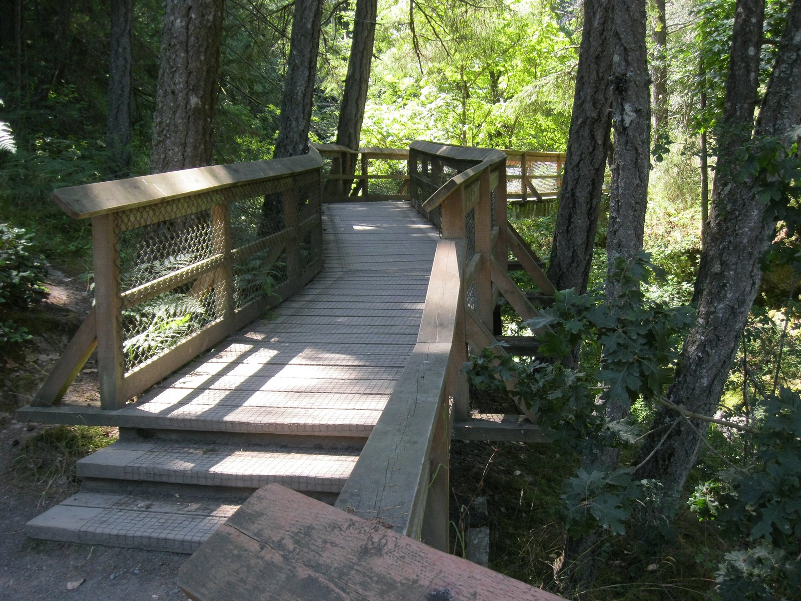
Trail & Hike Details
The Approach
The easy 2.7-km loop trail gains 74 metres of elevation on the way to the falls.
Trail Description
Detailed, confirmed trail directions are not available here. Reports for similar small coastal-island waterfalls describe a forested trail with roots and rocks, possibly steep or slippery near the creek and falls. Expect single-track hiking through second-growth or mixed forest, with short steep sections and uneven footing closer to the cascade. There may be informal social trails or scrambling required to reach a base viewpoint.
What to Expect
The falls drop 18 metres over hard volcanic rock.
Accessibility
The trail is not wheelchair accessible. Uneven terrain and elevation changes require steady footing.
Frequently Asked Questions
🐶 Are Dogs Allowed at Sitting Lady Falls?
❌ Dogs are not allowed
Are There Any Fees or Permits Required?
🆖 No fees required
🏊 Is There Swimming at Sitting Lady Falls?
❌ Swimming is not allowed
When to Visit
Late winter to spring for highest flows; late spring through early fall for easier hiking conditions and better weather. Summer can have lower water flow but drier trails.
Seasonal Access
The best time to visit is Spring, Summer, Fall, and Winter. Check with the managing park or local authority for current conditions.
Safety Information
Potential hazards include slippery rock and wet moss near the falls, steep drop-offs, unstable banks, cold water, variable flow depending on season, ticks/insects, and limited cellphone reception. Wear appropriate footwear, stay on established trails where present, do not attempt technical scrambles without experience, and avoid standing under overhangs or loose rock. If conditions are icy or flooded, do not attempt the approach. Always tell someone your plans and expected return time.
Current Water Conditions
Based on a Water Survey of Canada gauge 39.5 km away
0.3 m³/s
Current discharge — how much water is flowing
Much lower than usual for this time of year
Based on 73 years of record
0.41 m
Water depth at gauge
7-Day Discharge Trend
What does this mean for your visit?
Flow is well below normal for this time of year, so the waterfall may be a trickle.
About This Gauge
This gauge is on a regional waterway. Conditions at the falls may differ, especially after local rain.
7-Day Flow Outlook
Based on the WSC gauge KOKSILAH RIVER AT COWICHAN STATION (39 km away).
Today
Barely Flowing
0.3 m³/s
5/10Tomorrow
Barely Flowing
0.2 m³/s
4/10Tue
Barely Flowing
0.2 m³/s
4/10Wed
Barely Flowing
0.3 m³/s
3/10Thu
Low
0.3 m³/s
4/10Fri
Barely Flowing
0.2 m³/s
5/10Sat
Barely Flowing
0.2 m³/s
4/10Best window: Today — barely flowing flow, sunny (trip score 5/10).
Best time of year: this gauge typically runs highest from late November to late December, peaking in December.
How we calculate this
This is a transparent outlook, not a precise forecast. We take the waterfall's current flow strength (how it ranks against its historical normal for today, from the nearest WSC stream gauge), carry that ranking forward along the gauge's seasonal curve, and nudge it for forecast rain. Confidence is highest for the next day or two and falls further out. Always check official conditions and your own judgment before visiting — high flows can be dangerous.
Know when to go.
Get a free email alert when waterfalls near Victoria hit peak flow. We only send when conditions are worth the trip — no weekly newsletters, no spam.
Weather Forecast
Location & Access
Getting There
The falls are located on southern Vancouver Island, roughly southwest/west of central Victoria by the distances you provided. Access typically requires driving on local secondary roads; the precise trailhead and access road are not confirmed here. Visitors should consult a current map or a trail resource (AllTrails, provincial park pages, or local guidebooks) for the exact approach and driving directions before going.
Get Directions on Google MapsParking
Parking information is not confirmed. Expect either a small roadside parking area or informal/limited parking near the trailhead. If visiting a nearby park or trail network, follow posted signage and park only in designated spots.
Elevation
52 metres above sea level
Coordinates
48.388397° N, -123.522411° W
Land Management
Managed by Capital Region District
Visitor Tips & Gear
• Confirm exact trailhead location and current conditions via AllTrails, local parks pages, or recent trip reports before you go. • Wear sturdy, grippy footwear, rocks and roots can be slippery, especially when wet. • Use caution near edges and when scrambling to the base; wet rock and moss increase slip risk. • Bring insect repellent in warmer months and be prepared for muddy trail sections after rain. • Park only in designated areas and respect private property; many small waterfalls are on or adjacent to private land or unmaintained roads.
As an Amazon Associate, we earn from qualifying purchases.
This easy 2.7 km hike is straightforward — comfortable trail shoes and plenty of water should do. Icy conditions are common in winter — traction cleats are a smart addition.

Columbia Watertight II Rain Jacket
Packs into its own pocket, seam-sealed, and keeps you dry from spray and surprise rain.

Polarized Sunglasses (Knockaround)
Cuts glare off the water so you actually see the falls — and your photos turn out better too.

Earth Pak Waterproof Dry Bag
Keeps your phone and gear dry when waterfall mist soaks everything else.

Waterproof Phone Pouch (AiRunTech)
Cheap insurance — take photos right next to the falls without killing your phone.

Kahtoola MICROspikes
Cult-favorite traction cleats that grip ice and wet rock — essential for winter waterfall hikes.

JOBY GorillaPod Starter Kit
Wraps around railings and rocks for long-exposure waterfall shots — no flat surface needed.
Where to Stay
Browse vacation cabins and private rentals nearby
Unique outdoor stays — tents, yurts, and treehouses
Rent a campervan or RV for your waterfall road trip
Some links are affiliate links. We may earn a commission at no extra cost to you.
Nearby Campground
Goldstream Group Campsite - Goldminer (Lower) Site
8.6 km away
Nearby Hot Springs
Hot springs near Victoria, British Columbia

Olympic Hot Springs
Olympic Hot Springs flows at 118 degrees within Olympic National Park at 2,000 feet elevation, emerging 72 degrees above ambien...

Sol Duc Hot Springs
Sol Duc Hot Springs flows at 122 degrees Fahrenheit in Olympic National Park with permanently protected Class 1 status under Na...
Looking for a soak after your hike? Explore more hot springs near Victoria, British Columbia on SoakingSprings.
Explore British Columbia springsAdditional Information
Nearby Attractions
The general area around southern Vancouver Island includes attractions such as the city of Victoria, coastal parks and beaches, and regional trails. For precise nearby attractions, confirm the falls' official trailhead on a map or guide and explore nearby provincial or municipal park listings.
Wildlife
Typical Vancouver Island wildlife may include black-tailed deer, black bears, cougars (rare), raccoons, birds (including seabirds and forest species), and various small mammals. Use standard wildlife precautions: store food securely, keep distance, and be alert.
Cities near Sitting Lady Falls
Nearby Waterfalls
Other waterfalls named Sitting Lady Falls
1 other waterfall shares this name across Canada.
Writing about Sitting Lady Falls? Embed this waterfall on your site for free.